Saudi Arabia’s
heritage treasures
The eight historic sites inscribed on UNESCO’s World Heritage List tell a story of universal importance


One of the objectives of the increasingly outward-looking nation of Saudi Arabia, set out in the ambitious Vision 2030 document and its plan to create a more diverse and sustainable economy, is to open up the Kingdom to visitors as a destination for heritage tourism.
Among the attractions are many hundreds of historic sites. Some date back to prehistory and comprise key chapters in the story of humankind’s evolution and migration out of Africa. The twin rock art complexes of the Hail region, parts of which are 10,000 years old, are “among the most fascinating and largest rock art sites of the world.”
Others provide mute evidence of the transformation of the Arabian Peninsula over millennia from a lush haven of greenery, lakes and rivers to a largely arid landscape.
Even as the world is facing accelerating climate change, many of these sites tell the extraordinary and timely story of how human beings have adapted to changing environmental circumstances with determination and ingenuity.
Some of these sites were known to ancient Greek and Roman historians or to travelers in the 18th and 19th centuries. Others have been studied extensively by modern scholars and archaeologists from Saudi Arabia and around the world.
Very few, however, have been visited by tourists, and some are unknown even to Saudi citizens.
Now, all that is set to change, with a plan to make Saudi Arabia a major global destination, welcoming 100 million international and domestic visitors by 2030.
Part of that plan is to increase the number of visitable heritage destinations in the country from 241 to 447. Eight of those sites, which have been recognized by UNESCO as being of “outstanding universal value,” are the jewels in the crown of Saudi Arabia’s past.
Inspired by a successful international effort to save numerous sites and monuments in the Nile Valley, threatened by Egypt’s plans to build the Aswan High Dam, UNESCO adopted the Convention Concerning the Protection of the World’s Cultural and Natural Heritage at its 17th session in Paris in 1972.
Saudi Arabia was one of the first state parties to adopt the convention, which it did in August 1978. Over the next decades, many sites in the Kingdom were identified and protected, and in January 2007 Saudi Arabia nominated its first site for inscription on the World Heritage List — Hegra, the rock-carved city of the Nabataeans.
Saudi Arabia was one of the first state parties to adopt the convention, which it did in August 1978. Over the next decades, many sites in the Kingdom were identified and protected, and in January 2007 Saudi Arabia nominated its first site for inscription on the World Heritage List — Hegra, the rock-carved city of the Nabataeans.
Seven other sites have subsequently been adopted by UNESCO — the most recent was The Cultural Landscape of Al-Faw Archaelogical Area, listed in 2024 — and work is now under way on nominating more sites.
The accounts of how the Prophet Muhammad received and spread the word of God in the seventh century, and of how King Abdul Aziz Al-Saud, known as Ibn Saud, forged a nation from a multitude of disparate and warring tribes in the early 20th century, are as familiar as they are epic.
Less familiar, however, is the story of the deeper foundations of the region, upon which the modern state of Saudi Arabia was built and whose origins date back 10,000 years or more.
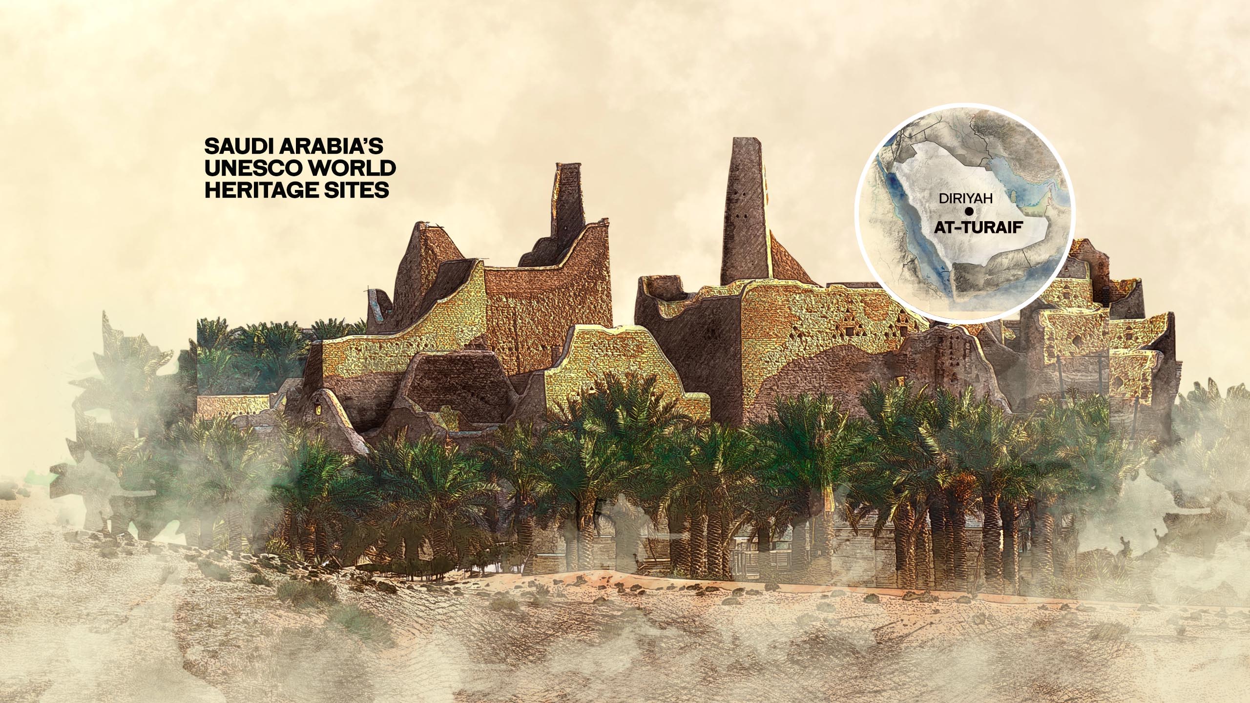
Together, Saudi Arabia’s eight UNESCO sites tell that story — from the wonders of the world’s largest collection of prehistoric petroglyphs, the mysterious rock-carved tombs of the ancient Nabataean city of Hegra and the world’s largest and oldest oasis, to the mud-brick settlement that is the birthplace of the modern Saudi state and the unique houses of old Jeddah, for centuries the gateway to the holy city of Makkah.


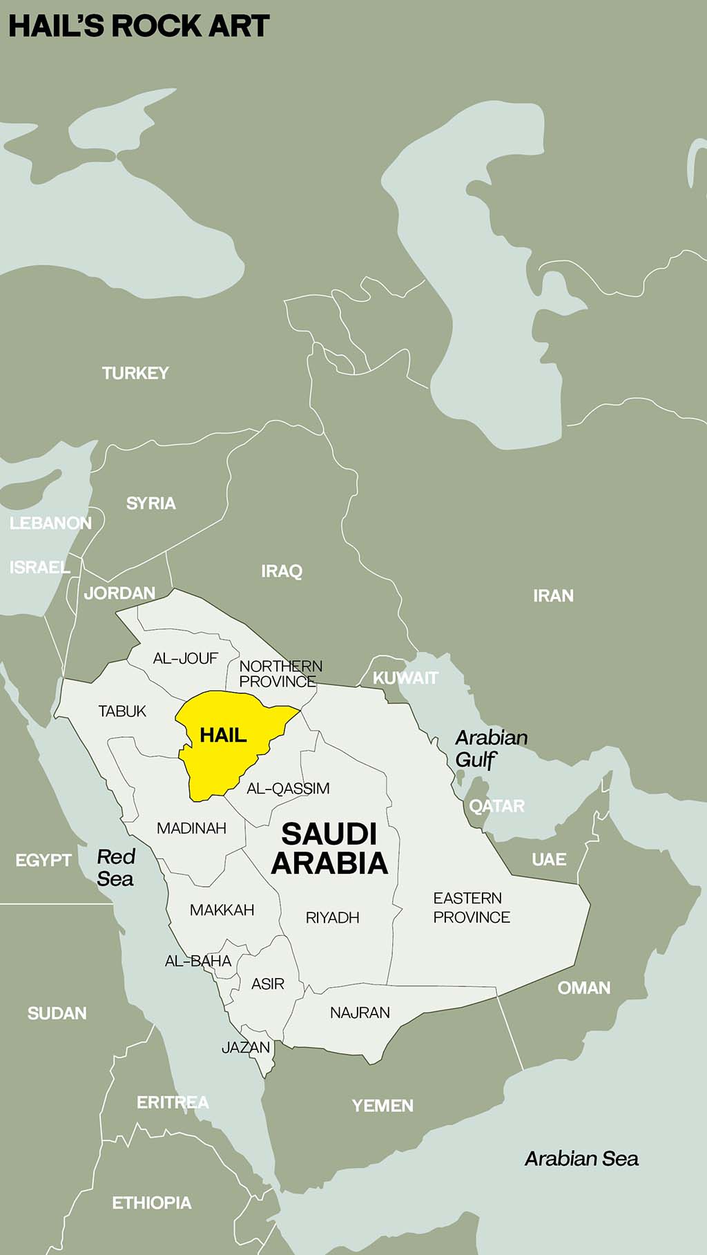
Hail: Rock art
Messages from an ancient past

On March 2, 1972, NASA’s Pioneer 10 probe blasted off from Cape Canaveral, bound for a brief rendezvous with the planet Jupiter and a one-way voyage to the edge of the solar system and the infinity beyond.
On board was a simple aluminum plaque, measuring just 22 by 15 centimeters. Created by the cosmologist Carl Sagan, it bore a series of simple pictorial messages designed to convey basic details about the nature and location in the universe of human life to any intelligent extraterrestrial being that might one day encounter the probe.
In both its design and intent, there is a striking similarity between the plaque and the designs carved by ancient peoples into the rocks of Saudi Arabia’s Hail region, a stunning collection of thousands of petroglyphs that together tell the story of almost 10,000 years of human history.
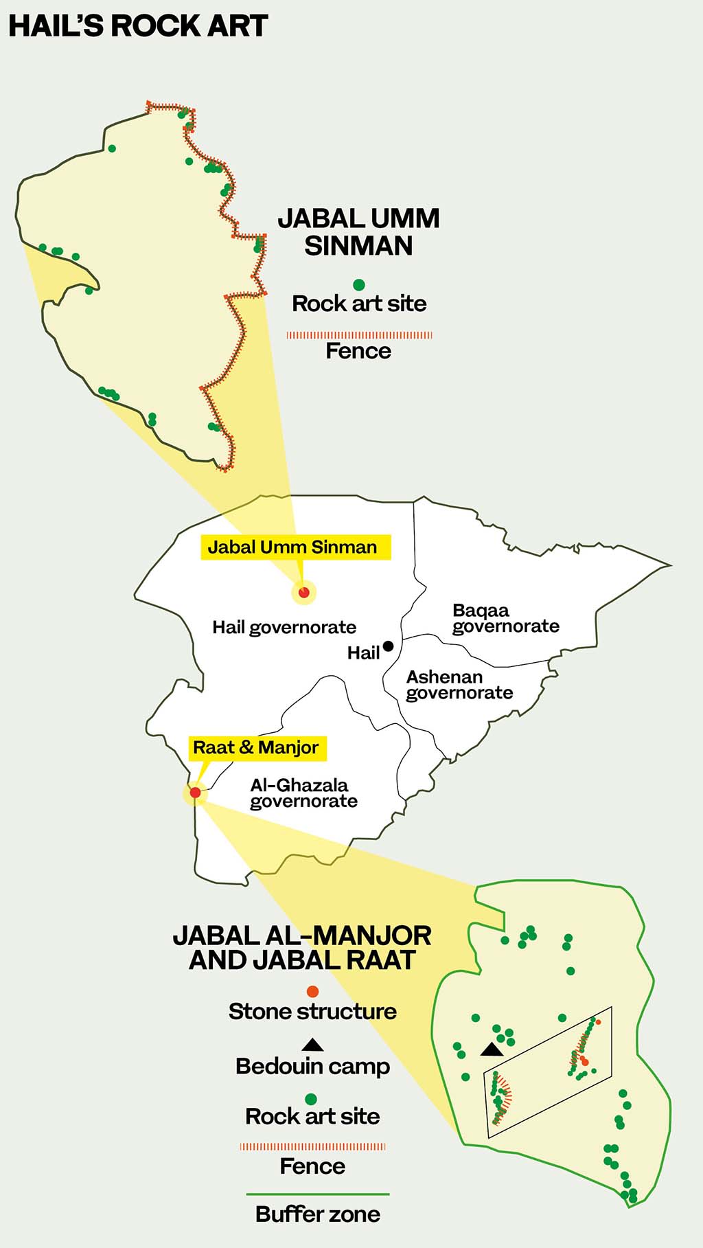
Adopted by UNESCO as a World Heritage Site of “outstanding universal value” in 2015, the world’s largest and most impressive collections of Neolithic petroglyphs, or rock carvings, can be found at two sites some 300 kilometers apart in the Hail province of Saudi Arabia.

The first is at Jabal Umm Sinman, a rocky outcrop to the west of the largely agricultural modern town of Jubbah, some 90 kilometers northwest of the city of Hail and 680 kilometers from the capital Riyadh. The town’s origins as an oasis date back to the dawn of Arab civilization, when the hills of Umm Sinman overlooked a freshwater lake, eventually lost beneath the sands of the surrounding Nefud desert some 6,000 years ago.
It was on these hills, in the words of the UNESCO nomination document, that the ancestors of today’s Saudi Arabians “left the marks of their presence, their religions, social, cultural, intellectual and philosophical perspectives of their beliefs about life and death, metaphysical and cosmological ideologies.”
The second site, which remarkably was discovered only 20 years ago, is at Jabal Al-Manjor and Jabal Raat, 220 kilometers southwest of Jubbah and near the village of Shuwaymis.

Jubbah, with 14 clusters of petroglyphs, was already regarded as the most significant site in the Arabian Peninsula. The discovery of the neighboring site near Shuwaymis, with a further 18 clusters, compounded the Hail region’s claim to possessing one of the world’s most significant collections of rock art, “visually stunning expressions of the human creative genius by world standards, comparable to the messages left by doomed civilizations in Mesoamerica or on Easter Island … of highest outstanding universal value.”
Together, the twin sites tell the story of over 9,000 years of human history, from the earliest pictorial records of hunting to the development of writing, religion and the domestication of animals including cattle, horses and camels.
As the UNESCO documents record, these sites justify their inscription on the World Heritage List not only because of their “spectacular environmental setting in the midst of a desert,” but also because they feature “large numbers of petroglyphs of exceptional quality attributed to between 6,000 and 9,000 years of human history, followed in the last 3,000 years by very early development of writing that reflects the Bedouin culture, ending in Quranic verses.”
Furthermore, the Jubbah and Shuwaymis sites comprise, among numerous other rock art and archaeological features, “the world’s largest and most magnificent surviving corpus of Neolithic petroglyphs.”
Neolithic rock art is found at many locations across Eurasia and North Africa, “but nowhere in such dense concentration or with such consistently high visual quality.”
Created in an age before writing, and painstakingly pecked, chiseled and engraved out of the sandstone rocks of the region, the rock art is a simple but vivid record of human existence that, like Sagan’s plaque meant for aliens, conveys the basic details of life on Earth at a moment in time.
Dr. Majid Khan, who, as one of the world’s leading experts on the rock art of Saudi Arabia, played a major role in the nomination of the twin sites for recognition by UNESCO, said the petroglyphs are as good as a written diary of humankind’s adaptation to the challenges of survival in an environment that changed dramatically over thousands of years.
“The rock art of Jubbah represents all phases of human presence from the Neolithic period — 10,000 years before the present time — until the recent past,” said Khan, who has published numerous books and papers on the subject and is a consultant to the antiquities department of the Saudi Ministry of Culture.
“The types of animals depicted suggest change in climate and environment. Large ox figures, for example, indicate a cool and humid climate, while the absence of ox figures and the appearance of camel petroglyphs represent hot and dry conditions.”
Over millennia, the heart of Arabia was transformed from a savannah-like wetland, through which lions roamed and rivers ran, until by about 3,000 BCE it had become the arid desert landscape familiar today, in which wadis, wells and precious, scattered oases became the keys to life.
The forebears of today’s Arabs clung on stubbornly to existence as the climate and the landscape changed around them. The astonishing petroglyphs that can be seen at Jubbah and Shuwaymis tell a story of human determination, ingenuity and adaptation in the face of a slow-moving but ultimately inexorable environmental disaster.
As the nomination document submitted to UNESCO by Saudi Arabia makes clear, the triumph of these early Arabs against near-impossible odds carries a special message of hope for a world today facing the looming prospect of climate change.
“The cultures that were responsible for the petroglyphs have adapted to changing climate and severely fluctuating water availability,” reads the UNESCO citation.
“As a library recording the interaction of successive societies with their volatile environment, subjected to desertification, lowering of aquifer, volcanic eruptions and the irreversible changes that characterize Arabia today, the rock art provides a unique testament.”
The art, “an exceptional record of human interaction with a deteriorating environment,” is nothing less than “a comprehensive demonstration of … resilience and determination in the face of catastrophic changes.”
At both Jubbah and Shuwaymis, the presence of the human beings who so dramatically left their mark on the world they left behind can be felt not only through their art but also through the crude tools discarded at the sites — hammer stones fashioned by, and last held in, human hands thousands of years ago.
Today, so long after they were created, no one can know for sure if the rock drawings were meant as messages for a distant future or whether they were intended only to serve both pragmatic and spiritual purposes for the people who created them.
Sandra Olsen, an American archaeologist who has studied the rock art at Jubbah and Shuwaymis in great detail, said some were perhaps territorial markers, while others may have been connected to the celebration of victories, the bounty of wildlife, the worship of long-forgotten gods or, in some cases, the product of the simple, essentially human need to leave a record of one’s existence — to affirm that “I was here.”
“As archaeologists, we mustn’t inflict our own cold, scientific, non-religious thoughts too much on what these people were doing, and we also shouldn’t try to over-interpret their religious beliefs,” she told Arab News.
“But I think it’s fairly safe to say that there are religious and spiritual purposes behind a lot of the art.”
US archaeologist Sandra Olsen on the secrets of Hail's rock art. (Richard T. Bryant)
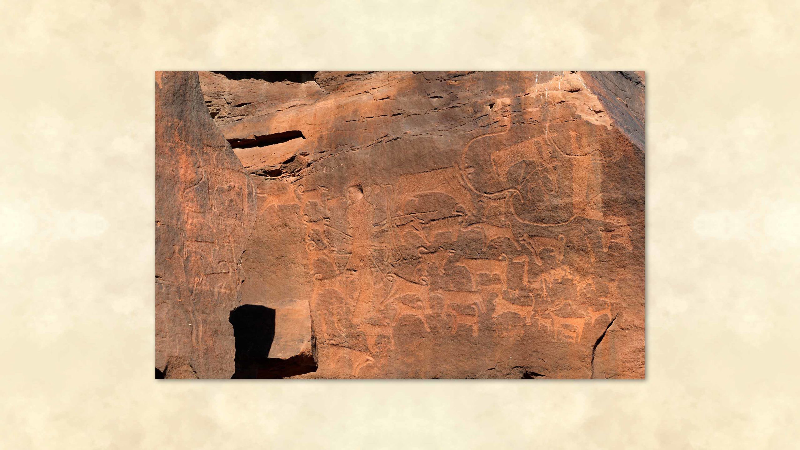
At Shuwaymis and Jubbah these ancient ones, frozen in time, are shown herding camels and cattle and hunting prey including lion, leopard and ostrich, armed with bows and arrows and aided by domesticated hunting dogs, portrayed as restrained on leashes. These images, showing what appear to be Canaan dogs, an originally wild and hardy breed tamed in ancient times by the Bedouin and still in existence today, are believed to be the oldest visual representation of humankind’s working relationship with “man’s best friend.”
There are also images of dancers, which, to Olsen’s delight, seemed to come alive when she and her team began using a range of different techniques to photograph the rock art between 2009 and 2011.
“We did half of our work at night, using a couple of different techniques, and when you focus the light just right you can see the images so much better at night than during the daytime.
“We had campfires, and when the firelight flickered on the rock art, it looked animated, like the figures were moving or dancing. It’s difficult to prove how the artists wanted their work to be seen, but I can tell you it’s much better seen by firelight than under a bright sun.”
One rock face at Jubbah bears witness to the adoption in the region of one of the key inventions of early humankind — the wheel, shown on a horse-drawn chariot and depicted not in profile, but as a schematic viewed from above.
This, Olsen believes, may have been a warning to outsiders. “It’s a style that is found from Sweden to Mongolia, all across the Eurasian steppes and down into Central Asia, India, North Africa and Arabia. I think it’s shorthand that means ‘This is our territory. We have chariots, we’ve conquered this land, and you’d better watch out.’”
But much of the art, she believes, was about celebrating and maintaining traditions. “You have to think about where they were located,” she said. “Some were placed like billboards, so everyone could see them. Others are in little niches, off the beaten path and perhaps more secret.”
In either case, much time and effort would have been dedicated to the creations, executed during a period in history when merely surviving would have been a full-time job. Intriguingly, said Olsen, there are also half-finished pieces, which seem to indicate that the artists behind them “sometimes just had to get up and leave and never quite got back to that spot.”
The fate of the artists who failed to return to their unfinished work can never be known. “Usually they would have returned, they would have traveled on certain routes, following large herds of animals through their migrations because they were hunters or because they had sheep, goats and cattle, and they had to move with them all the time.”
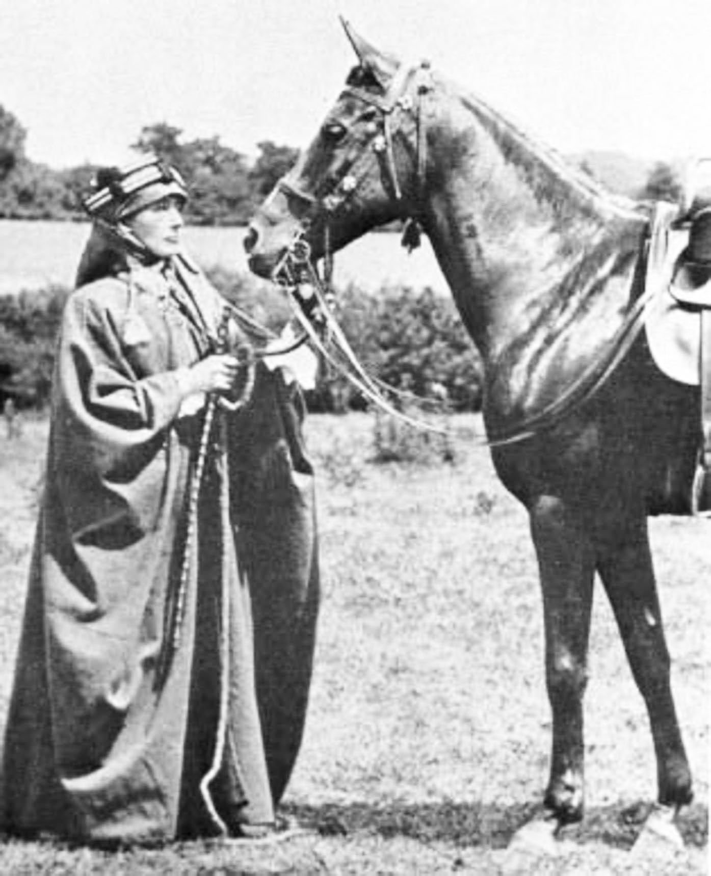
Although of course familiar to Bedouin tribespeople since time immemorial, the ancient carvings at Jubbah have only been known to antiquarians since their accidental “discovery” in the 19th century by two of the first Western travelers to visit the oasis. In 1879, Lady Anne Blunt, founder of an Arabian horse stud in England, passed through Jubbah with her husband, Wilfrid, on their way to purchase steeds in Hail.
On the rocks above the town, Wilfrid, an amateur archaeologist searching for evidence of early inscriptions, found instead what his wife dismissed in a memoir as “a few of those simple designs one finds everywhere on the sandstone, representing camels and gazelles.”
Those “simple designs” would later be recognized by UNESCO as being part of “the biggest and richest rock art complexes not only in Saudi Arabia, but in the Arabian Peninsula and the Middle East generally,” comparable with “the most fascinating and largest rock art sites of the world.”
According to Robert Bednarik, an Australian archaeologist and rock-art expert who worked with and co-authored a number of papers with Dr. Majid Khan and who visited the Shuwaymis site within months of its discovery, its 8,000-year-old Neolithic panels “are among the most spectacular rock art in the world.”
Indeed, as he wrote in the newsletter of the Australian Rock Art Research Association shortly after the Saudi sites were inscribed on the UNESCO World Heritage List in 2015, “the most outstanding Neolithic rock art known, comprising many thousands of painstakingly made magnificent figures, is that of the Shuwaymis sites.”
Although there is at least one larger complex among the 2,000 or more rock-art sites in Saudi Arabia, stretching from 50 to 130 kilometers north of the city of Najran, in the Kingdom’s southwest, “in terms of visual grandeur, Shuwaymis is unsurpassed.”
Remarkably, the secrets carved into rocks at Jabal Al-Manjor and Jabal Raat near the village of Shuwaymis remained unknown even to the Saudi authorities until 2001 — a testimony to the remoteness of their location in the inaccessible Harat Khaybar lava fields on the eastern flanks of the Hejaz mountain range.
The story of the discovery of what is now recognized as one of the largest and most important collections of ancient rock art in the world was told in a 2002 edition of Aramco World.
In March 2001, a camel herder told local schoolteacher Mahboub Habbas Al-Rasheedi about rock carvings he had seen while grazing his animals. Al-Rasheedi and his brother spent days exploring the area and “stumbled into a proliferation of rock art tableaux,” including images of humans, cheetahs, hyenas, dogs, cattle, ibex, horses, camels and ostrich.
The story, said Khan, is correct. “I met the Bedouin, Al-Rasheedi and the director of archaeology in the Hail region, who took us to the sites for further investigations and research,” he said.
What that revealed, according to a range of dating techniques, including analysis of the patina that forms on rocks over vast periods of time and the cultural artifacts found at the sites, was that “Shuwaymis is the oldest rock art site in the Kingdom, dating from 14,000 years before the present time.”
For Khan, who has visited and worked on both sites many times, “it was the most emotional moment of my 40 years of research when the sites were registered on the World Heritage list.”


Many rocks, such as this one near Shuwaymis, carry images of the bezoar, a wild goat that is rare in Arabia today but was once common across the peninsula. (Saudi Tourism)
Many rocks, such as this one near Shuwaymis, carry images of the bezoar, a wild goat that is rare in Arabia today but was once common across the peninsula. (Saudi Tourism)

Lady Anne Blunt, who came to Hail in 1879 with her husband Wilfrid in search of Arab steeds for their stud in England, was the first westerner to record the rock art at Jubbah. (Alamy)
Lady Anne Blunt, who came to Hail in 1879 with her husband Wilfrid in search of Arab steeds for their stud in England, was the first westerner to record the rock art at Jubbah. (Alamy)

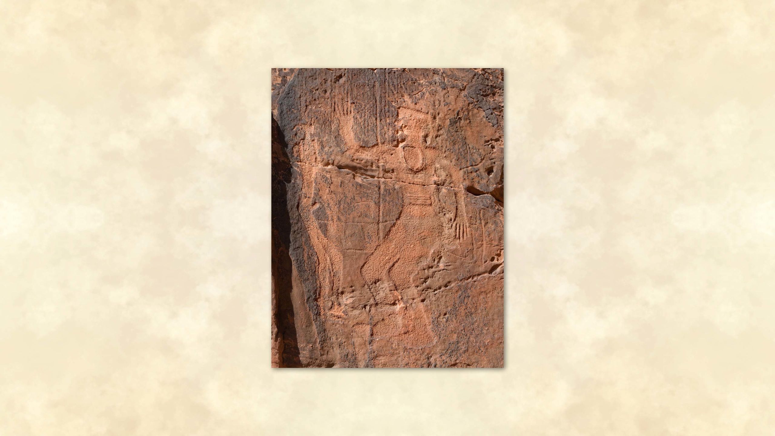


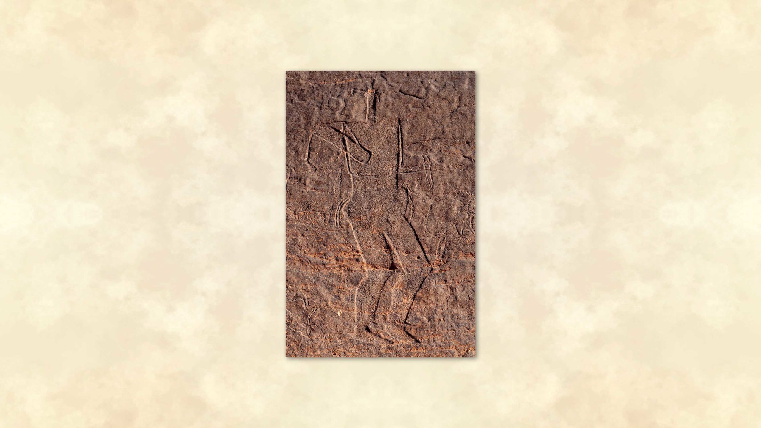


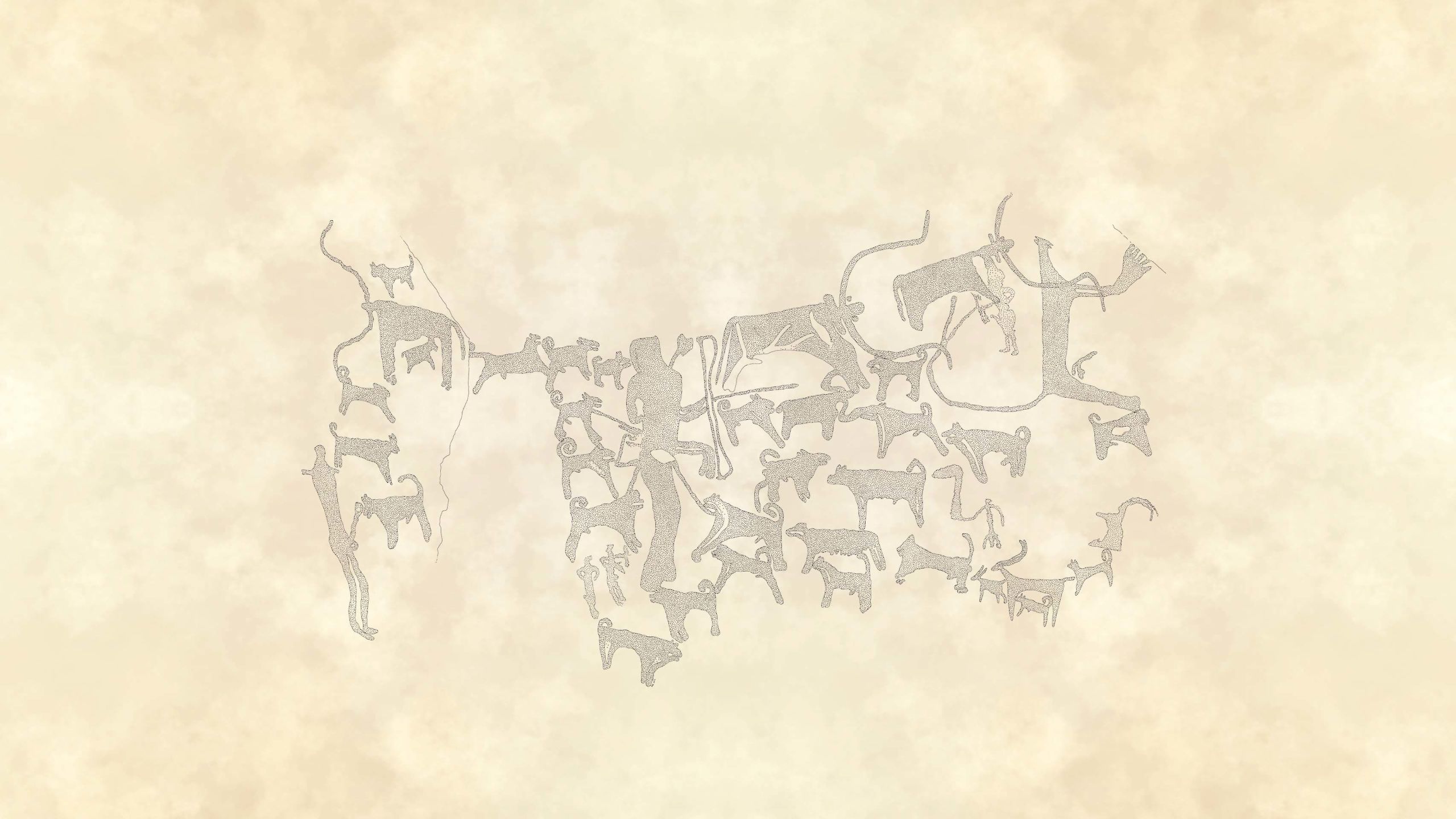

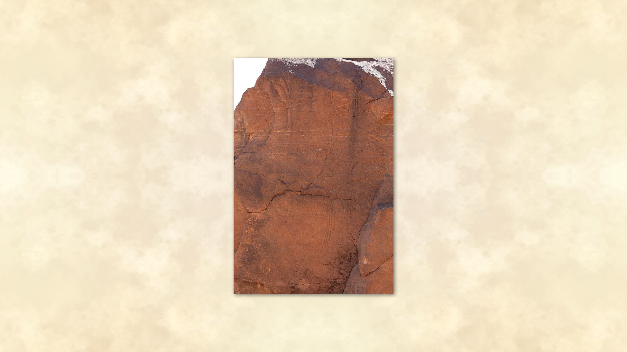

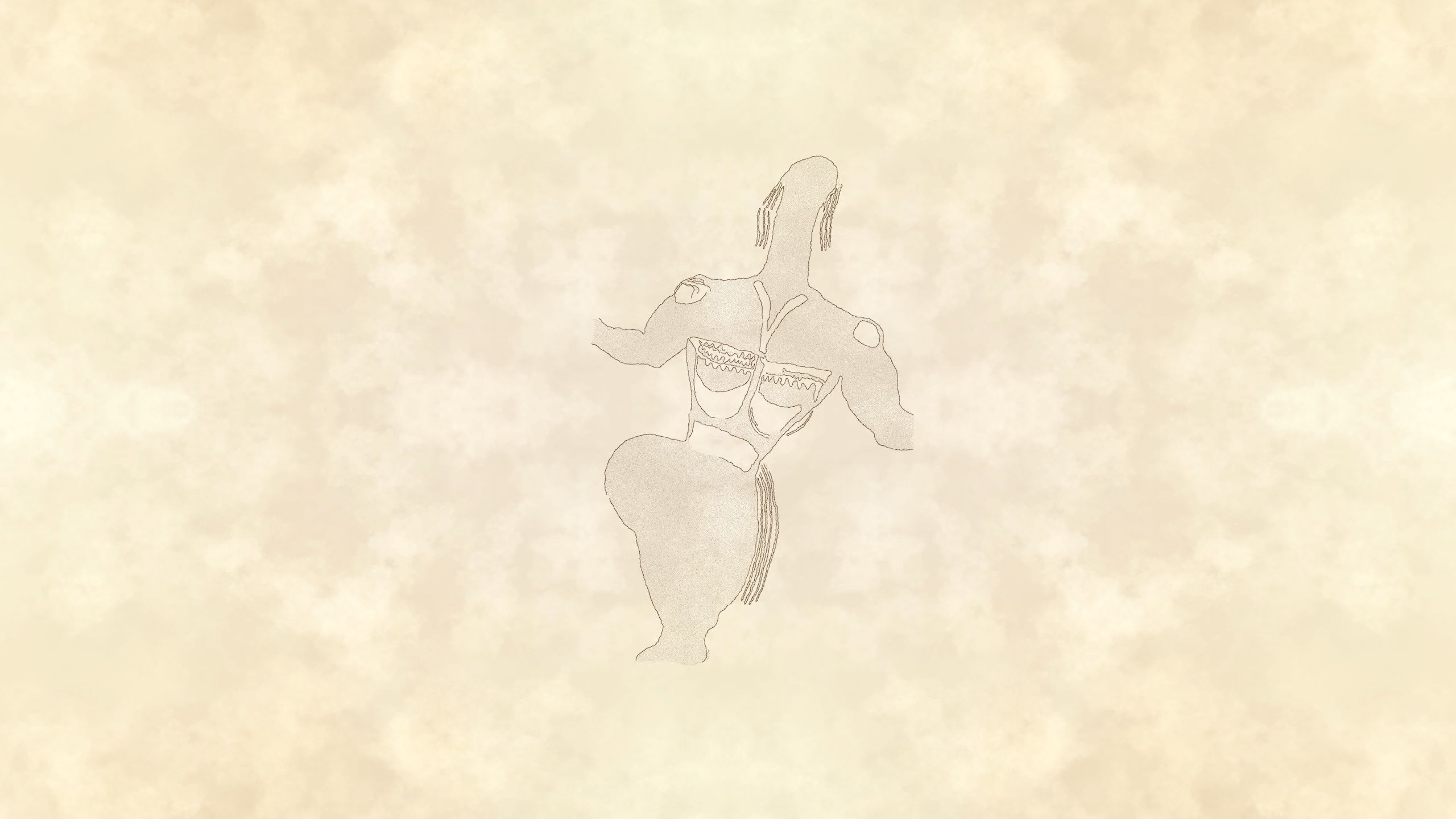

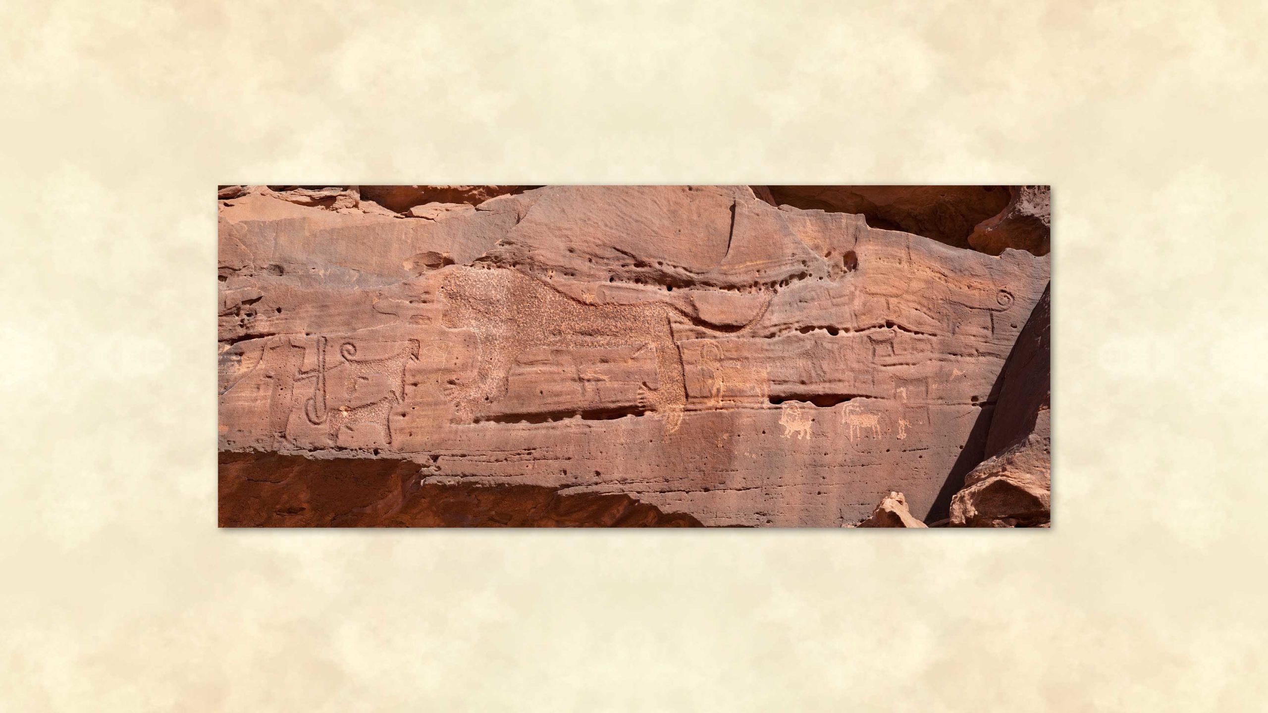


Graphic renderings by the artist Amanda Zimmerman bring out the details of the rock art. A figure known as The King and a warrior depicted at Jubbah. (Photos by Richard T. Bryant)
A hunter depicted with a bow and what might be a throwing stick at Jubbah.
This scene at Shuwaymis shows a man armed with a bow hunting with dogs.
This powerful carving at Jubbah shows a figure known as The Queen.
A Shuwaymis hunting scene is a reminder that lions once roamed a green Arabia.
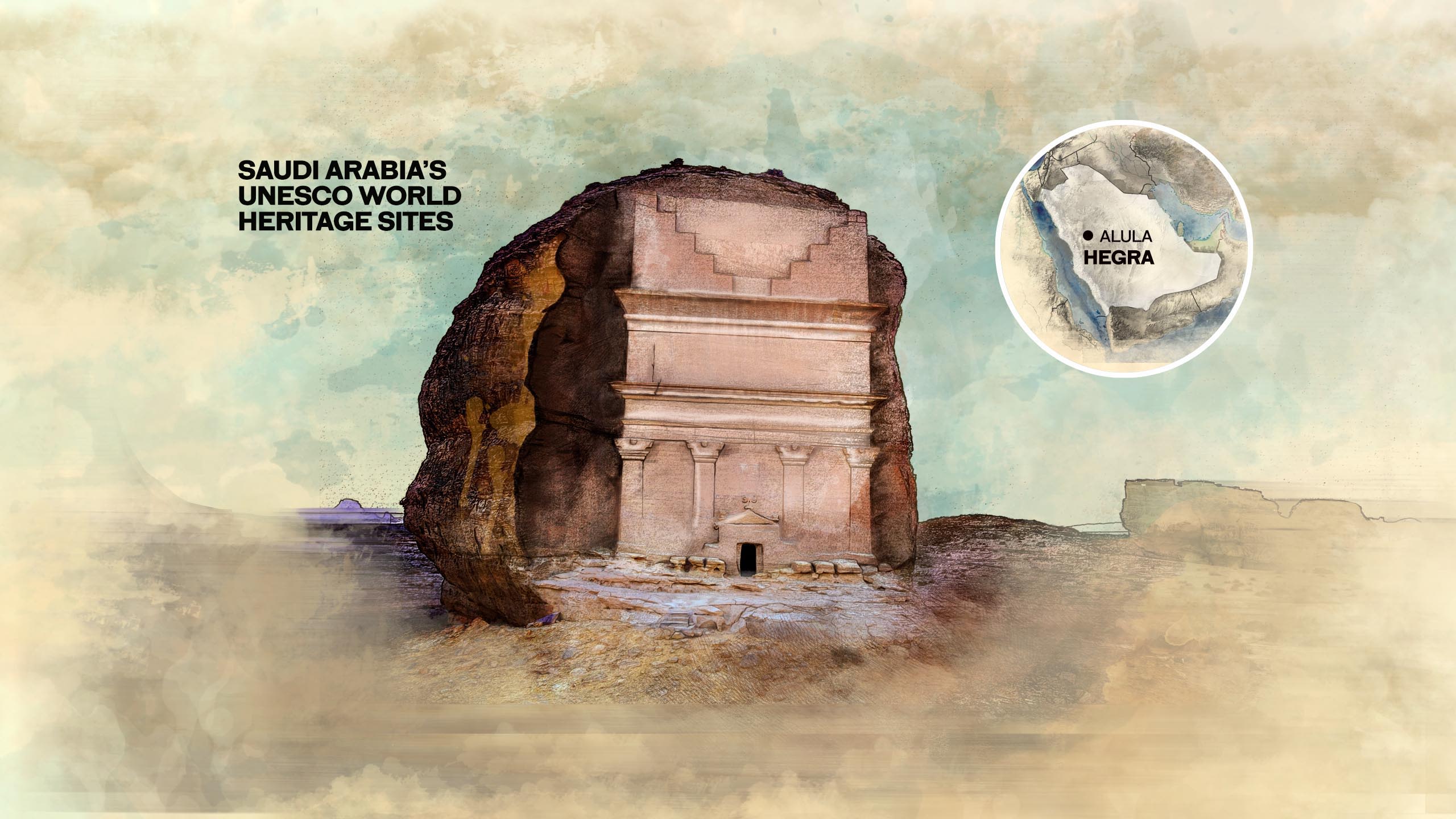
AlUla: Hegra
Ancient city of the Nabataeans

Petra, the ancient rock-carved city in modern-day Jordan, is famed throughout the world for its monumental ruins, left behind by the lost civilization of the Nabataeans. But Petra tells only half the story of this mysterious people whose empire of trade at its peak 3,000 years ago dominated Arabia for about two centuries.
Now, as Saudi Arabia opens up to global tourism, the world is invited to travel 500 kilometers south from Petra to discover the wonders of Hegra, its sister city, carved from the rocks in a remote valley that was once at the crossroads of international trade.
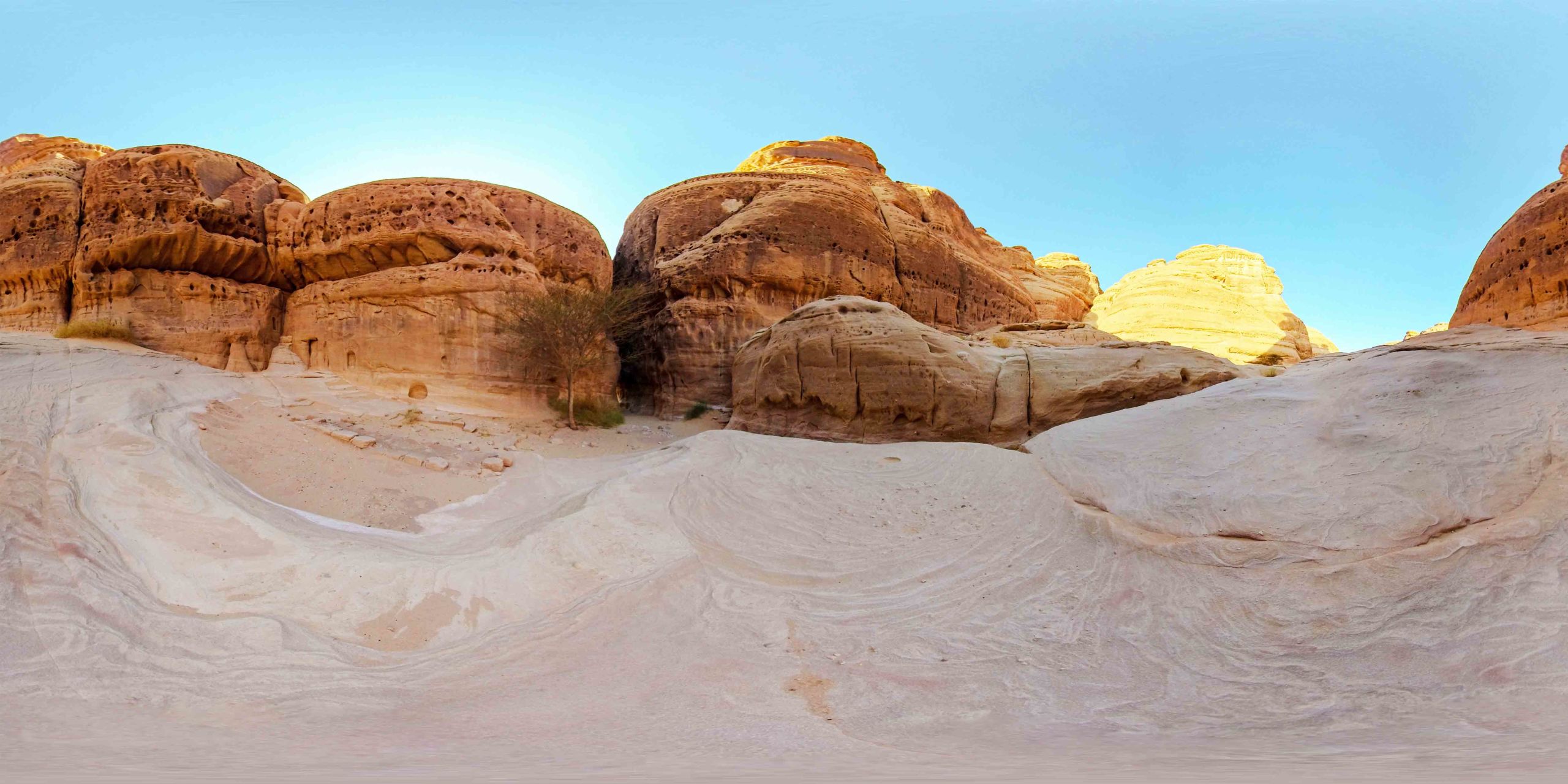
Some 200 kilometers inland from the Red Sea, Hegra is situated on a large plain southeast of the Hijaz Mountains, studded with hills of sandstone, isolated or grouped together to form massifs that have been dramatically sculpted by northwesterly winds, which have blown through the region every spring and early summer for millennia.
In addition to creating the monumental canvases upon which the Nabataeans carved their story, the winds have also formed strange and evocative shapes, such as the three-story rock 10 kilometers northeast of the modern town of AlUla, sculpted over millions of years to resemble an elephant.
Most of the monuments and inscriptions visible at Hegra date from the first centuries BCE to about 75 CE, but shards of pottery and other objects found recently at the site suggest that human settlement there began possibly in the third or second century BCE.
The earliest known historical reference to the Nabataeans was written in about 311 BCE by Hieronymus of Cardia, a Greek general and contemporary of Alexander the Great who took part in a series of failed attempts to defeat them.
Hegra, a place of superstition avoided by the Bedouin, was later known as Madain Saleh — or the city of Saleh — a place associated with an account in the Qur’an of a vain attempt by the Prophet Saleh to convert the Thamudi, a tribe in the AlUla Valley, from their idolatrous ways.
Archaeologists believe that it was the perception of Hegra by the Bedouin as a cursed place, unsafe for settlement by the living, that over the centuries has helped to preserve much of its fabric.
Hegra was “discovered” in the 1880s by the British explorer Charles Montagu Doughty, the first Westerner to visit the site. In his book “Travels in Arabia Deserta,” published in 1888, he recalled stumbling upon the lost monumental necropolis — a carved citadel of the dead, hewn out of the towering sandstone rock faces that surrounded the site of an old city.
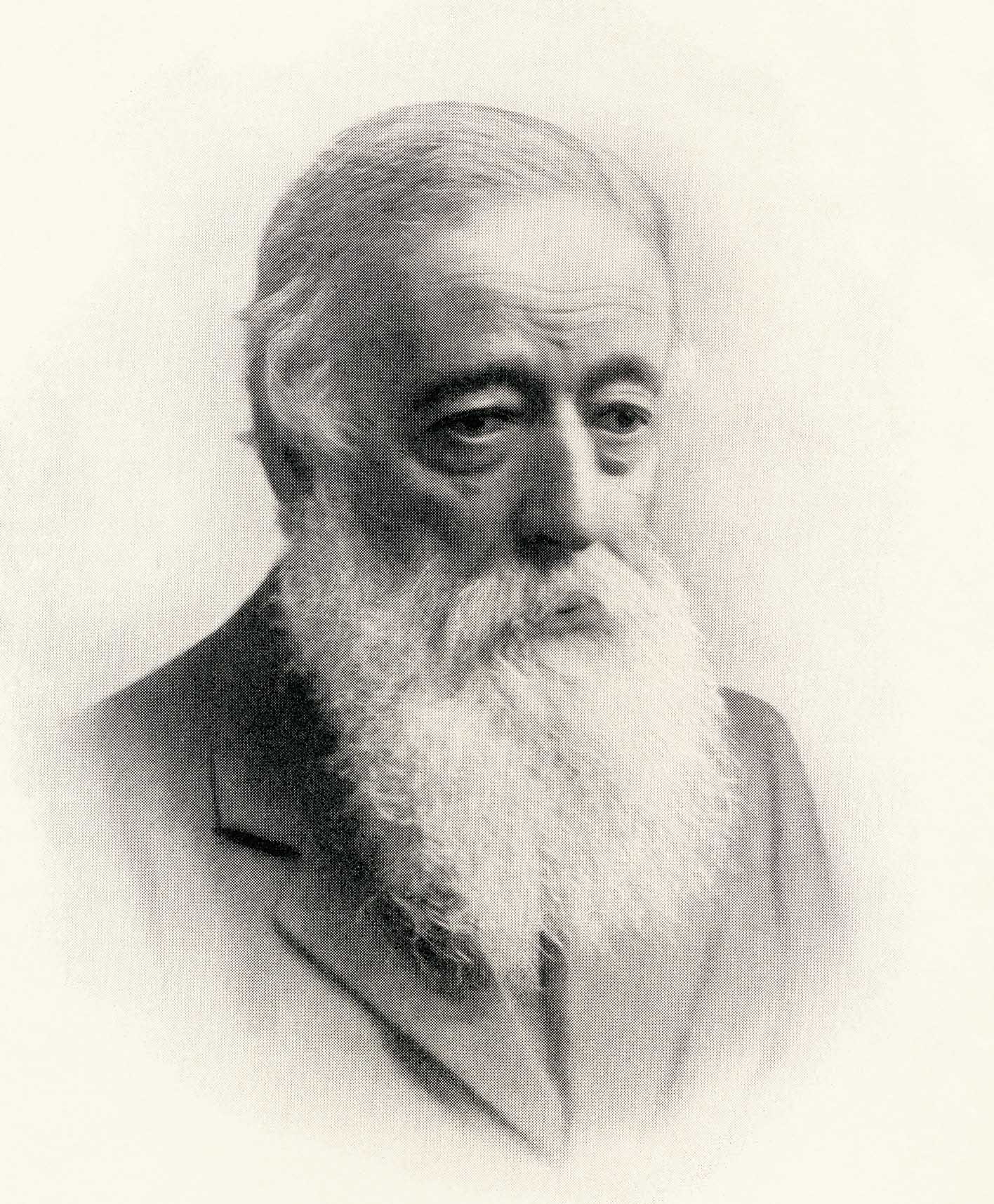
“Little remains of the old civil generations of el-Héjr, the caravan city,” Doughty wrote. “Her clay-built streets are again the blown dust in the wilderness. Their story is written for us only in the crabbed scrawlings upon many a wild crag of this sinister neighbourhood, and in the engraved titles of their funeral monuments, now solitary rocks, which the fearful passenger admires, in these desolate mountains.”
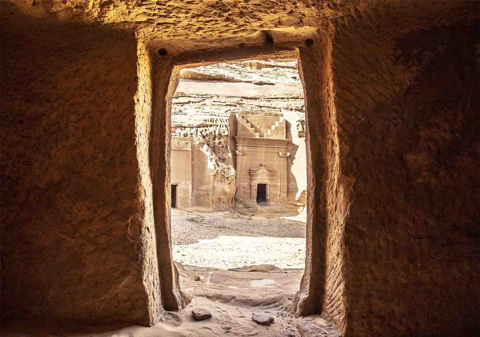
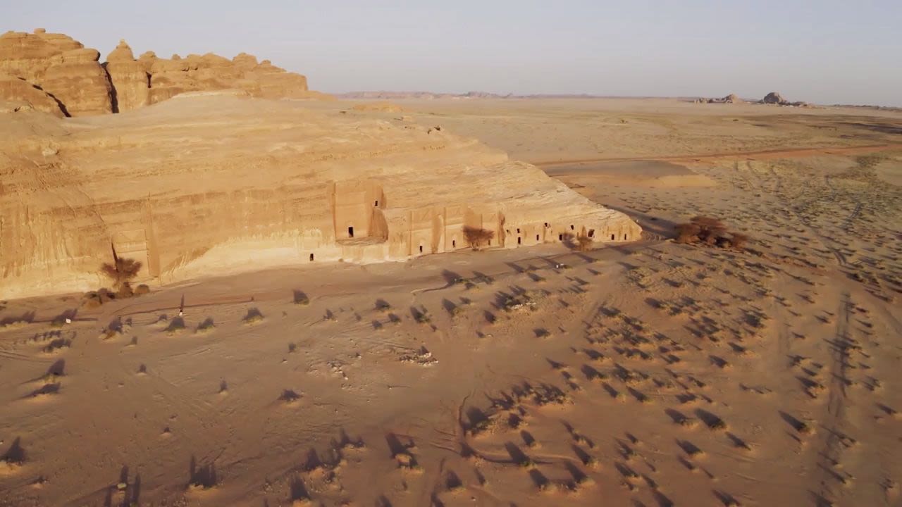
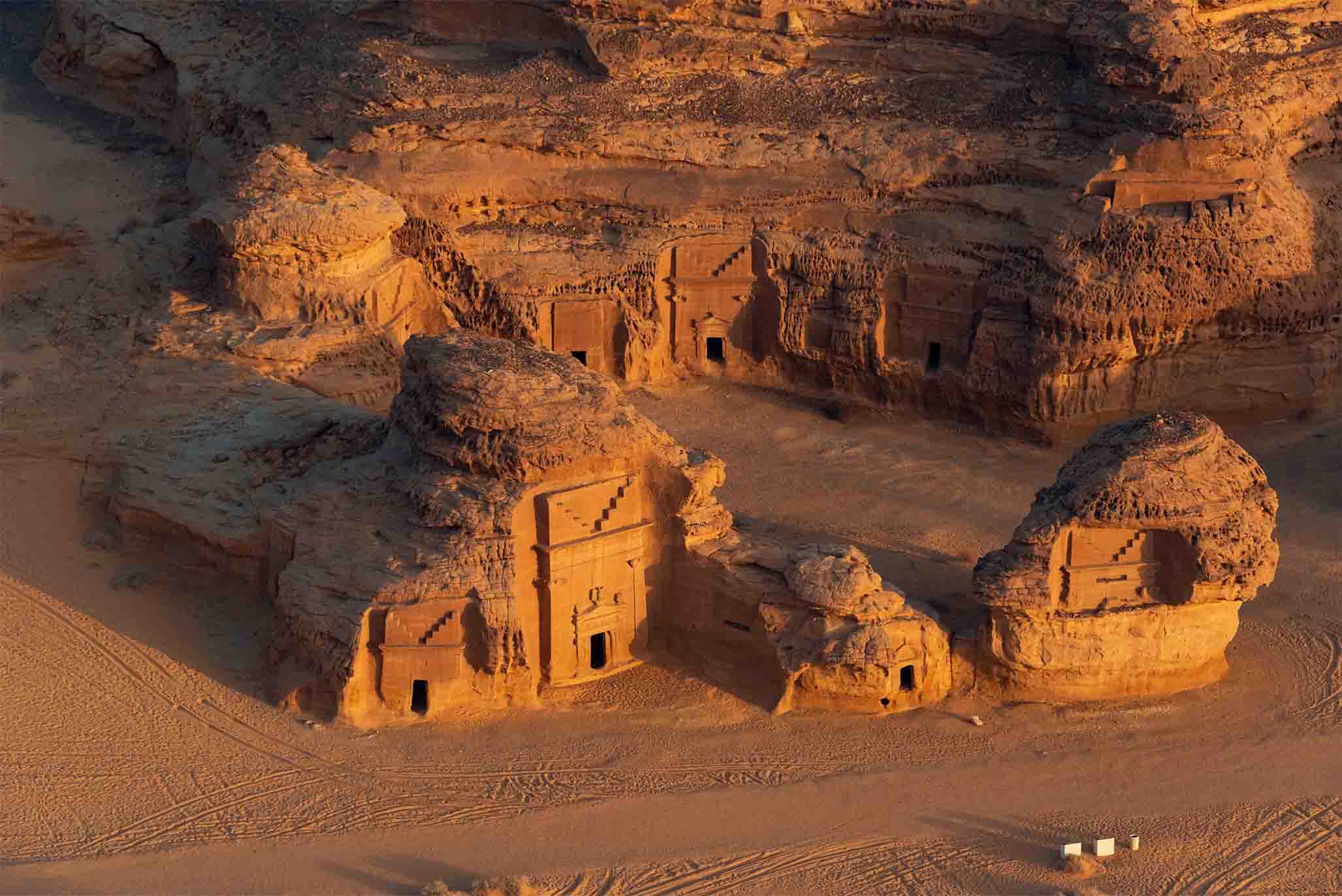
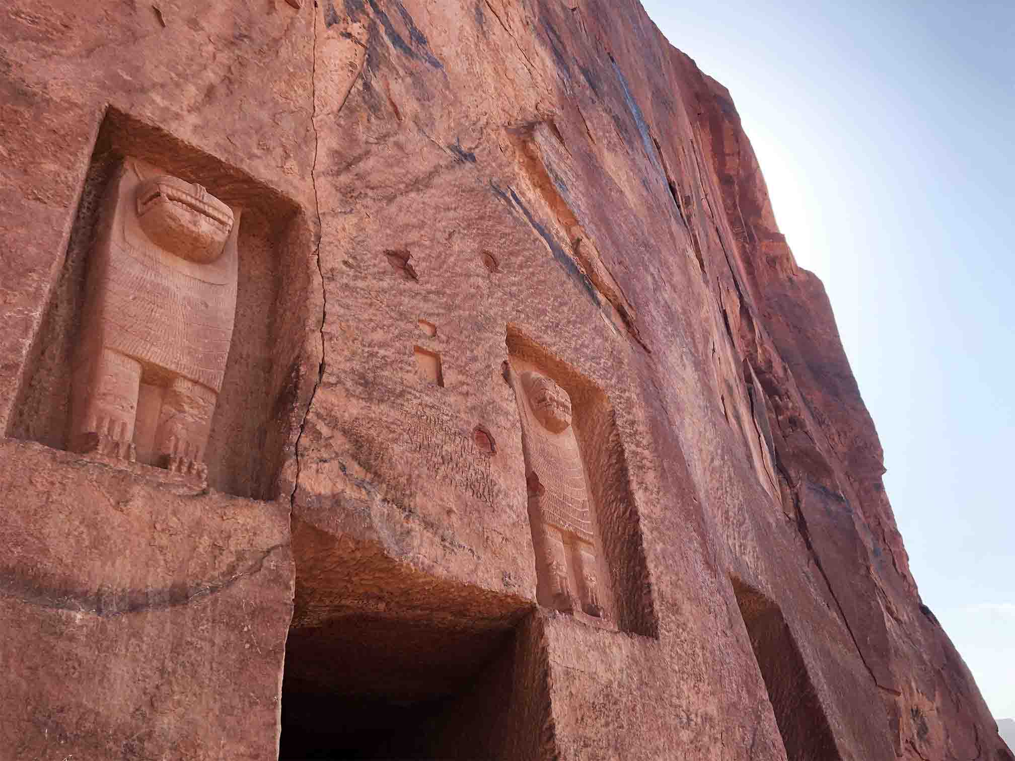
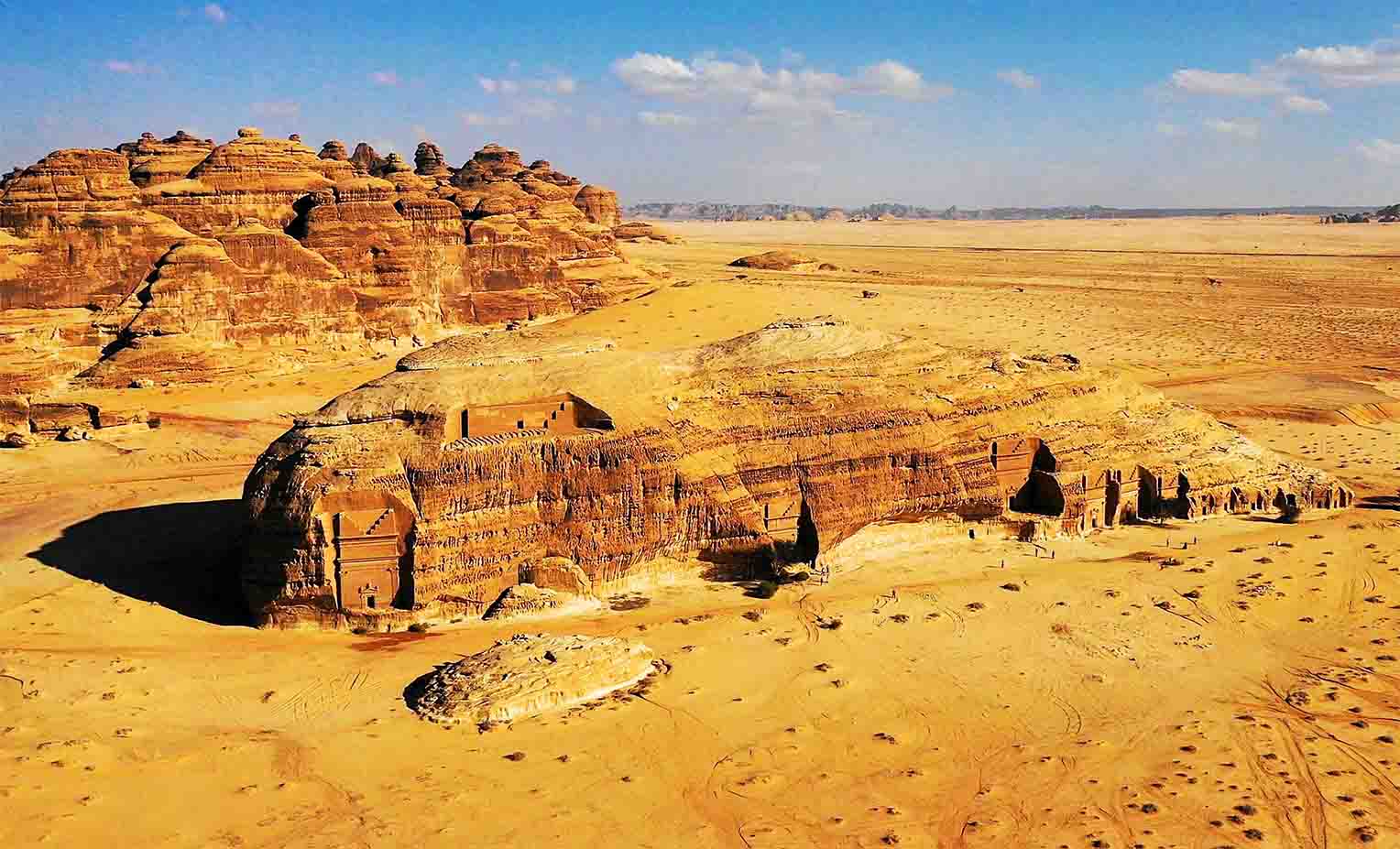
There are more than 100 monumental tombs carved out of the rocks at Hegra, dating from about the first century BCE to 75 CE. Of the four main necropoles, Qasr Al-Bint, the site of 31 tombs, is visually the most dramatic, both from a distance and up close. The exterior facades of many of the tombs feature carved monsters, eagles, and other small, sculpted animals and human faces.
As at Petra, many of the tombs feature spectacular carved facades. However, unlike at Petra, many carry Nabataean inscriptions, in some cases naming the dead and offering a unique insight into the lives of the people who once called Hegra home.
In addition to the rock tombs, more than 2,000 other burial places are scattered across the site.
Close by is the Jabal Ithlib — at 100 meters, the highest sandstone outcrop on the site. Here there are no tombs, but this was nevertheless a religious area, studded with niches, altars and sacred stone carvings, many of which bear inscriptions. Hewn out of the interior of the rock is a “triclinium,” a three-sided room where worshippers would have gathered for ritual meals.
Little can be seen today of the homes of the Nabataeans at Hegra. Made from sun-dried mud bricks, they have long disappeared beneath the sands, although geophysical surveys carried out between 2002 and 2005 revealed tantalizing evidence of underground structures. Parts of the city wall can still be made out.
Since Doughty’s visit, Hegra has been little known outside of academic circles. But now the ancient trading center has been awakened from a 1,600-year slumber. After one of the most exhaustive archaeological investigations ever carried out, it is once again welcoming visitors from around the world as the heart of a spectacular tourism development, focused on culture and heritage, that is restoring the AlUla Valley to its ancient status as a global destination.
“Hegra was my introduction to Saudi Arabia,” said architect Simone Ricca, a heritage conservation expert who helped prepare Saudi Arabia’s successful application to have the city listed in 2008 as a UNESCO World Heritage Site. In all, Ricca went on to work on the nominations for four of the Kingdom’s UNESCO sites.
“I visited for the first time in 2006,” recalled Ricca, co-founder of Paris-based RC Heritage consultants. “Thanks to a pioneering effort by the Saudi antiquities department to survey and protect the country’s sites in the early 1980s, there was a protective fence around the site. But there was no one there then.
“It was an incredibly fascinating experience. I had been to Petra, and I had been living and working in the Middle East for a few years, but I didn’t know much about Saudi Arabia.”
Ricca had seen a photograph of one of Hegra’s tombs hanging on the wall of a UNESCO office but never imagined he would go there. Then one evening, with the rocks and the desert lit by the light of a full moon, he did.
“It was so exciting,” he said. “I had this feeling, admittedly naive, of discovering something. I know it is stupid and childish. But part of my work is the privilege of visiting places that are not yet well known, and this was incredible.”
Hegra features a stunning collection of well-preserved monumental tombs dating from the first century BCE. The site, which features some 50 inscriptions of the pre-Nabataean period and cave drawings, is also home to dozens of ancient water wells. It was these, tapped by the Nabataeans’ innovative hydraulic expertise, that in antiquity transformed the AlUla Valley into a thriving oasis, a vital artery of caravan trade in incense and spices from Yemen and India.
Farming continues in AlUla today, just north of Hegra, where modern farms rely on the same underground water supplies that sustained the Nabataeans and even continue to use some of the old wells.
Mystery surrounds the origins of the Nabataeans, a people who for 400 years commanded a vast kingdom that in size and scope foreshadowed that of Saudi Arabia and whose written language was one of the final steppingstones in the evolution of Arabic. There is no mention of them in any written source before they first appeared in the account by Hieronymus of Cardia in 311 BCE.
Although most of the tombs at Hegra were carved and used between the first and early fourth centuries, occupation of the site dates from about the fourth century BCE. There is growing evidence that the Nabataean presence at Hegra may have continued in some form well into the fourth century, but their grip on the region and its profitable trade routes was ended suddenly in 106 CE, when the whole of their territory was overrun by the legions of Emperor Trajan and subsumed into the Roman province of Arabia Petraea.
Until the recent archaeological investigations at Hegra and throughout the wider AlUla Valley, there was no evidence to suggest that Rome’s influence in Arabia had extended much further south than the mouth of the Gulf of Aqaba on the Red Sea. But the discovery of a fortified Roman camp on the southern boundary of the ancient city is just part of the astonishing story that has emerged over the past decades, thanks to the work of a joint Saudi-French archaeological team whose trowels have swept away the sands of time that had obscured the world heritage treasure that is Hegra for two millennia.
The discovery, said Ricca, had redrawn the map of the Roman empire.
“No one knew that the Roman presence extended so far south in Arabia. The discovery of the fortress has added to the understanding that ancient Saudi Arabia was not an isolated place but part of the wider world.”
The AlUla Valley is home to a second fort, a reminder of another empire that came and went in Arabia. Between 1744 and 1757, the Ottomans built a fortress there to protect travelers on the old pilgrim route from Damascus and beyond to Makkah, which passed through the valley. The fort was built near the well of Bir Al-Naqa, where pilgrims travelling along the Syrian pilgrimage route also used to halt on their way to and from Makkah.
Nearby is a railway station, a stop on the Hejaz railway that was built by the Ottomans and ran 1,300 kilometers from Damascus to Madinah. Work began in 1901, and the railway opened in 1908, but it fell into disuse after the First World War, during which it was repeatedly attacked by the Arab warriors of the Hejaz who rebelled against Ottoman rule. Their exploits, fighting alongside the British liaison officer T.E. Lawrence, were immortalized in the 1962 movie Lawrence of Arabia.
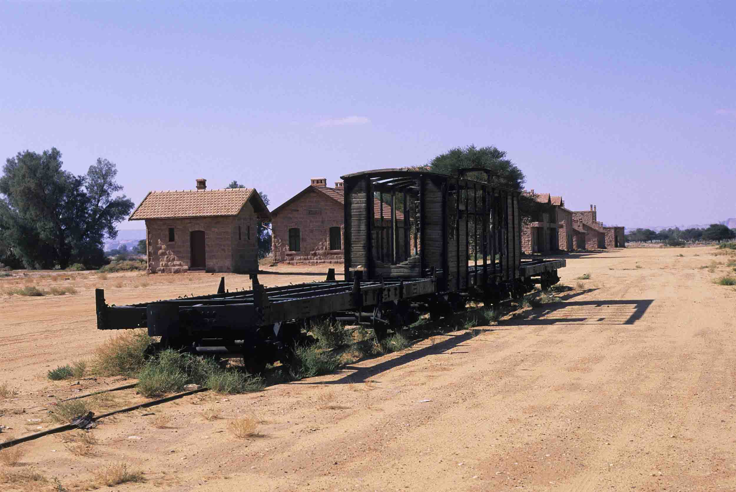
The remains of carriages and locomotives, blown off the tracks during the war, can still be seen in the desert. The restored station complex at AlUla now houses a museum and facilities for visitors.
In the words of the UNESCO document, the Hejaz railway “is historically important for both Arab and Turkish history as it marked the beginning of Arab autonomy and the end of the Ottoman Empire.”
Although not part of the UNESCO listing, other fascinating sights await visitors to the AlUla Valley. Some 20 kilometers south of Hegra are the ruins of the old town of AlUla, a complex of narrow passageways and now mainly roofless buildings, made of mudbrick and stone. Finally abandoned in the 1980s, this ghost town of some 900 tightly packed houses was for hundreds of years a bustling waypoint on the pilgrimage route to Makkah.
On its doorstep is the ancient city of Dadan, situated on the edge of a lush oasis of palm trees, where inhabitants of the old town would go to escape the heat during the summer months. The stone-built capital of the Dadan and later Lihyan kingdoms is believed to date back to between the late ninth and early eighth century BCE.
In 1326, the famed Moroccan traveler Ibn Battuta journeyed through old AlUla town by camel. His reflections on the hospitality of its inhabitants are recalled on a modern sign on the town’s ancient watchtower.
AlUla, he wrote, “is a large and fine village with orchards, dates, palms and water. The pilgrimage caravan stays there for four days to resupply and wash. Pilgrims leave any excess belongings they might have with the townspeople who are known for their trustworthiness and only take with them what they need.”
The abandoned city of AlUla occupies a significant place in the story of Islam. It is believed that in 630, the Prophet Muhammad passed through the town on his way from Madinah to the Battle of Tabuk.
Although it is not clear when the town was first built, it certainly dates back to the 13th century and was inhabited until 1983, the year the last family left for the new and modern town of AlUla nearby.
The whole of Hegra’s past is now playing a vital role in the future of the AlUla Valley. The Royal Commission for AlUla, established in 2017, worked in partnership with Afalula, the French Agency for AlUla Development, which was founded in Paris in July 2018 with the mission “to support its Saudi partner in the transformation of the AlUla region into a worldwide cultural and touristic destination.”
In an interview in February 2019, Amr Al-Madani, CEO of the Royal Commission for AlUla (RCU), described the plan for AlUla as “one of the Kingdom’s flagship projects,” designed “to promote the heritage of this region, to transform AlUla into one of the country’s cultural capitals.”
It was the vision of the commission and its French partner that AlUla would be transformed into a “living, open museum,” complete with a unique network of museums, archaeological sites and luxury hotels.
In addition to the treasures of Hegra, AlUla offers visitors resorts, hotels and other world-class facilities. About a 45-minute drive from Hegra is the Sharaan Nature Reserve, a 925-square-kilometer territory within AlUla county that features some of the region’s most striking rock formations and desert habitats, and is home to several luxury resorts.
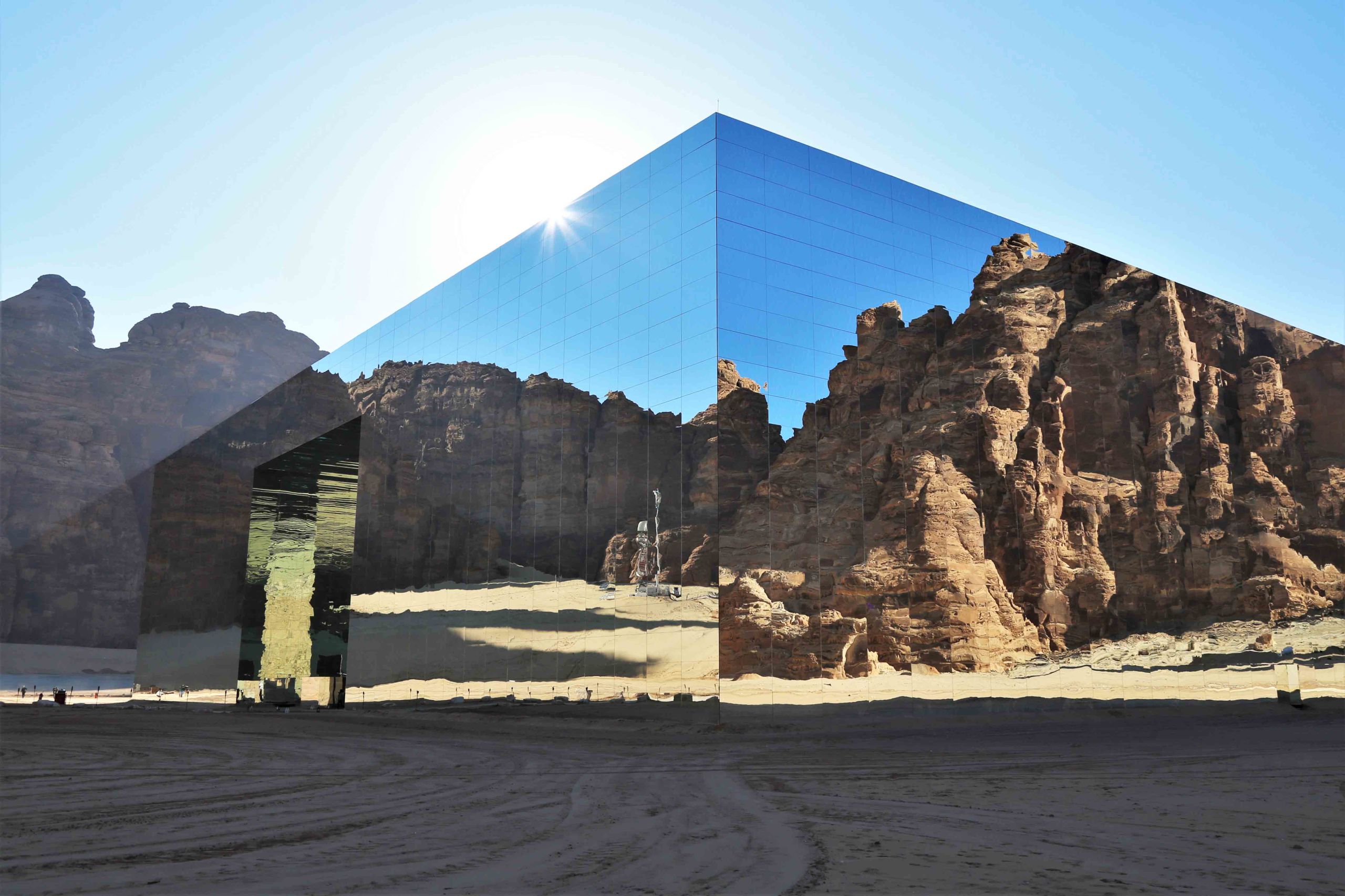
Elsewhere is the Maraya Concert Hall, a giant mirrored cube designed by Studio Gio Forma. In addition to its role as a concert venue and exhibition center, Maraya, which means “reflection” in Arabic, is a mesmerizing piece of art in its own right, its mirrored walls designed to create a visual extension of the breathtaking AlUla landscape.
Art and cultural initiatives are central to AlUla’s vision, as typified by the annual Winter at Tantora festival. The festival, which derives its name from a sundial located in the old town of AlUla, was staged for centuries by the locals to mark the changing of the seasons. In December 2018, it returned, greatly magnified, with a series of concerts over eight weekends featuring world-class musicians, revealing the destination of AlUla to the rest of the world. The RCU also commissioned artists to create public artworks inspired by AlUla.
As it shone in antiquity, so the AlUla region and its architectural treasures are now part of a bright future, for Saudi Arabia and the wider world.
“AlUla is an opportunity for the entire globe,” said Al-Madani. “It is a site for the development of knowledge, not just for Saudi Arabia but the entire international community.”
Just as the caravans of antiquity once came to trade in this land, so AlUla, ancient Hegra reborn, is once again attracting travelers from all corners of the world.

Of the 100 or more tombs carved into the rocks of Hegra, the majority are adorned with decorated facades while a third carry Nabataean inscriptions. (Saudi Ministry of Tourism)
Of the 100 or more tombs carved into the rocks of Hegra, the majority are adorned with decorated facades while a third carry Nabataean inscriptions. (Saudi Ministry of Tourism)

British explorer Charles Montagu Doughty, the first Westerner to reach Hegra, recorded his impressions of the Nabataean tombs in his book “Travels in Arabia Deserta,” published in 1888. (Getty Images)
British explorer Charles Montagu Doughty, the first Westerner to reach Hegra, recorded his impressions of the Nabataean tombs in his book “Travels in Arabia Deserta,” published in 1888. (Getty Images)

Thirty-one tombs dating from 1 to 58 CE are carved into Qasr Al-Bint, one of the spectacular necropoles at Hegra. (Getty Images)
Thirty-one tombs dating from 1 to 58 CE are carved into Qasr Al-Bint, one of the spectacular necropoles at Hegra. (Getty Images)

Carved monsters, human faces, eagles and other small sculpted animals decorate some of the tombs at Hegra. (Saudi Ministry of Culture)
Carved monsters, human faces, eagles and other small sculpted animals decorate some of the tombs at Hegra. (Saudi Ministry of Culture)

Hegra is situated in a large plain studded with sandstone outcrops. The most impressive of these is Jabal Ithlib, an ancient religious site home to a series of sanctuaries, niches and altars carved out of the rock. (Royal Commission for AlUla)
Hegra is situated in a large plain studded with sandstone outcrops. The most impressive of these is Jabal Ithlib, an ancient religious site home to a series of sanctuaries, niches and altars carved out of the rock. (Royal Commission for AlUla)

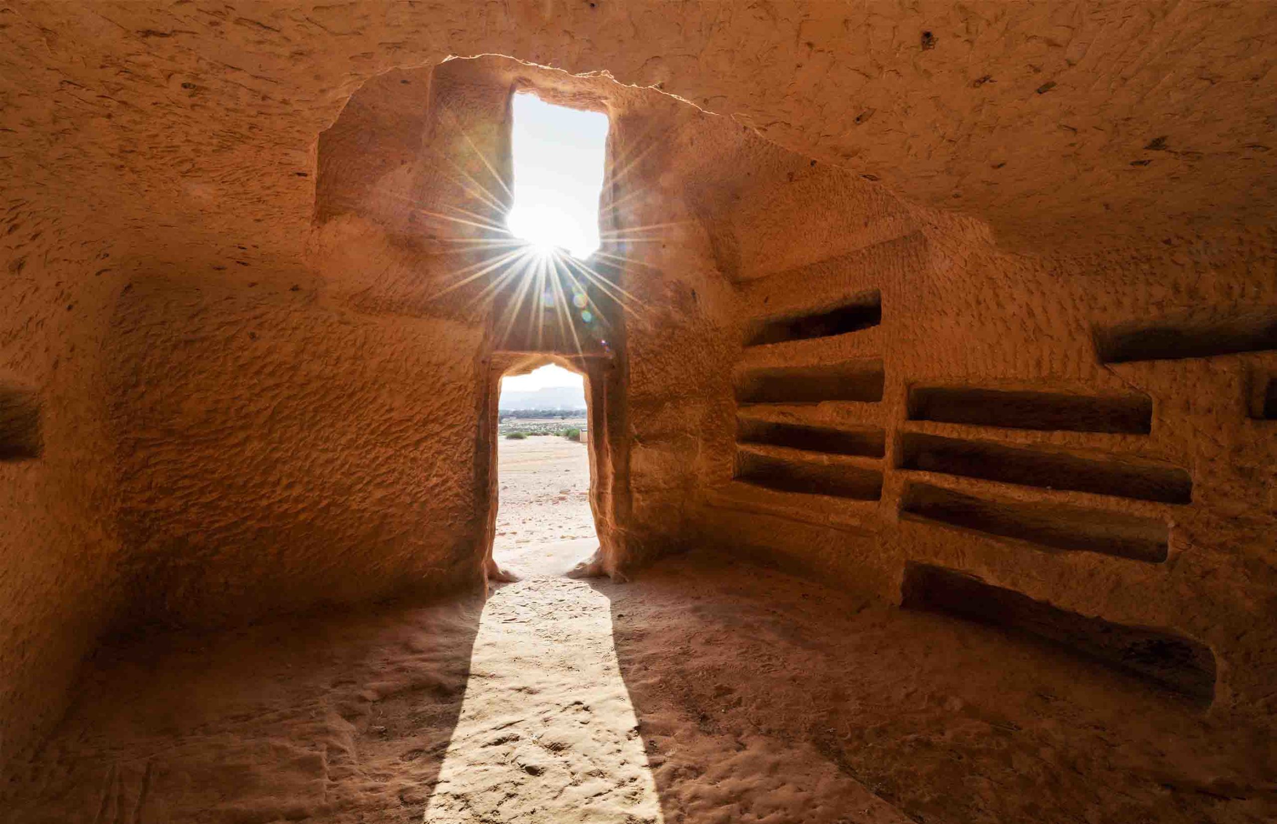
Inside one of Hegra’s many tombs. One, at Jabal Al-Ahmar, dates to 60 CE and was built for “Hinat daughter of Wahbu ... and for her children and her descendants forever ... In the twenty-first year of King Maliku, King of the Nabataeans.” It was found to contain the remains of more than 80 people. (Royal Commission for AlUla)
Inside one of Hegra’s many tombs. One, at Jabal Al-Ahmar, dates to 60 CE and was built for “Hinat daughter of Wahbu ... and for her children and her descendants forever ... In the twenty-first year of King Maliku, King of the Nabataeans.” It was found to contain the remains of more than 80 people. (Royal Commission for AlUla)

Hegra is also home to a station and the remains of the old Hejaz railway, built by the Ottomans to transport pilgrims from Damascus to Madinah. Opened in 1908, it was abandoned after being repeatedly attacked during the First World War. (Getty Images)
Hegra is also home to a station and the remains of the old Hejaz railway, built by the Ottomans to transport pilgrims from Damascus to Madinah. Opened in 1908, it was abandoned after being repeatedly attacked during the First World War. (Getty Images)

The protected site of Hegra lies within the AlUla Valley, which is being developed as a major cultural tourism destination, featuring resorts, festivals and the spectacular Maraya Concert Hall, the world’s largest mirrored building. (Royal Commission for AlUla)
The protected site of Hegra lies within the AlUla Valley, which is being developed as a major cultural tourism destination, featuring resorts, festivals and the spectacular Maraya Concert Hall, the world’s largest mirrored building. (Royal Commission for AlUla)
Al-Faw archaeological area
The birthplace of Saudi archaeology


Situated in the southwest of Saudi Arabia, 450 km inland from the Red Sea and separated from the vast Empty Quarter desert by the sandstone outcrops of the Tuwayq escarpment, is one of the most remarkable archaeological sites in the entire Arabian Peninsula.
Inscribed on UNESCO’s World Heritage List in 2024 as “The Cultural Landscape of Al-Faw Archaeological Area,” the 4,800-hectare site spans tens of thousands of years of human history, from the early Stone Age up to about the fifth century.
According to Simone Ricca, a heritage conservation expert who worked on the UNESCO nomination document with the Saudi Ministry of Culture, Al-Faw has two unique claims to fame.
“Al-Faw is probably the most important archaeological site in the Kingdom,” he said.


The remains of the ancient caravan city of Qaryat al-Faw. (Thomas Creissen)
The remains of the ancient caravan city of Qaryat al-Faw. (Thomas Creissen)
“It is the most complete site covering the longest period and, being at the crossroads of north-south and east-west trade routes, it was particularly significant for a very long (time) in history.”
And, for Saudi Arabian archaeologists, the site has very special meaning.
It was rediscovered in the early 20th century by engineers prospecting in the area for signs of oil. Archaeological work, led by Prof. Abdulrahman Al-Ansary of King Saud University in Riyadh, began in 1972, and what is known today is the product of half a century of exhaustive investigations by generations of Saudi archaeologists.
“Ansary was the father of Saudi archaeology,” said Ricca, director and co-founder of RCH, a French-based consultancy specializing in world heritage preservation.
“Al-Faw is the birthplace of Saudi archaeology and for 50 years has been a training ground for the students of archaeology from Riyadh.”


The souk at the heart of the ancient city of Qaryat al-Faw. (Thomas Creissen)
The souk at the heart of the ancient city of Qaryat al-Faw. (Thomas Creissen)
Sadly, Al-Ansary did not live to see the site to which he had dedicated his career inscribed on UNESCO’s World Heritage List. He died in 2023, at the age of 87, the year before the nomination was accepted.
The site consists of two main parts, an alluvial plain to the west, and, in the east, a high plateau, part of the Tuwayq escarpment that extends for over 800 km through the heart of Saudi Arabia.
Now a hyper-arid region, between 3 and 1 million years ago a river system flowed through the plain during a period when the region was much wetter and greener than it is today.
This wadi and the groundwater reserves it fed was the key to the first human occupation of the site — and, as extensive modern farming taking place a few kilometers north testifies, the ancient aquifer continues to be an important source of water.
The extraordinary thing about the site is that it was occupied for so long, by successive groups of people who lived through, and adapted to, dramatic changes in the environment.
As the nomination text puts it, Al-Faw “is an exceptional physical testimony to the successive human occupations from the Paleolithic to the Late pre-Islamic era, showing how different peoples adapted to the evolving natural environment in the inland region of Arabia, which experienced a much wetter climate, before becoming a drier region and, finally, one of the driest deserts in the world.”
Almost 12,000 archaeological features have been found across the vast site. These include flint tools from the Paleolithic and Neolithic periods and a huge number of tombs, dating from the second half of the third millennium to the beginning of the second millennium BCE.
“This means there was a human presence there probably 100,000 years ago, at a time when the landscape was very different,” said Ricca.
“It was probably very green, with a big river running through it.”
Most of the artefacts and remains at the sprawling site date from a much later period, “when the environment was already drier, but not as dry as we see today, and at the bottom of the escarpment there were springs.
“If you go there today, it is hard to imagine that the area was once green. But the water from the springs was channeled to create oases around the city.”
At the very heart of the entire site are the remains of the almost mythic antique caravan city of Qaryat Al-Faw, which was founded in the middle of the first millennium BCE and thrived for almost a thousand years.
Multiple artefacts have been found at the site, many of which are on display at the National Museum in Riyadh, which illustrate the extent to which the ancient world was connected.
They include Nabataean pottery sherds, testifying to trade and travel between north and south Arabia between the first century BCE and second century CE, glazed pottery from Mesopotamia, molded glassware from the Levant and Egypt, elaborate Greco-Roman wall paintings and jewelry, and numerous fragments of large statues, including a famous life-size human head, which suggest the presence of bronze workshops in the city.
In one of the burial chambers near the city, the deceased lay on a Greco-Roman-style bronze bed.
Around the city, there are traces of more than 7,500 plantation pits, similar to modern palm tree plantations but often much larger and deeper in size. Connected to a network of irrigation channels, these pits served as reservoirs fed originally by eight springs, long since dried up, which were situated at the foot of the Tuwayq cliff to the east of the city. Dozens of former wells have also been found throughout the area.


The remains of a tower tomb, eroded by wind and time. (Simone Ricca)
The remains of a tower tomb, eroded by wind and time. (Simone Ricca)
The city grew as an important caravan stop on the incense road leading from Najran, in the extreme southwest of Saudi Arabia, to central and eastern Arabia. The remains of forts and caravanserais, commercial quarters, residential areas and burial areas bear witness to a thriving and cosmopolitan caravan city, the capital of the kingdom of Kinda, a federation of Arabian desert tribes.
Around the site are also found the remains of the vast irrigation network that once supported the city’s oasis. It is thought that failing water supplies were among the causes that led to Qaryat Al-Faw being abandoned in about the fifth century.
“Probably it was a mix of reasons,” said Ricca. “Climate change and the progressive reduction of output from the springs probably played a big role.
“Also there was the complex period of the fifth century and sixth century CE, with invasions from southern Arabia. Disease and plagues probably also played a role, and the north-south trade route changed; in Roman times, they began using sea routes and the caravan trade lost part of its relevance.”
Unearthed texts record that in about 220 the city was attacked by the Sabaeans, an ancient people from the kingdom of Saba, in modern-day Yemen, referred to in the Hebrew Bible as Sheba and known in Arabic as Bilqis.
Other remains in the area pre-date the city by millennia.
Over an area of 8-square-kilometers on the Jabal Tuwayq plateau are funerary avenues of numerous tapered structures, testifying to a long-lasting human presence in the area, dating from about the third to the second millennium BCE.
These are the oldest structures at the site, “extremely fascinating and impressive,” and it is not clear where the people who built them lived.


The extraordinary collection of tombs in the southern necropolis at Al-Faw. (Thomas Creissen)
The extraordinary collection of tombs in the southern necropolis at Al-Faw. (Thomas Creissen)
“Probably they were a semi-nomadic people who brought their dead here to be buried,” said Ricca. “One hypothesis is that these structures were somehow related to the springs.”
The plateau is also home to large numbers of circular stone structures and cairns, mostly graves, but the purpose of some of these is yet to be determined. In some cases, human remains appear to have been laid to rest inside leather bags.
On the rock faces of Jabal Tuwayq to the east, carvings and inscriptions in various languages testify to the presence of different groups of people over a long period of time.
About 1,600 meters northeast of the ancient city is Khashm Qaryah, a rocky outcrop on the western edge of Jabal Tuwayq. With an abundance of epigraphic and archaeological evidence indicating this was a spiritual site, dedicated perhaps to Kahl, the main deity of the oasis, this has become known as the Sacred Mountain.
One impressive carving in particular stands out — that of a large human figure wearing a sword on a belt. He appears to be carrying two spears in his left hand and an unidentified curved object in his right. Nearby is what appears to be a carving of a shield.

Khashm Qaryah, or Sacred Mountain, an outcrop of the Jabal Tuwayq that served as a spiritual site for the inhabitants of the ancient city. (Elise Garcia)
Khashm Qaryah, or Sacred Mountain, an outcrop of the Jabal Tuwayq that served as a spiritual site for the inhabitants of the ancient city. (Elise Garcia)
“The size and its position on the rock is very impressive. You can see it from afar,” said Ricca. But whether it depicts a warrior or a deity is unclear because “not much is known about the cultural environment that produced it.”
Although the figure is thought to predate the invention of writing, it is surrounded by later inscriptions, cut into the sandstone rock panel mainly in Thamudic script, but also in early forms of Arabic.
All of the graffiti appears to be pre-Islamic, dating from the eighth century BCE to the third century CE. Much of it cannot be deciphered, partly because of erosion but also because much of the writing overlaps. There are multiple rock carvings — petroglyphs — of humans and animals including camels, ibex, oryx and gazelles.
One image is unique — the depiction of a man driving a horse-drawn chariot is the most southerly representation of a wheeled vehicle in pre-Islamic Arabia.
The artist also appears to have left us the driver’s name, “Madhkar,” which is found in no fewer than nine places with petroglyphs showing him driving the chariot, riding a camel, fighting with an archer and another figure and hunting ostriches.
On one panel, his full name is given: “Madhkar, son of ‘Ammina ‘am.”
For now, the focus is on further investigation and conservation at Al-Faw, a complex, sprawling site covering thousands of years of history, but which is expected to be opened to visitors by 2030.
And, as the birthplace of Saudi archaeology, Al-Faw also has a central role to play in the future of the Kingdom, as Culture Minister Badr bin Abdullah bin Farhan Al-Saud spelled out in his foreword to the site’s UNESCO nomination text in 2023.
“Numerous excavation seasons have been carried out at the site, which have highlighted outstanding discoveries, including human vestiges dating back to the Neolithic period, thousands of tombs, devotional inscriptions, and agricultural fields,” he wrote.
“Future research will continue to expand our knowledge of this landscape as part of Saudi Arabia’s Vision 2030, which aims to promote the Kingdom’s cultural resources by shedding light on our nation’s rich past and its ancient connection with the world.”
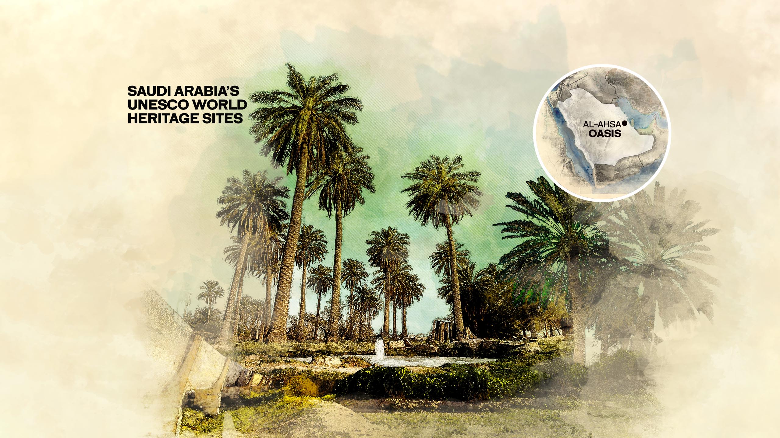
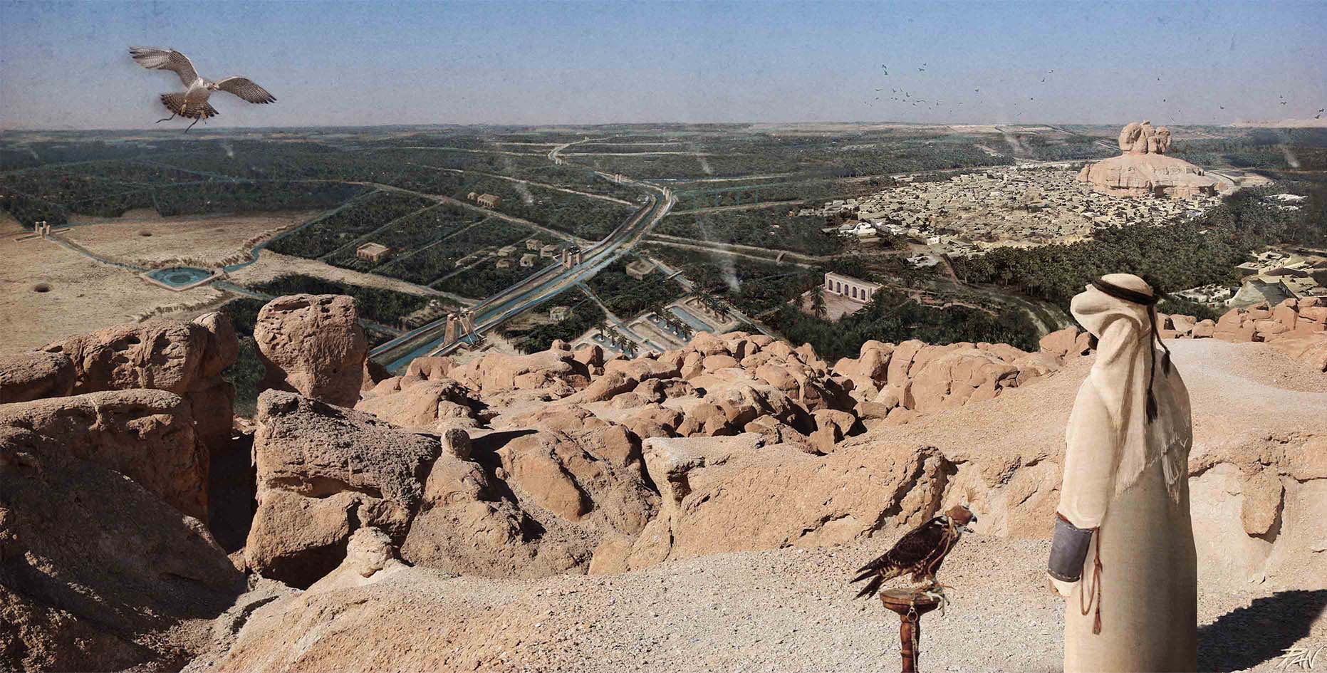
Al-Ahsa: Oasis
An earthly paradise

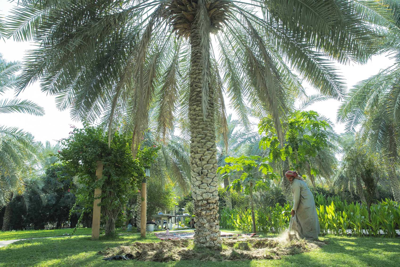
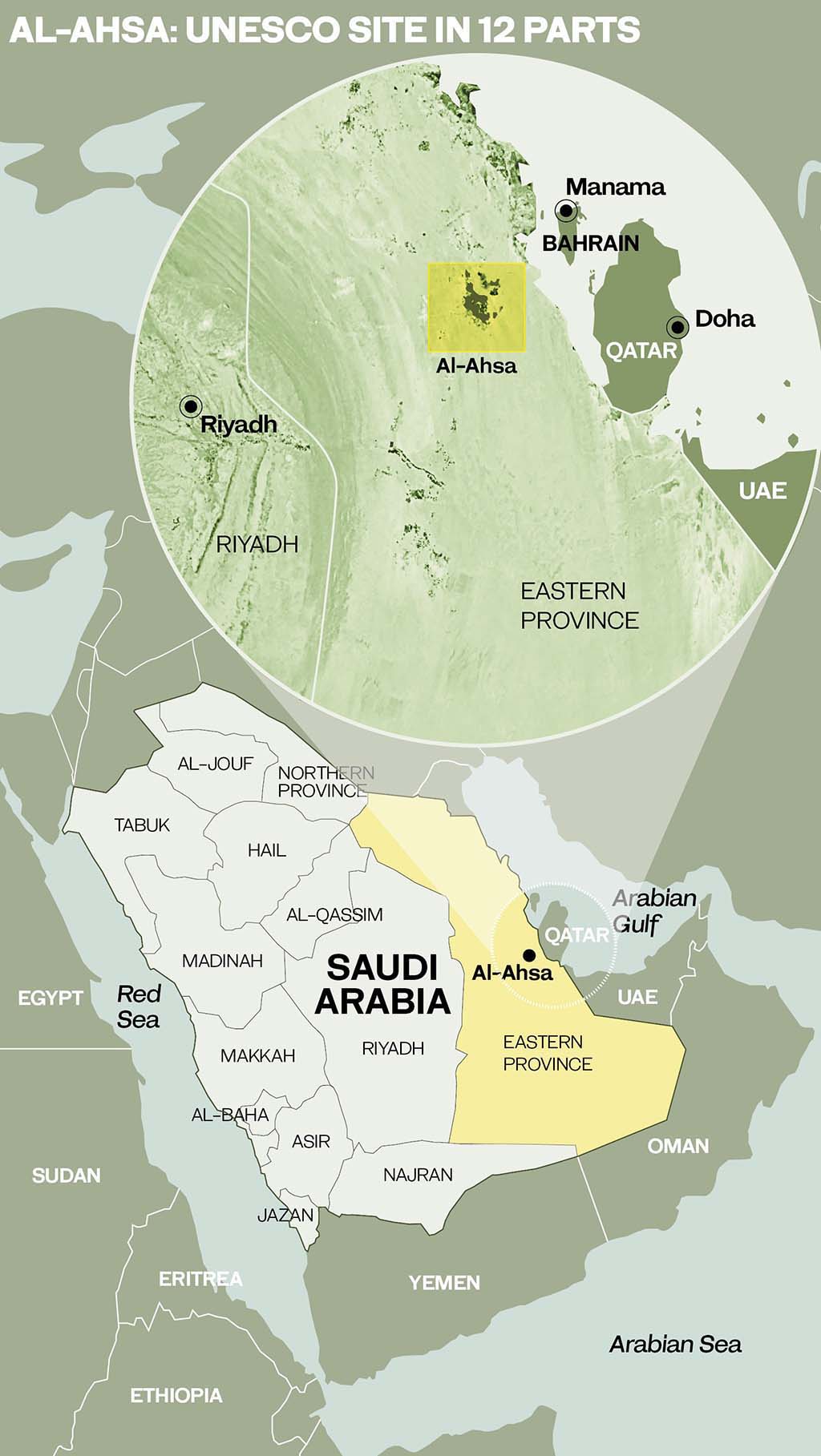
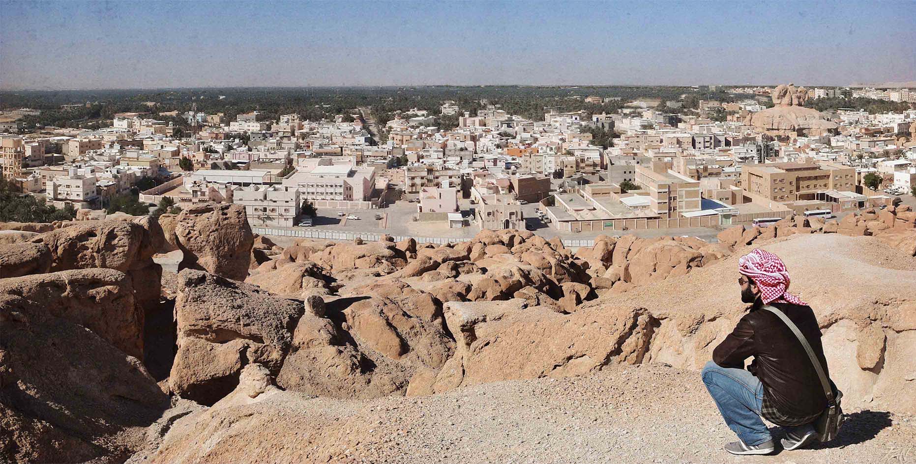
The challenge for the casual visitor to Al-Ahsa is, quite literally, to see the forest for the trees. There are, after all, more than 2.5 million palm trees in the world’s largest and almost certainly oldest oasis. And, with the UNESCO World Heritage site composed of no fewer than 12 separate elements, scattered over a total area of 85-square-kilometers, at first glance this “serial cultural landscape,” which “preserves material traces representative of all the stages of the oasis history, since its origins in the Neolithic to the present,” defies quick and easy appreciation.
For Panaiotis Kruklidis, an Italian architect specializing in cultural heritage who, in 2015 and 2016, was part of the team of experts drafted in to prepare the nomination document that saw the site listed in 2018, the key was to seek a higher perspective.
“We certainly understood the details of the oasis, the organization of its individual plots, but we still couldn’t grasp its overall magnificent size,” he recalled.
“We only discovered it on the day when we decided to climb Jabal Al-Qarah, the hill in the center of the oasis that was probably sacred to the first inhabitants of the place, who had settled among its caves.”
From this vantage point, “it was finally possible to admire the greatness of the oasis as a whole.”

With maps and notebooks in hand and gazing down on the vast geometry of palm groves, gardens and waterways, the team was “able to follow the intricate water system, the lifeblood for every element of the oasis, made up of springs, channels of clean water and drainage.” For Kruklidis, the patterns evoked “the natural geometry of leaves, made up of main and secondary veins.”
Then, Kruklidis and his colleagues set about exploring the oasis at ground level and quickly discovered the beauty of a place in which some scholars believe the date palm was first farmed by human beings.
Al-Ahsa is associated with the Dilmun civilization that flourished in the third millennium BCE in what is now eastern Saudi Arabia. It has also been identified by some archaeologists as the possible site of the near-mythical Sumerian paradise — the garden of the gods where, some 4,800 years ago, the legendary hero King Gilgamesh of Uruk sought the tree of life. The archaeological remains of Uruk, another World Heritage Site, are situated east of the Euphrates River in what is today southern Iraq, some 750 kilometers northwest of Al-Ahsa.
“We decided to ‘get lost’ in the great oasis and entered a private garden, which stood out for the considerable height of its palm trees,” recalled Kruklidis. The first thing they noticed was “the care with which a passionate farmer had maintained his garden. The ancient knowledge of traditional methods, handed down from generation to generation, reflected the charm of myth and time.”
Evening was approaching and the low light that filtered through the palms, casting long shadows and dancing on the surface of the water, began to throw details into sharp relief. Kruklidis, part of whose role was to document key elements of the oasis with drawings, was struck by “the variety of colors of the fruit on the trees, the background of a fragile and fragrant green and the light playing on the water, recalling the labyrinthine waterways and fountains of a distant and almost mythical period.
“It was like seeing the garden of the gods, still standing in Dilmun’s time.”
Kruklidis had no difficulty believing that “it was probably from here that the idea, the image, of the terrestrial paradise, as we know it, developed.”
Heritage conservation expert Simone Ricca, who worked on the nomination documents for four of Saudi Arabia’s UNESCO sites, including Al-Ahsa, said the oasis is “the most complex site to conceptually understand and to grasp.”
Listed by UNESCO as “an evolving cultural landscape,” it is “the product of the interaction between man and nature. Oases are not a natural feature, they are manmade, so they are a perfect example of this concept of a cultural landscape.”
Occupied for at least 8,000 years, Al-Ahsa has seen and survived the rise and fall of great powers over the ages, enduring and outliving all comers, including the Chaldeans, the Achaemenids, Alexander the Great and the Roman and Ottoman empires.
Importantly, and unlike many UNESCO sites that are little more than fragmentary ruins frozen in time, Al-Ahsa has been continuously occupied and continues to thrive and evolve.
“Even the new drainage and water-management systems that have been created since the 1980s are part of this evolving concept,” said Ricca.
“What is amazing is that we still have two and a half million palm trees there, and we also have almost 2 million people living in Al-Ahsa.
“This interaction is intellectually challenging and interesting. For the tourist, it might not be visually so obvious to grasp, but it is central to this concept of the evolving cultural landscape.”
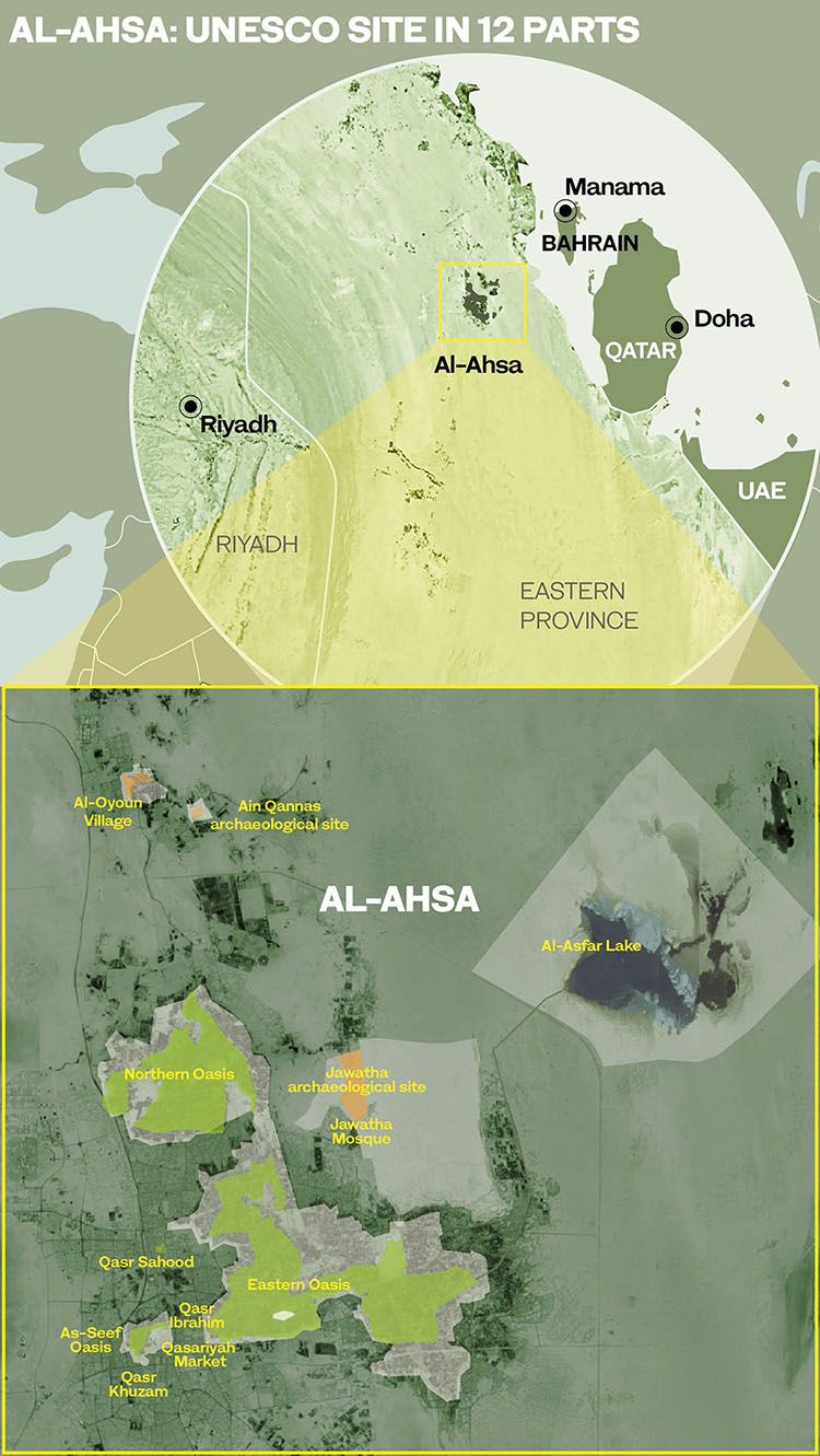
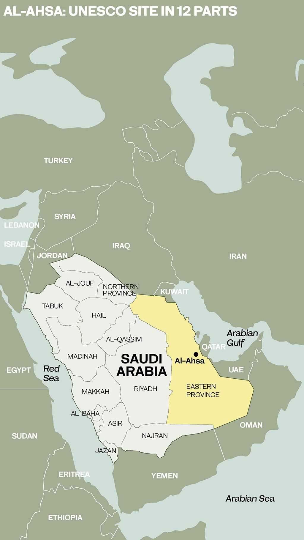
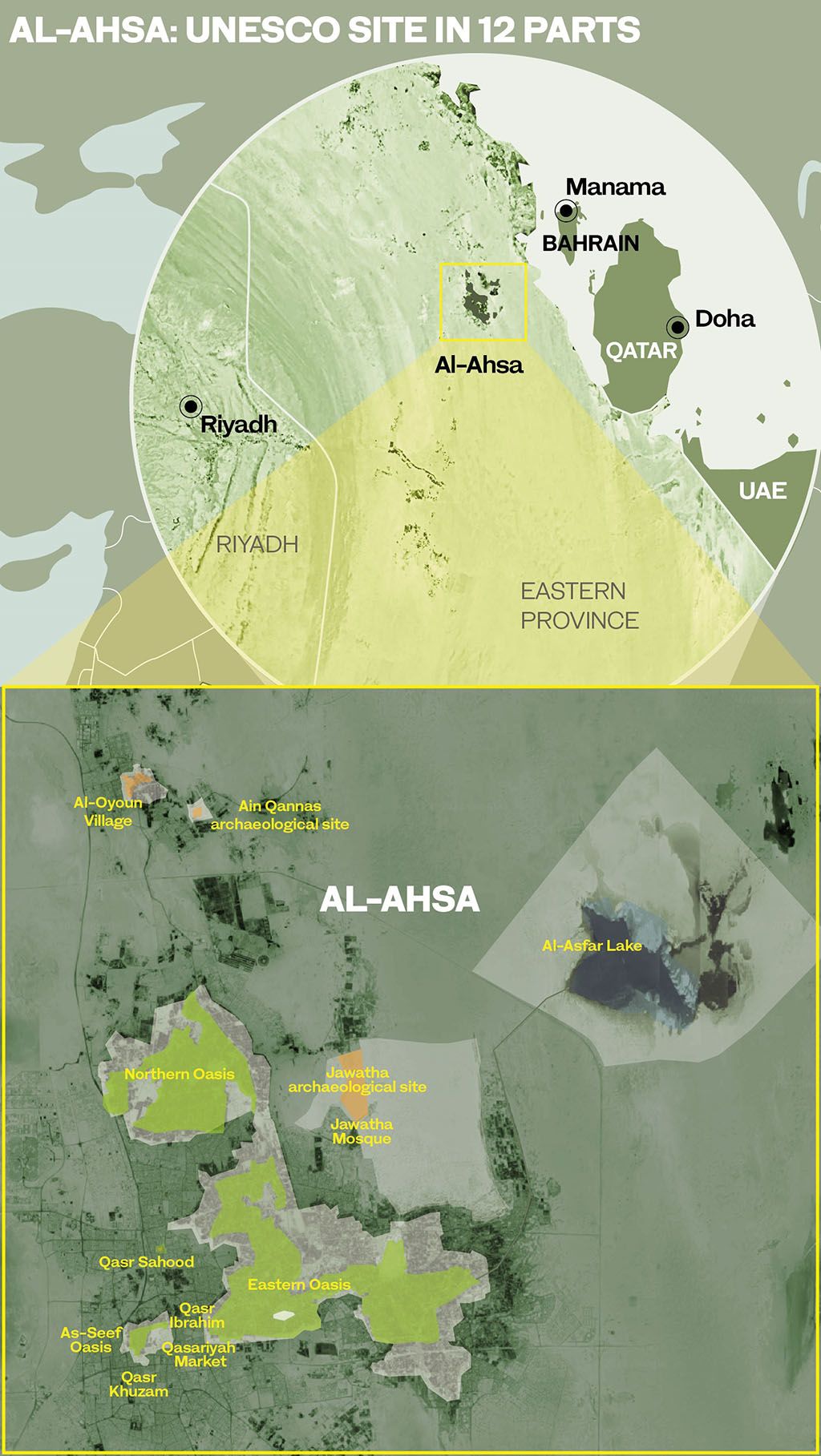
The UNESCO property includes three oases fed by a system of dozens of ancient springs and wells, three castles, the traditional palm-grove village of Al-Oyoun, the historic Qasariyah Market, the Jawatha Mosque, two protected archaeological sites and the 21-square-kilometer mangrove-fringed Al-Asfar Lake, a large and historic body of water into which the waters from the Eastern Oasis drain via an 18-kilometer canal. Al-Asfar has become a unique natural ecosystem and in 2019 was declared a national nature reserve by Saudi Arabia.
The largest of the 12 components is the Eastern Oasis, a roughly crescent-shaped concentration of dense palm groves and gardens over 38-square-kilometers, extending 9 kilometers from north to south and 12 kilometers east to west and watered by an intricate network of canals. At its center is the rocky outcrop known as Jabal Al-Qarah, the summit of which affords stunning views of the surrounding sea of green. To the northwest is the 20-square-kilometer Northern Oasis, which shelters a number of historic villages.
Al-Ahsa lies between the rock desert of Al-Ghawar to the west and the sand dunes of the Al-Jafurah desert to the east. It owed its settlement in antiquity and its continued existence today to the plentiful water provided by the springs of Al-Ghawar, a region that in modern times has provided Saudi Arabia with another natural bounty. Just as Al-Ahsa is the largest oasis in the world, so Al-Ghawar is the world’s largest oil field.
For centuries, the oasis of Al-Ahsa has been under threat from the shifting sands of the Al-Jafurah desert, pressing in from the north, east and south. According to the UNESCO nomination document, “the sands surrounding the oasis, due to the periodically strong north, north-west and southern winds, are mobile and have been encroaching upon the cultivated land and endangering the oasis for many centuries.”
For the past thousand years, humans have had to fight to preserve the oasis, part of which nevertheless “has been covered by an active sand dune field advancing southward, along a 12 km large front.” This dune has “notably covered earlier settlements and gardens north of Al-Qarah, in the area of Jawatha, an important historic settlement of Al-Ahsa Oasis at the dawn of Islam.”
Witness is borne to the historic threat poised to humankind’s dogged but always tentative foothold on existence in the desert oasis by excavations at the Jawatha archaeological site to the north of the Eastern Oasis.
Today, the site is covered entirely with sand, beneath which evidence has been found of ancient agricultural activity, irrigation techniques, long-lost settlements and the course of a vanished river.
Pottery finds from the Ubaid period, dating back roughly 7,000 years, also suggest the Al-Ahsa region may have been among the first in eastern Arabia to have been settled by humans.
Other pottery remains discovered at the site, from Dilmun shards dating from about 2,700 years ago and Greek and Roman ceramics to early Islamic pottery, testify to Al-Ahsa’s long and profitable existence as a major trading center.
Even in antiquity, as the UNESCO nomination document notes, Al-Ahsa was known as “the most famous and largest oasis in the world,” celebrated by Greek, Roman and medieval Arab scholars and travelers.
According to “Geographica,” an account of the then-known world by the Greek historian Strabo, published in 7 BCE, ancient Al-Ahsa was connected to Mesopotamia — modern-day Iraq — by trade in spices, aromatics and dates. The inhabitants, he wrote, carried their cargoes “on rafts to Babylonia, and thence sail up the Euphrates with them, and then convey them by land to all parts of the country.”
Alive and well today, thanks to large-scale anti-desertification initiatives and the re-organization of water distribution techniques, including the creation of a new network of canals since the late 1960s, Al-Ahsa is living history.
In the words of the nomination document that won Al-Ahsa recognition as a UNESCO World Heritage Site, the ongoing story of the evolution of the oasis, the origins of which coincide with the very beginnings of agriculture, “explains how very ancient human communities were born and worked, and it enables us to understand the techniques, procedures and principles permitting the establishment of harmonious and balanced relationships between human presence and land management.”
Al-Ahsa continues to supply dates to a global market. But perhaps its most valuable export is the example set for both the present and the future by its thousands of years of stubborn and ingenious existence in the face of great environmental odds.
Today, in the words of the UNESCO citation, “all over the planet entire ecosystems are at risk of collapse. Oases can show us how to better handle the interaction with the environment by improving its resources without depleting them. Climate change, the collapse of ecosystems, cataclysms, the end of civilization, are conditions that the people of the desert have already faced many times.”
Al-Ahsa, it says, “is an extraordinary example of evolution through time of an oasis landscape,” and one that has invaluable lessons for life on earth — and beyond.
The techniques honed over centuries, “for the creation of fertile soils — for agricultural production, water management, recycling, energy saving, survival in the desert — constitute an example of good practices for the entire planet, providing knowledge applicable to the new frontiers of human diffusion to extreme environment — including extraterrestrial ones.”

An aerial view of part of the oasis taken in 1965. (Saudi Aramco)
An aerial view of part of the oasis taken in 1965. (Saudi Aramco)

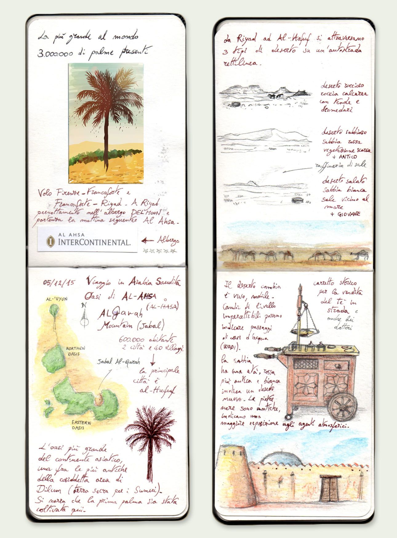
Sketches from the notebook of Panaiotis Kruklidis, an Italian architect who helped to prepare the document nominating Al-Ahsa as a UNESCO World Heritage Site.
Sketches from the notebook of Panaiotis Kruklidis, an Italian architect who helped to prepare the document nominating Al-Ahsa as a UNESCO World Heritage Site.

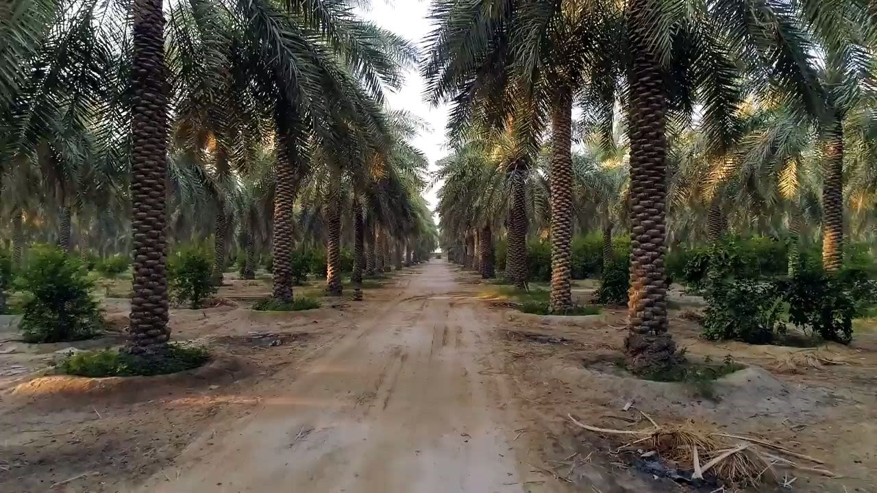
The palm groves at Al-Ahsa are, according to the UNESCO nomination document, “among the largest at the global scale.” They also preserve the historical characterstics of systems based on “traditional techniques remained unchanged...for thousands of years.” (Saudi Ministry of Tourism)
The palm groves at Al-Ahsa are, according to the UNESCO nomination document, “among the largest at the global scale.” They also preserve the historical characterstics of systems based on “traditional techniques remained unchanged...for thousands of years.” (Saudi Ministry of Tourism)

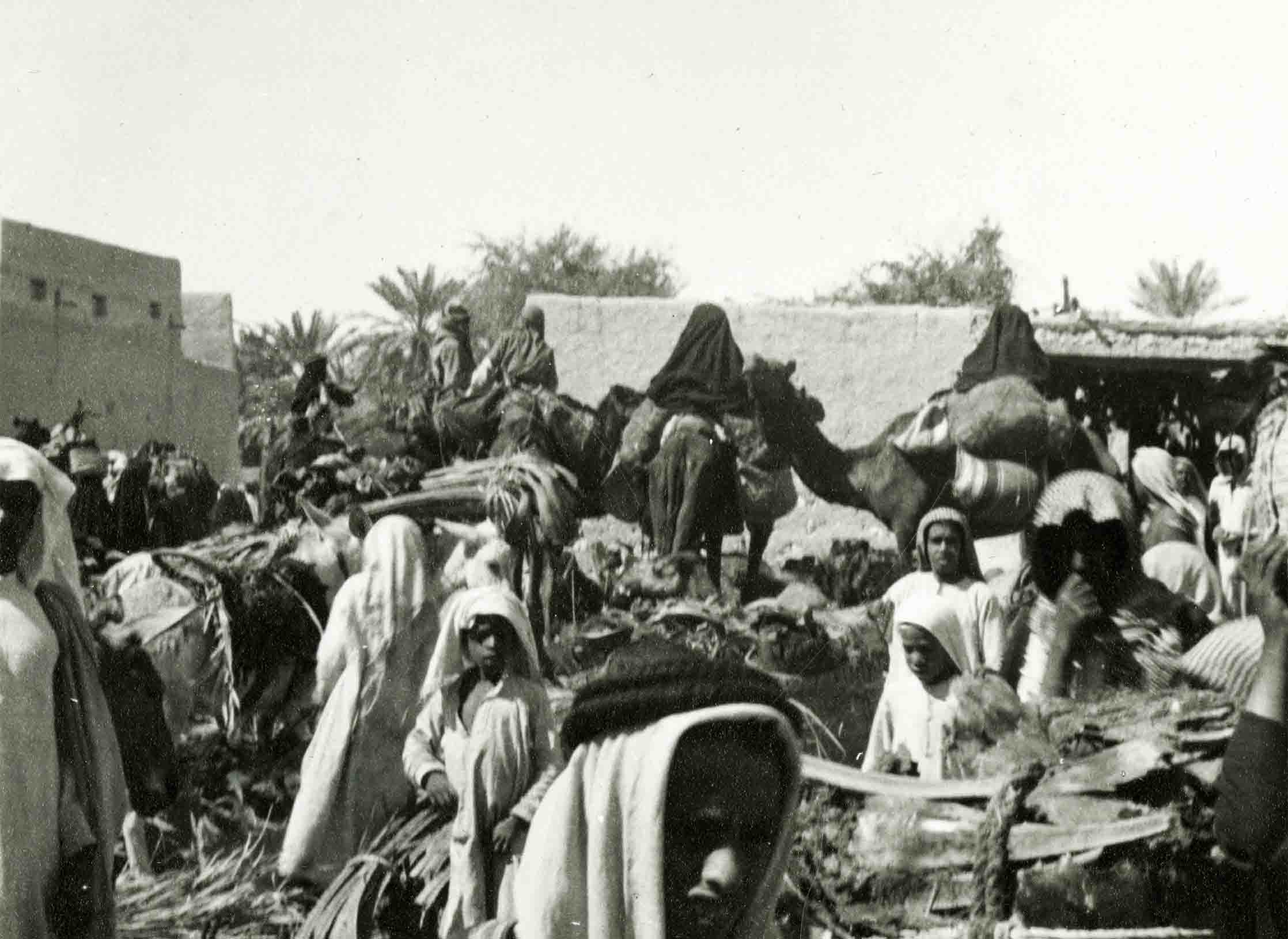
A bustling marketplace at Al-Ahsa Oasis, captured in this 1937 photograph by Geraldine Rendel, the wife of a British diplomat and the first European woman to be received in public by Ibn Saud, the founder of Saudi Arabia. (Middle East Center Archive, St Antony’s College, Oxford)
A bustling marketplace at Al-Ahsa Oasis, captured in this 1937 photograph by Geraldine Rendel, the wife of a British diplomat and the first European woman to be received in public by Ibn Saud, the founder of Saudi Arabia. (Middle East Center Archive, St Antony’s College, Oxford)

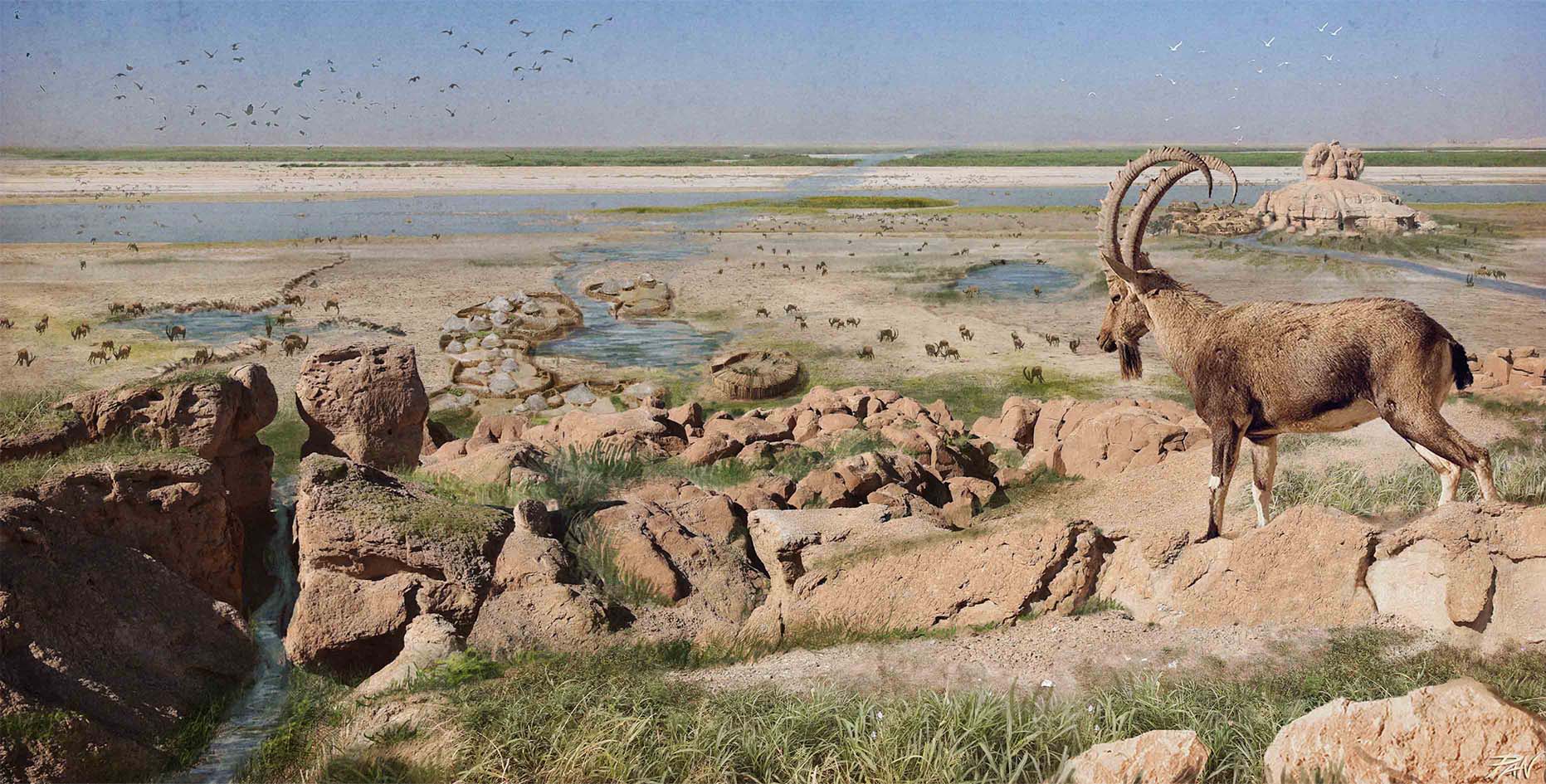

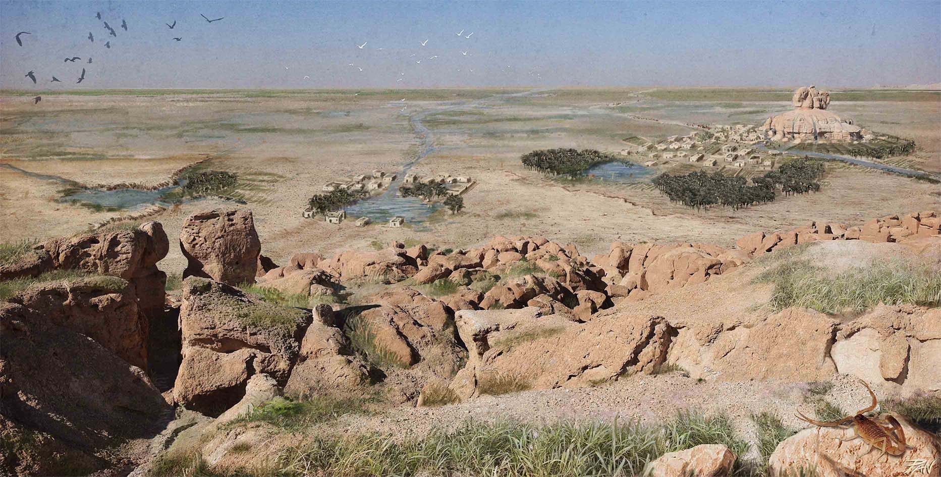


A series of renderings by the Italian architect and heritage expert Panaiotis Kruklidis shows the transformation of the Arabian landscape and the oasis of Al-Ahsa from the Neolithic age, over 4,000 years ago, to the Bronze Age ...
... through the Hellenistic Age ...
... and the Middle Ages ...
... to modern times.
Uruq Bani Ma’arid
Where the wild things live


Uruq Bani Ma’arid, adopted by UNESCO in 2023, is the first natural site in Saudi Arabia to be inscribed on the organization’s World Heritage List. Covering a vast area, it occupies the western part of the Rub’ Al-Khali, or Empty Quarter, the greatest continuous expanse of wind-blown sand on Earth and one of the world’s most spectacular desert landscapes.
This is the last place where free-ranging Arabian Oryx were seen before the species was officially declared extinct in the wild more than 40 years ago.
The last animals — one pair in 1978 and a solitary oryx in 1979 — were spotted from the air, by helicopter pilots working for the Ministry of Petroleum and Mineral Resources.


A group of newly released Oryx explore their new home in Uruq Bani Ma'arid. (Muhammad Al Yousifi)
A group of newly released Oryx explore their new home in Uruq Bani Ma'arid. (Muhammad Al Yousifi)
Until the early 1800s, the Arabian oryx (Al-Maha, or Al-Wudehi in Arabic) was widespread, not only in most of the Arabian Peninsula, but also in Sinai, Palestine, Transjordan and much of Iraq.
Throughout the 19th and 20th centuries, owing to hunting and loss of habitat to human expansion, its range gradually shrank, until by 1914 there were few reports of the animal being found outside the area that in 1932 would become the Kingdom of Saudi Arabia.
By the mid-1930s, the only known remaining populations were in Saudi Arabia’s northwestern Nafud desert and in the southerly Empty Quarter and parts of Oman.
As the UNESCO nomination document for Uruq Bani Ma’arid records, the balance finally tipped irrevocably against the oryx with the search for oil during the 1930s, when “game hunters and oil company employees started hunting Arabian Oryx with automobiles and rifles.”


Early morning light illuminates a group of Arabian Oryx and a landscape of spectacular sand dunes. (Othman Llewellyn)
Early morning light illuminates a group of Arabian Oryx and a landscape of spectacular sand dunes. (Othman Llewellyn)
Hunting quickly got out of control, to the extent that, incredibly, “some hunting excursions were reported to deploy as many as 300 vehicles.”
As a result, by the 1950s the northern population of oryx in Saudi Arabia was in effect extinct, and “the last specimens in the wild were reported in … Uruq Bani Ma’arid in 1979.”
In 1986, when the government became aware of just how badly the country’s most iconic wildlife was being depleted, it formed The National Commission for Wildlife Conservation.
That year also saw the designation of the first protected area in the country – Harrat al-Harrah, an area of 13,775-square-kilometers in the north of the country, home to animals including Reem gazelle, Arabian wolf, red fox, sand fox and striped hyena.
Other protected areas followed – by 2021 there were 14 across the country, including Uruq Bani Ma’arid, designated in 1992. Together, these areas cover a total of almost 83,000-square-kilometers – about 5 percent of the Kingdom’s total land.


The debris of rocks deposited by millions of years of tectonic upheaval at the edge of the Tuwayq escarpment. (Tarek Abulhawa)
The debris of rocks deposited by millions of years of tectonic upheaval at the edge of the Tuwayq escarpment. (Tarek Abulhawa)
Under the Saudi Green Initiative, which was launched in 2021, plans are in place to increase the total size of protected areas to 645,000-square-kilometers – 30 percent of the Kingdom’s territory and an area larger than France.
In 1989 the wildlife commission embarked on a captive breeding program for the Arabian Oryx and since 1995 Uruq Bani Ma’arid has been the scene of a successful reintroduction program for the animals, initially bred in captivity at the National Wildlife Research Center in Taif.
Other important mammals, including the largest population of Arabian Sand Gazelle and the second-largest concentration of Arabian Mountain Gazelle, have also been introduced into the territory.
Today, the population of oryx, which are found throughout the entire reserve and whose numbers vary seasonally, according to natural conditions, ranges between 125 and 150 animals.
During the summer months, the Mountain Gazelles live mainly among the stands of Acacia trees of the plateau, wadis and inter-dune corridors of the western part of the property, which abuts the eastern edge of the Tuwayq escarpment.
However, they disperse in the winter and can range far into the sands of the Empty Quarter, beyond the territory’s eastern boundary.
Their numbers also naturally vary according to the season, from about 150 to 300 animals.
Similar to the oryx, Arabian Sand Gazelles are also found throughout Uruq Bani Ma’arid.
The area was once part of the natural habitat for these species, the populations of which have been re-established in programs first begun in 1995.
Long before its adoption by UNESCO, the 12,756-square-kilometer Uruq Bani Ma’aridit was designated in 1992 by the Saudi government as one of the largest protected areas in the Kingdom.
As the UNESCO nomination document notes, “more than any other site, this hyper-arid desert represents the iconic wilderness of Arabia” and “conserves one of the Earth’s most spectacular desert landscapes with a wide variety of wildlife habitats.”
Its border marked at intervals around the perimeter by concrete pillars, posted within view of each other, the site is patrolled and managed by a team of more than 140 rangers. It is also protected by virtue of its remoteness, and the lack of nearby roads or human development, which has been naturally deterred by the rugged terrain and the harsh climate of the area.
The entire site, which is owned by the state, is protected from oil and gas exploration by royal decree and camel grazing and wildlife hunting is banned, creating a natural environment in which myriad species of plants and animals thrive on their own terms.
The “stars” of the show are the large mammals – the protected area is home to the only free-ranging population of the iconic Arabian Oryx in the world – but Uruq Bani Ma’arid is home to countless other species.


Captured during a rare climatic moment in 2017, hailstones lay briefly on the sand dunes of Uruq Bani Ma’arid. (Hamad Al Qahtani)
Captured during a rare climatic moment in 2017, hailstones lay briefly on the sand dunes of Uruq Bani Ma’arid. (Hamad Al Qahtani)
Here can be found 118 species of plants – many of global importance – and 23 mammal, 104 bird, 18 reptile and 382 invertebrate species.
Among the mammals, the Arabian Wild Cat, Arabian Sand Cat, Honey Badger, Arabian Hare and Pygmy Gerbil are of regional significance, facing the loss of their natural habitats in other parts of the Peninsula.
The Arabian Wolf has been spotted in the rocky western part of the territory in wintertime.
Among the birds found here, either permanently resident or seasonal visitors, are the Lappet-Faced Vulture, Egyptian Vulture, Houbara Bustard and Pallid Harrier, all of global conservation significance.
The reptiles of Uruq Bani Ma’arid were studied systematically in 2021. The survey found three types of snakes – the Arabian horned viper, the Braid snake and the Arabian sand boa – several species of geckos and lizards and the Desert monitor.
Aside from the many plants and animals that thrive there, in the words of the UNESCO document Uruq Bani Ma’arid represents “the intersection of two outstanding features of the Arabian Peninsula: the sand desert of the Rub al-Khali and the limestone escarpment of Jabal Tuwayq.”
Roughly the size of Ukraine, the Rub al-Khali – Empty Quarter, in English – is not only the most iconic sand desert of the Arabian Peninsula, but “arguably, along with the Sahara, the most iconic desert on Earth.”


The stunning landscape of the western Empty Quarter at Uruq Bani Ma’arid. (Hamad Al Qahtani)
The stunning landscape of the western Empty Quarter at Uruq Bani Ma’arid. (Hamad Al Qahtani)
For generations, the sands were the province of the Bedu, who lived on its edges and ventured into it to hunt and to graze their camels.
The fame of the landscape spread farther afield thanks to the handful of European explorers who were drawn to the challenge it posed to travellers and wrote of its beauty.
The British explorer Wilfred Thesiger, who crossed the Empty Quarter for the first time in 1946-47 and fell under the spell of Uruq Bani Ma’arid, wrote eloquently of the patterns and colors that make each group of dunes in the desert unique, acting almost as signposts for the seasoned Bedu traveller.
Thesiger and his Arabian companions crossed the Empty Quarter for a second time in 1947-48, their journey ending in Uruq Bani Ma’arid.
“We reached the Aradh at one o’clock and camped two hours later in a shallow watercourse on the limestone plateau,” he wrote in his book “Arabian Sands.”
He bade the desert he had come to love a poetic farewell.
“The valleys when I woke at dawn were filled with eddying mist, above which the silhouettes of the dunes ran eastwards, like fantastic mountains towards the rising sun.
“The sky glowed softly with the colors of the opal. The world was very still, held in a fragile bowl of silence.
“Standing at last on the far threshold of the Sands I looked back, almost regretfully, the way we had come.”


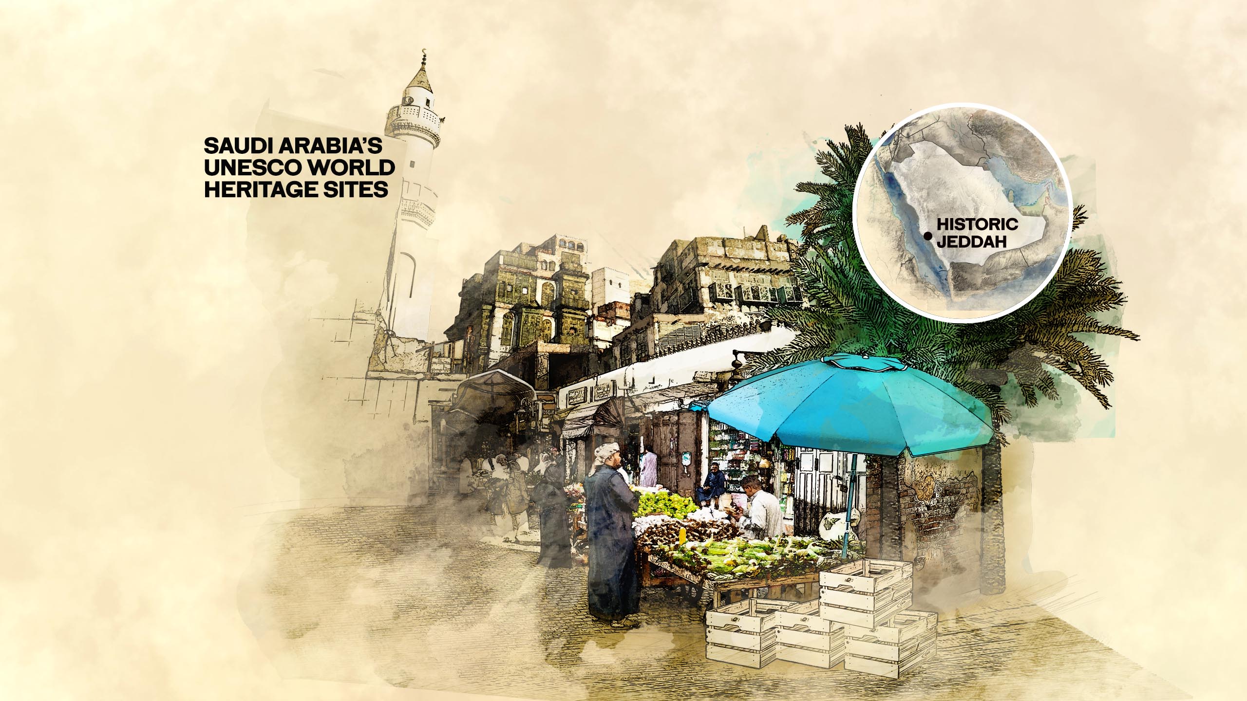
Historic Jeddah:
Gateway to Makkah
The old beating heart of a modern city

In April 2020, London rare-books dealer Peter Harrington offered for sale a collection of engineering plans that told the story of the modernization of Jeddah’s water supply, a long-overdue upgrade to a creaking Ottoman system ordered in 1947 by Ibn Saud to improve the quality of life for pilgrims arriving in the city.
Among the papers was a map made by the British engineering company Balfour & Sons, which had been contracted to carry out the work. The map had been drawn up for the everyday purpose of recording the routes of the newly laid water mains.
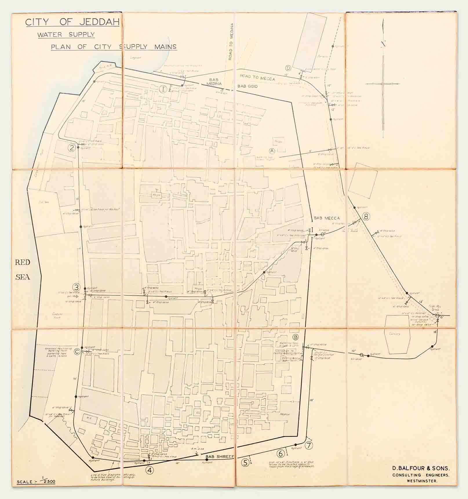
But today, as the last known illustration of the layout of the old city of Jeddah, complete with the great defensive wall that once encircled it, the map has acquired the status of a rare and historically priceless artifact.
Within months of the completion of the drawing, work had begun on the demolition of the old wall, parts of which dated back to the 16th century, and the four gates that had controlled access to the city through hundreds of years of turbulent history.
By 1947, in addition to benefiting from an increase in the number of pilgrims following the end of the Second World War, Saudi Arabia was in the grip of its first great oil boom. Jeddah, since 647 the gateway port to Makkah and always an important town for seaborne trade on the Red Sea, was thriving and expanding rapidly.
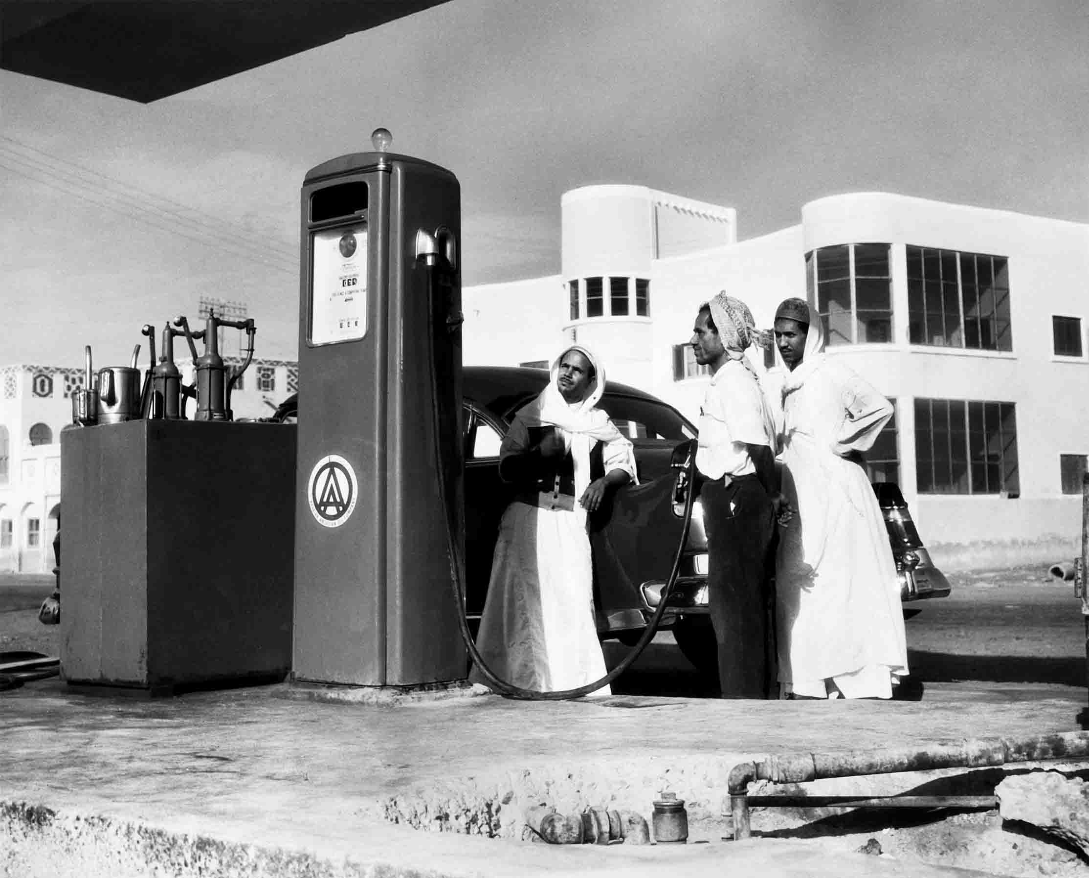
“Until 1947, Jeddah was still surrounded by its wall, and it was a really small place, less than one-square-kilometer, with a few suburbs in the south,” said architect Simone Ricca, a heritage conservation expert who helped to prepare Saudi Arabia’s successful application to have the city listed as a UNESCO World Heritage Site.
“It was a seasonal city, living through the arrival of pilgrims, many of whom would stay a few months in the city. Because of that, houses were built with floors that were rented out to pilgrims, and this helped create the special architecture we see today in the old town.”
By 1956, with the flow of oil money funding modernization and expansion programs across the country, Jeddah had burst its bounds and, in under 10 years, had swollen to ten times its size a decade earlier.
By the end of the 1970s, Jeddah Islamic Port had been built on reclaimed land, cutting off the old town from the sea, and the population of the city had risen to close to 1 million.
But despite Jeddah’s rapid expansion, thanks to the dedication of many individuals and organizations determined to conserve the historic heart of the city known fondly to Jeddawis as Al-Balad, the old town somehow managed to survive. In 2014, it became the third historic site in Saudi Arabia to be inscribed on the UNESCO World Heritage List as being of “outstanding universal value.”
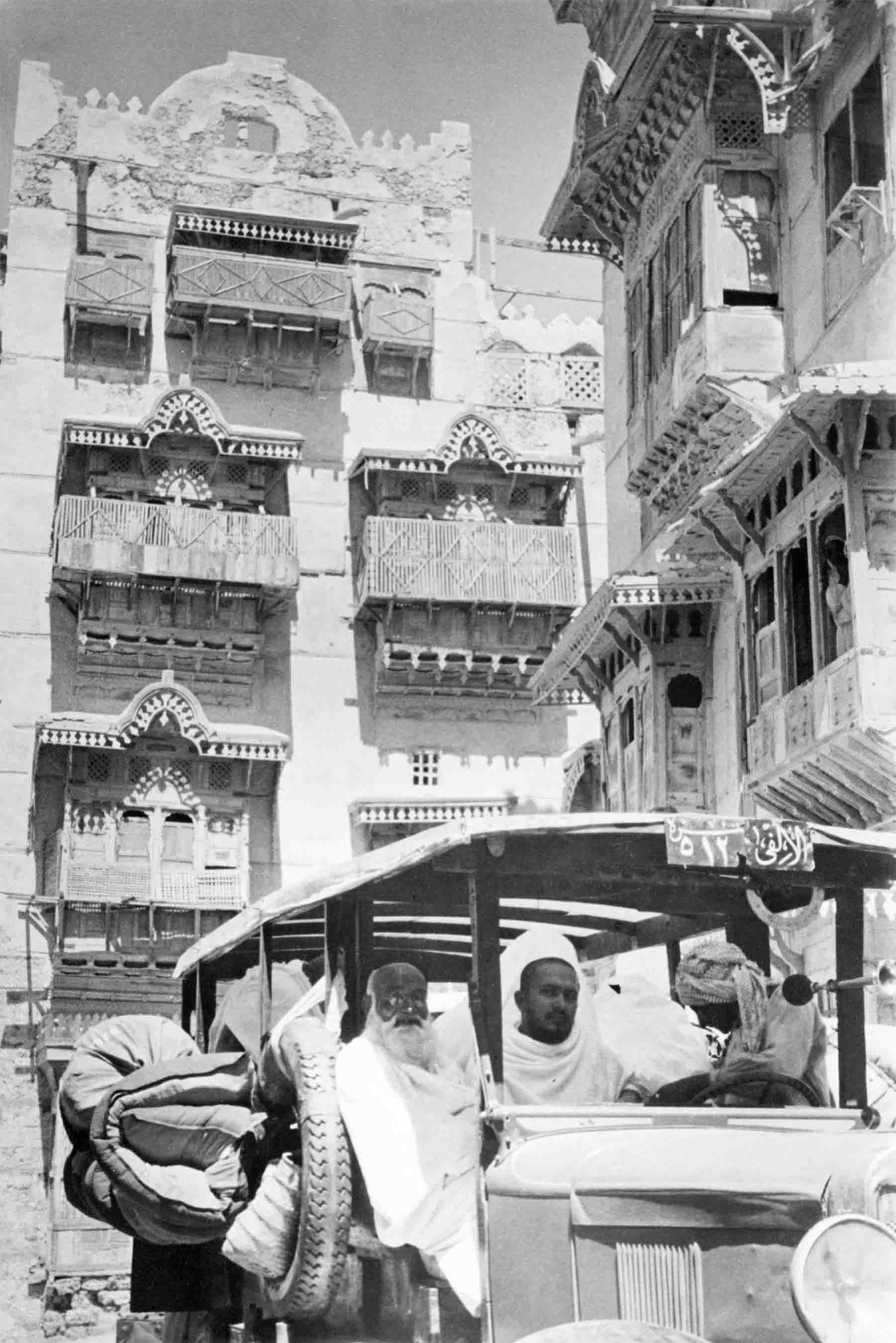
Jeddah has been linked inextricably with the Hajj ever since 647, when Uthman ibn Affan, a companion of the Prophet and the third Rashidun caliph, designated it as the gateway port for pilgrims traveling to the holy cities of Makkah and Madinah.
For hundreds of years, pilgrims bound for Makkah arrived in ships that anchored off Jeddah’s shallow harbor, putting ashore in small wooden dhows, or sambouks, to seek lodgings, food and supplies in the houses and souqs lining its narrow, bustling streets. When the time came, they set off on foot or on camel to travel the 70 kilometers to the holy city.
The original Bab Makkah, the eastern gate through which generations of Muslims passed at the start of their spiritual journey of a lifetime, is no more. But as though still protected by the long-vanished walls behind which they once stood, the streets, souqs and buildings of the old town preserve the memory of a vanished way of life even as they echo with the vibrancy of the modern city that surrounds them.
Urban archaeologists believe that the layout of the old town, and perhaps even the architectural style of Jeddah’s buildings, probably dates to at least the 16th century, but Jeddah’s origins can be traced back much further. Archaeological finds in the area, including ancient inscriptions in wadis east of Jeddah, suggest it may have been occupied since the late Stone Age, more than 3,000 years ago.
Thanks to its roles as both a major trading center and as the gateway to Makkah, Jeddah became a melting pot, influenced by the customs, food, skills and products brought by traders and pilgrims from across Africa and Asia, many of whom chose to settle in the town.
In the words of the UNESCO nomination document, the result was “a unique cultural ensemble,” and the surviving cityscape of Historic Jeddah is the product of “an important exchange of human values, technical know-how, building materials and techniques across the Red Sea region and along the Indian Ocean routes between the 16th and the early 20th centuries.”
As such, it represents “a cultural world that thrived thanks to international sea trade, possessed a shared geographical, cultural and religious background, and built settlements with specific and innovative technical and aesthetic solutions to cope with the extreme climatic conditions of the region.”
Always the most important, largest and richest of the Red Sea settlements, today Jeddah’s old town is the last surviving example of an otherwise vanished social and architectural urban style, “an extraordinary pre-modern urban environment where isolated tower houses, lower coral stone houses, mosques, ribats, souks and small public squares compose a vibrant space, inhabited by a multicultural population, that still plays a major symbolic and economic role in the life of the modern metropolis.”
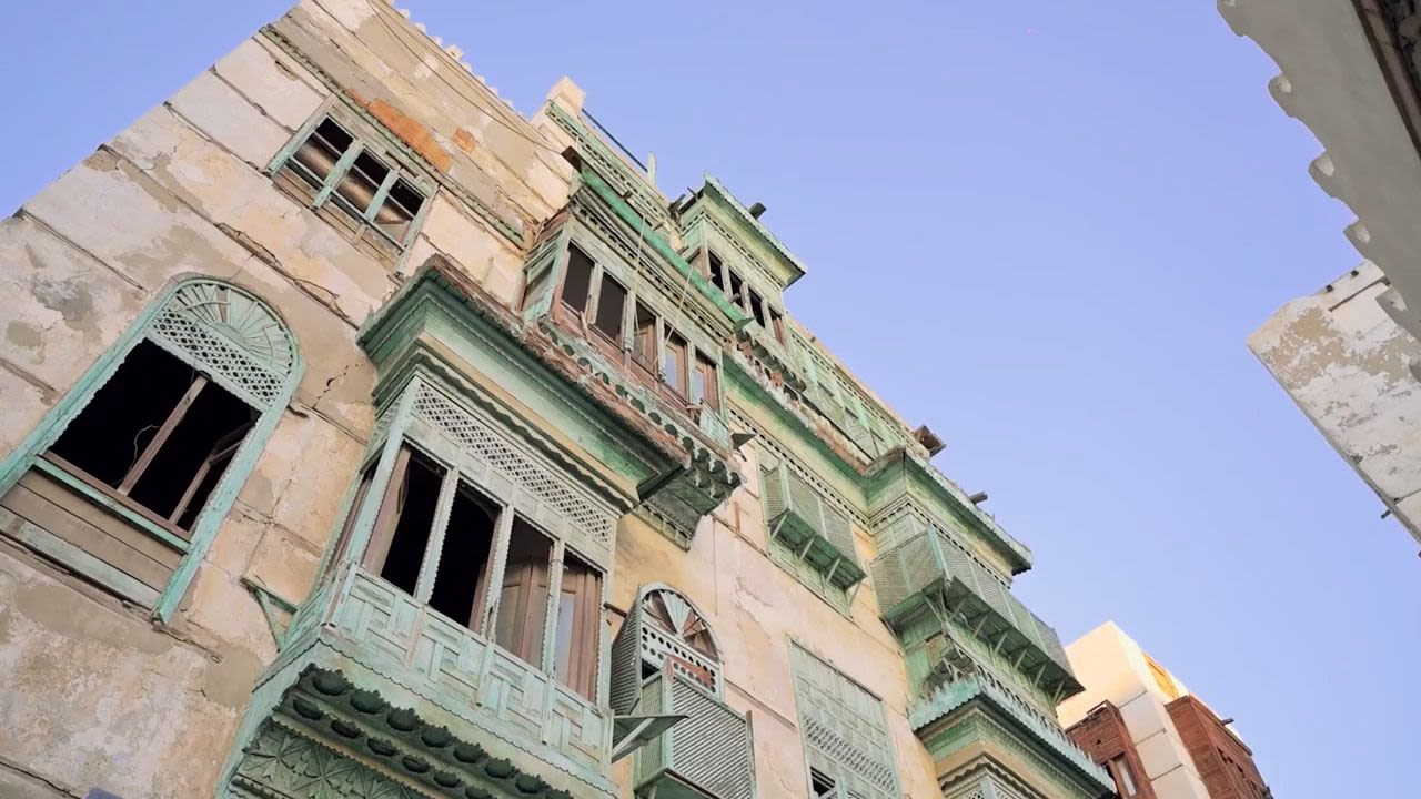
The most distinctive manifestations of that style are the roshan tower houses, some 300 of which survive. A product of economic and environmental circumstances, this style of architecture began to emerge during the second half of the 19th century as a direct by-product of the opening of the Suez Canal in 1869, which boosted Jeddah’s role as an important port linking East and West.
As Jeddah’s merchants grew more and more prosperous, they built higher and more elaborately decorated houses reflecting their new position and wealth. Some houses reached as high as six or even seven stories. Built tall to capture breezes wafting in from the sea, the stairwell or lightwell at the center of many houses, left open to the sky, was designed as a ventilation shaft that allowed hot air to escape upward, increasing airflow inside the building.
“During the hot summer months, residents of a traditional Jeddawi home would sleep in the mabeet, the sleeping quarters on the top floor of the home, with large windows and slits to allow good ventilation,” said Ahmed Badeeb, a resident of Jeddah and a conservationist who was part of the Saudi team that successfully presented Jeddah’s case at the 38th session of UNESCO’s World Heritage Committee in Qatar in 2014.
Jeddawi Ahmed Badeeb takes us on a tour of Harat Al-Mazloom.
Old Jeddah’s homes, he said, were built from locally available and imported materials and were “designed and engineered in a manner that would ensure longevity and handle the climate.” Coral limestone was taken from the nearby Red Sea reefs and then crushed and mixed with mud or clay from lake beds to create bricks.
The finished buildings were then whitewashed using an insulating substance Jeddawis called al-norah, made from heated limestone mixed with mud, which helped to keep the insides of buildings cool during the blisteringly hot summer months.
The traditional Jeddawi home, Badeeb said, “was constructed around one large main base pillar known as fahl al-daraj, around which the stairs would be built, with rooms off to the sides.
“Each level was designed according to its function. At the entrance of the home, the diwan was where guests were received and was designated specifically for men. The back area of the house was where the women of the household, children and help usually stayed.”
Many homes had a majlis, “an area similar to the diwan but located on the second floor, with wooden seating areas and pillows pushed toward the walls and the large roshan window at the far wall overlooking the outside streets and alleys.”
The rawasheen (plural of roshan), elaborate wooden bay windows that front many of the surviving houses, served several roles, creating a cool and private place for sitting and sleeping and a sanctuary where women could watch the world outside without being seen from the street. The design of the roshan was so effective at creating cross-ventilation that clay water pots were placed in them to be cooled in the shade and the airflow they created.

“It’s difficult to pinpoint where the roshan originated from, as Jeddah was home to many different cultures,” said Badeeb. “The ventilation system would help keep homes cool during the day, and the intricate designs helped to break up the searing heat of the sun’s rays.
“Residents would also be able to peer out through the holes while ensuring their privacy. People outside weren’t able to see whoever was looking out.”
Thanks to imports of timber, mainly hardwoods from Asia and Africa, wood played a vital part in the evolution of Jeddah’s homes, from the development of the roshan to the use of a technique known as takleel, in which wooden beams were used to strengthen brickwork, allowing some houses to be built up to six or seven stories high.
The use of timber is also evident in the large and beautiful doors that grace many of the old buildings. Originally signs of wealth and prestige, they are made from solid wood, often teak, and decorated with elaborately carved panels acknowledged in the UNESCO nomination as examples of “some of the finest carpentry and decoration in Arabia.”
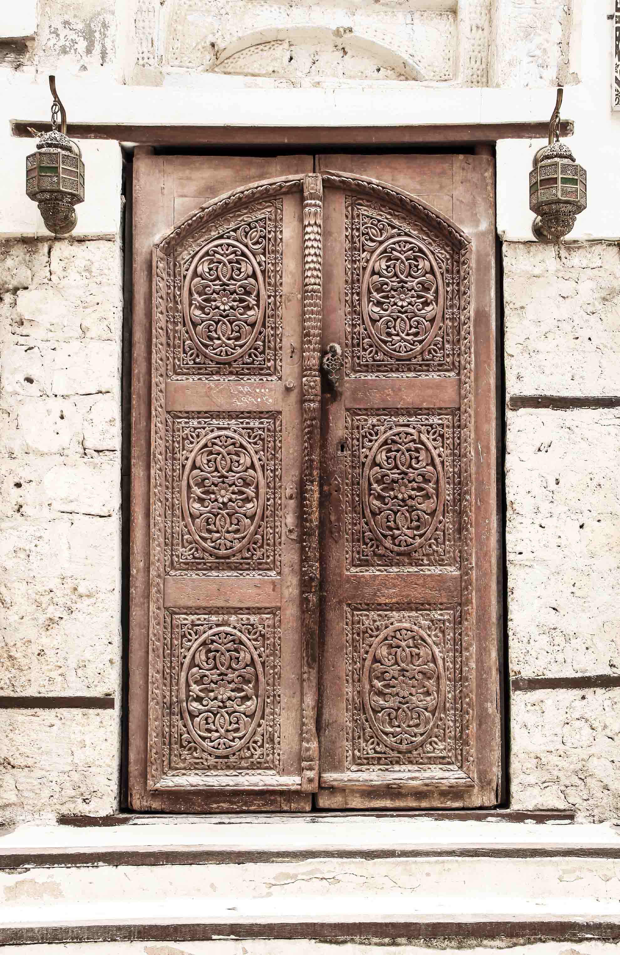
Jeddah’s listing in 2014 as a World Heritage Site has helped to reinforce the conservation efforts over the years of successive mayors of Jeddah and many individuals who, like Badeeb, were born and raised in Al-Balad and were determined not to let it die.
“When the city grew up out of its walls, it was easier and cheaper to build outside on barren land,” said Simone Ricca. “But the historic families of Jeddah were still very much attached to their old buildings, and so although they moved out, they kept the family mansions and the city retained its active soul, as it does to this day.”
Conserving Old Jeddah has not been an easy task, said Badeeb, whose old family home in the Mazloom quarter is still standing. “It took a lot of effort and time by families who inherited their homes from their fathers and grandfathers. The area was lost for a while as the urban development of Jeddah flourished and turned into the sprawling city it is today and, for a long time, houses were neglected and (occupied) by expatriates as Jeddah’s families moved out.”
The UNESCO document notes that “until the early 1950s, extended Saudi families and long-established Yemeni, Indian and East Asia trading families inhabited the old city houses. Following Jeddah’s spectacular growth prompted by increasing pilgrims and oil revenues, the local residents left their traditional abodes to move to newly built suburbs.”
The old city houses, it added, were now “mainly occupied by a high proportion of single, male foreign workers who rent a room, or part of a room, from Saudi landlords.”
Badeeb attributes the saving of old Jeddah in part to conservation initiatives launched by a series of governors of the province of Makkah, started by Prince Majed bin Abdul Aziz and continued by his successors Prince Abdul Majeed bin Abdul Aziz and Prince Khalid Al-Faisal, supported by some of Old Jeddah’s families.
Ricca also highlights “the choices made by the mayor of Jeddah, Dr. Mohammed Said Farsi, who while developing a modern city also decided partially to preserve part of the old city.”
A trained architect who became mayor in 1972, Farsi oversaw a five-fold growth in the city’s population by the mid-1980s and was widely known as the father of modern Jeddah. It was, as an obituary published upon his death in 2019 noted, “remarkable that in the midst of creating much-needed infrastructure, Dr. Farsi found time to create a city that was as beautiful as it was functional, with a carefully preserved historic centre.”

This 1947 map, a technical record of Jeddah’s newly installed water system, shows the layout of the old town shortly before its walls were torn down to make way for the city’s rapid expansion. (Peter Harrington Rare Books, London)
This 1947 map, a technical record of Jeddah’s newly installed water system, shows the layout of the old town shortly before its walls were torn down to make way for the city’s rapid expansion. (Peter Harrington Rare Books, London)

A service station in Jeddah in 1952. By then Saudi Arabia was in the grip of the oil boom that would transform the Red Sea port and the entire country. (Getty Images)
A service station in Jeddah in 1952. By then Saudi Arabia was in the grip of the oil boom that would transform the Red Sea port and the entire country. (Getty Images)

Minarets rise above the city walls of Jeddah in this engraving of the city, published in 1851. (Getty Images)
Minarets rise above the city walls of Jeddah in this engraving of the city, published in 1851. (Getty Images)

Two of the roshan tower houses that are unique to Old Jeddah can be seen in this 1939 photograph. (Getty Images)
Two of the roshan tower houses that are unique to Old Jeddah can be seen in this 1939 photograph. (Getty Images)

Tower houses, with their original elaborate screened bay windows, or rawasheen, are among the most striking features of Jeddah's historic quarter. (Shutterstock)
Tower houses, with their original elaborate screened bay windows, or rawasheen, are among the most striking features of Jeddah's historic quarter. (Shutterstock)

Elaborately carved wooden doors, made from timber imported from Asia and Africa as Jeddah rose to prominence as a major trading hub, decorated the houses of wealthy merchants in the old city. (Shutterstock)
Elaborately carved wooden doors, made from timber imported from Asia and Africa as Jeddah rose to prominence as a major trading hub, decorated the houses of wealthy merchants in the old city. (Shutterstock)


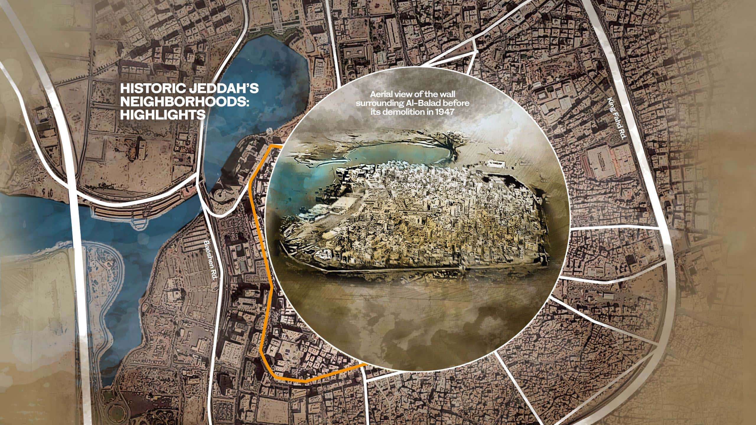

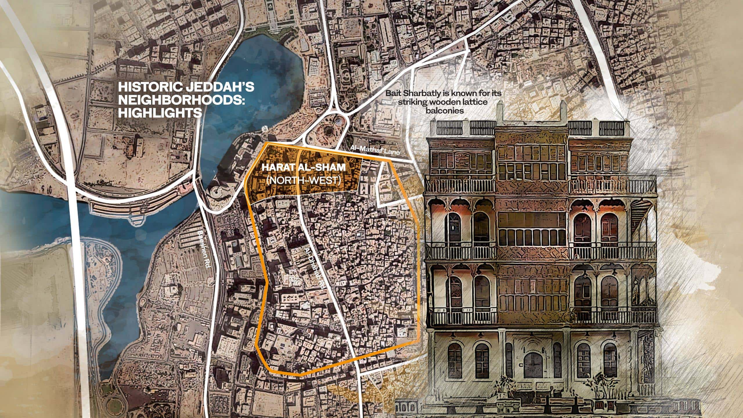


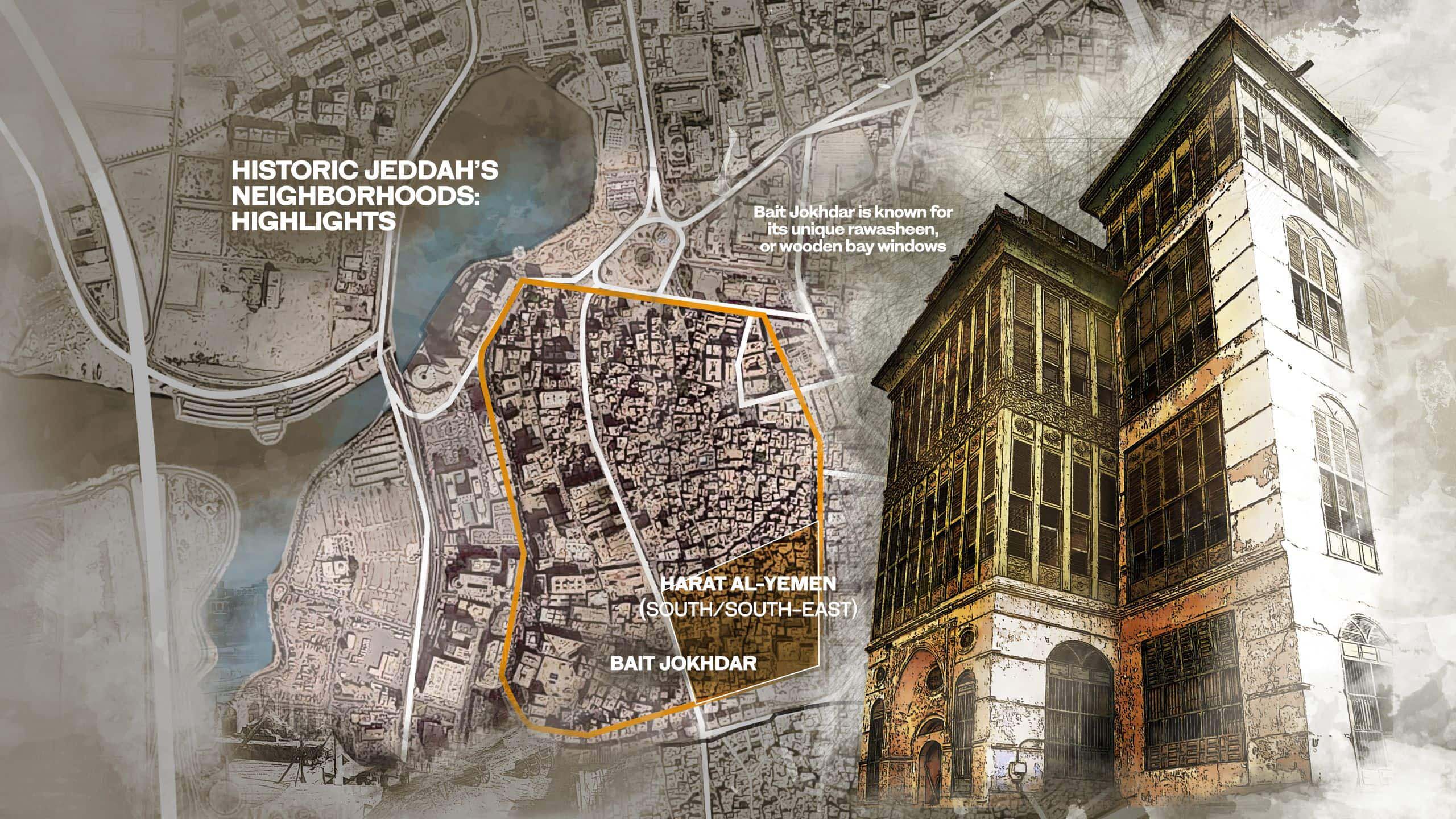

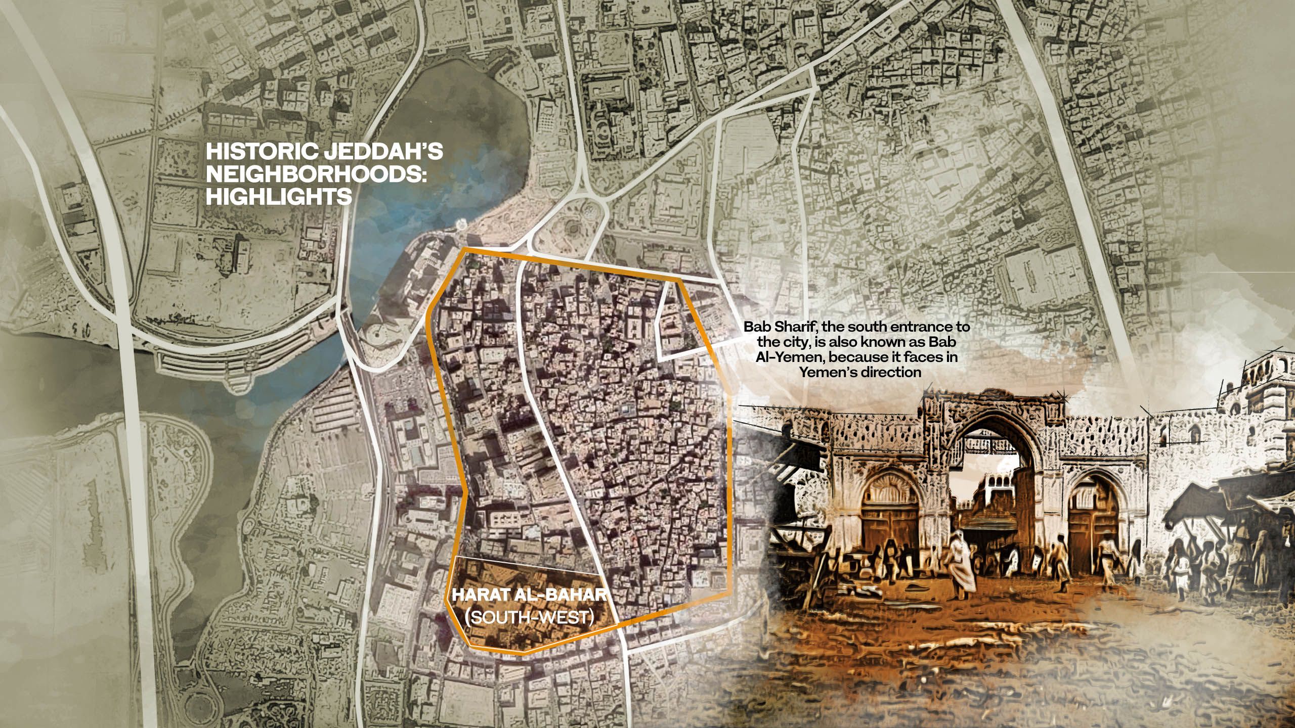
Hima Cultural Area
Travelers and armies passed this way


If the rock art found in the Hail region in the northwest of Saudi Arabia testifies to the distant lives and times of the ancestors of today’s Arabs, the petroglyphs and inscriptions found at Hima Wells, 1,000 km to the southeast near the Yemeni border, bear witness to cultural traditions that continue to this day.
In 2021, Hima Cultural Area, situated in an arid, mountainous area in southwest Saudi Arabia, on one of ancient Arabia’s most important caravan routes, became the sixth property in the Kingdom to be inscribed on UNESCO’s World Heritage List.
Professor Robert Bednarik, a prehistorian and expert in rock art who worked on the UNESCO nomination documents for both Hail and Hima, said that the main difference between the complexes at the two sites “is that the former are dominated by Neolithic rock art with its supreme craftsmanship, especially at Shuwaymis, whereas the Hima rock art is mostly more recent.”

Recent is, of course, a relative term when it comes to archaeology. In the words of the UNESCO nomination, the substantial collection of rock art images at Hima, distributed over six core sites, and which depict hunting scenes, fauna, flora and lifestyles, represents “a cultural continuity of 7,000 years.”
But Hima also differs from Hail, said Bednarik, in that it “also features far more rock inscriptions, executed in several scripts, at about 550 sites.
“Some of these report historical events, providing also rock art with historical depth, but also we discovered that rock art had even been created in the past 30 years at Hima.
“So whereas the Neolithic rock art at Hail overwhelms with its remoteness and grandeur, the Hima rock art presents historical continuity with the present, and apparently still plays a role in contemporary Bedouin lives.
“In many cases, it ‘speaks to us’ through inscriptions.”
Many of the Hima petroglyphs, Bednarik said, are nothing less than “manifestations of artistic genius. They were presumably all made with hand-held stone hammers, yet they can express qualities such as serenity, elegance, grace. Petroglyph replication experiments suggest that modern artists would find it difficult to match the quality of the work.”
Artistic elegance aside, Hima is also a precious depository of history, carved in sandstone. In the words of the UNESCO nomination, this is an “undeniably exceptional catalogue of historically anchored productions invested with the beliefs, concerns, desires and priorities of its creators,” representing “the surviving cultural precipitate of 300 to 400 generations.”
The historical importance of the site, centered on the oldest known toll station on an important ancient desert caravan route, lay in its wells, which date back some 3,000 years and are still sources of fresh water.
Trading caravans from Yemen traveling the frankincense road between Najran in the south and the northern parts of Arabia during antiquity were obliged to follow a narrow corridor between the mountains to the west and the fringes of the inhospitable Rub Al-Khali, or Empty Quarter, desert to the east.


For caravans heading north through the desert toward Najd and beyond, the wells at Hima offered the last plentiful supplies of water, and the first for many days for those who had crossed the deserts on the way south.
As the nomination document puts it, “this intensive traffic” through Hima Wells “is reflected in tens of thousands of rock inscriptions written in several scripts, and in at least one hundred thousand petroglyphs, preserved in pristine conditions.”
Bir Hima, said Bednarik, “may be the most important desert well in the world, and it was obviously its presence that gave rise to both the rock art and the inscriptions.
In addition to trade traffic, “great armies camped at Hima, including before the siege of Najran, and individual soldiers left rock inscriptions with names and dates, confirming history.”
Remarkably, at Jabal Dhibah there are three images of what appear to be elephants with mahouts. They would, said Bednarik, “be hard to explain if we didn’t have historical information: Aksumite King Abraha Al-Ashram led an army to Makkah in about 570 CE, and we have inscriptions of it.
“To destroy the Kaaba, he had with him at least one elephant, and probably several, as he laid stone tracks across the desert so they could walk on the soft sand.
“This is what I mean by this site bringing history to life.”
This event is the reason that in Islamic tradition the year 570, in which the Prophet Muhammad was born, is known as the Year of the Elephant. As the 105th chapter of the Qur’an — “Al-Fil,” or “The Elephant” — records, Al-Ashram’s army was defeated thanks to divine intervention.
One translation reads:
“Have you not seen how your Lord dealt with the Owners of the Elephant?
Did He not make their plot go astray?
And sent against them birds, in flocks,
Striking them with stones of Sijjil (shale)
And made them like an empty field of stalks.”
To gaze upon the rock-carved elephants at Hima and to recall the lines from the Qur’an is to experience an extraordinary confluence of religious tradition and history.
The six individual properties that comprise the UNESCO site at Hima are rich with information about the past, said Sandra Olsen, professor of museum studies and senior curator of archaeology in the Biodiversity Institute at the University of Kansas, and a member of the Arabian Rock Art Heritage Project.


Professor Sandra Olsen: she estimates that most of the rock art at Hima dates to between the 7th century BCE to about 500 CE.
Professor Sandra Olsen: she estimates that most of the rock art at Hima dates to between the 7th century BCE to about 500 CE.
“First, the sheer quantity of rock art panels is remarkable,” Olsen said.
“They are varied in subjects and inform us regarding the many cultures that lived in the region or passed through along the Incense Route.
“The ancient Bedouin, as well as those who occupy the area today, depended heavily on the wells here, making it a crucial pathway for trade and ideal for nomadic pastoralism.”
Understanding the rock art along this trade route “depends on understanding something of the history of Al-Ukhdud, named for the Himyaritic king Dhu Nuwas, which was destroyed in 520 or 523.
“It lies at the southwestern end of this segment of the Incense Route, while Qaryat Al-Faw (ancient capital of the first Kindah kingdom, 700 km southwest of modern-day Riyadh) was to the northeast.”
Occupied from about the 4th century BCE, Qaryat Al-Faw “was apparently attacked by numerous outside armies, as recorded in Sabaean accounts,” and the rock carvings along the route between the two ancient cities offer a pictorial record of a period of history that might otherwise have drifted, unsubstantiated, into myth.
The Hima rock art also sheds light on some of the domestic breeds raised by the pastoralists of the region.
“For example, their cattle were not the long-horn type pictured in the north, but looked more like the Egyptian cattle, with lyre-shaped horns,” Olsen said.
“Fat-tailed sheep are also shown here, but not in the northern petroglyphs.”
Fat-tailed sheep, first recorded at Uruk in Mesopotamia in 3,000 BCE, were valued for the fat in their tails and bodies, which was used in cooking and played an important part in nutrition. The breed may have been brought south along the trade routes from Mesopotamia.
On one panel, incised images of cattle were painted, “probably with henna, which would have been traded in from Egypt, perhaps in exchange for aromatics like frankincense and myrrh.”
In addition to such pastoral scenes, the rock faces at Hima echo with the sounds of long-forgotten battles, with warriors mounted on horses and camels.
“The horses in the Hima battle scenes are very stylized, so one cannot say with certainty that they were Arabian,” said Olsen, an expert in the evolution of the relationship between horses and human beings in ancient history.
“There are many battle scenes and warriors depicted, but they lack inscriptions naming the specific battle, who the warring cultures were and when the battles took place.”


Depictions of goddesses mingle with images of wild animals, including camels and leopards, and warriors on horseback.
Depictions of goddesses mingle with images of wild animals, including camels and leopards, and warriors on horseback.
Aside from the tell-tale unique depiction of Al-Ashram’s elephants, isolating individual events is especially challenging, because here “there was considerable conflict, especially when Al-Ukhdud was occupied, and so many different groups — Arabs, Christians, Jews, and even some Persians, so it is difficult to accurately and with certainty identify the players in these scenes.”
Nevertheless, the panels offer “considerable information on human armor and weaponry, horse armor, camel saddles, and other important information about the warriors.”
The most significant battle scene is at a site called A’abar Harema, “a huge and complex scene with cavalry, cameleers and infantrymen.”
The execution of the rock art at Hima differs from that of Saudi Arabia’s northern petroglyph sites.
“The technique for producing the Hima rock art consists of very shallow scraping through the desert varnish to reveal the lighter, unoxidized natural rock below,” Olsen said.
“This is a late technique, unlike the deeply incised images at Shuwaymis and Jubbah and other Neolithic outcrops in the north.”
Consequently, Olsen said, “I would estimate that the bulk of the rock art at Hima dates to perhaps the 7th century BCE to the mid-first millennium.”
Hima’s secrets have been given up slowly, over many decades. Exploration of the region began in the mid-20th century, when the British soldier Harry St. John Bridger Philby, who became an adviser to Ibn Saud, mapped the area of the modern-day Saudi-Yemeni border and explored deep into the Empty Quarter.
Philby, traveling by camel, recorded many examples of rock art, but it was only when he returned as part of the Philby-Ryckmans-Lippens expedition in 1951-52 that the true scale of the Hima rock art complex began to emerge. Philby and his team, traveling from Jeddah to Riyadh, photographed more than 200 petroglyphs, found mainly in the Hima area.
Hima is also a depository of words, as well as pictures.
In 2007, the joint Saudi-French Archaeological and Epigraphic Mission to Najran, or MAFSN, began a series of surveys in the Hima area. Its objective was to make an exhaustive inventory of the thousands of individual scripts in the region, and more than 16,000 texts have been entered into the MAFSN database.
An initial analysis published in 2022 in the journal Proceedings of the Seminar for Arabian Studies, revealed the extent to which Hima was a melting pot of ancient peoples.
“It is evident from the written documents found in the region that three groups of people frequented Hima in historical times and up until late antiquity,” wrote historian Alessia Prioletta, a member of the French National Center for Scientific Research, in her paper, “The inscriptions in Ancient South Arabian script from Hima: a preliminary historical and cultural appraisal.”
These were the “dwellers of Najran and Qaryat Al-Faw, who went to Hima for commercial reasons, people from the southern Arabian kingdoms, who stopped there with their caravans or their armies, and finally the nomadic pastoralists.”


The province of Najran is famed for its spectacular historic mud-brick architecture.
The province of Najran is famed for its spectacular historic mud-brick architecture.
In leaving their names etched into the rocks, many of these people left a remarkable record of their passing. Two pieces of graffiti in particular, left by Sabaeans from the south, offer an enticing glimpse of this lost world.
One, writes Prioletta, was “carved by the servant of a Sabaean mukarrib named Sumhuali,” and the other “mentions ‘the caravan — mrkbt — of the king of Saba’.” A text inscribed alongside the latter “confirms the commercial nature of these journeys, as well as the fact that different members of the same tribe could often join these enterprises.”
As much as is already understood about Hima, this is a site that still retains as many secrets as it has divulged, and will remain a tantalising destination for generations of archaeologists, historians and tourists.
“Hima has been explored for many decades, but much more needs to be done,” said Olsen.
“Site surveys and excavations could reveal much more about the various cultures that occupied this region or passed through it en route to other destinations.
“In term of its global significance, I would say that it represents an important time in the history of Arabia, one with many unresolved mysteries” — mysteries which, thanks to the protection afforded the site by UNESCO World Heritage status, will now be preserved until they are eventually solved.
“That it is to be preserved for prosperity is critical,” said Olsen, “so that future archaeologists, historians and epigraphers will have the opportunity to study it in detail.”

Hundreds of prehistoric petroglyphs and inscriptions were left by ancient traders travelling between Najran and northern Arabia.
CAPTION XXXXX


Generations passed through Hima, leaving their mark on the sandstone rocks, and on history.
Generations passed through Hima, leaving their mark on the sandstone rocks, and on history.

“Manifestations of artistic genius ... all made with hand-held stone hammers, yet they express qualities such as serenity, elegance, grace.”
“Manifestations of artistic genius ... all made with hand-held stone hammers, yet they express qualities such as serenity, elegance, grace.”

For caravans heading north through the desert toward Najd and beyond, the wells at Hima offered the last plentiful supplies of water.
For caravans heading north through the desert toward Najd and beyond, the wells at Hima offered the last plentiful supplies of water.

Carvings of three elephants, with riders, testify to an invasion in 570 CE by the forces of the African-Yemeni Kingdom of Askum, which the Quran records was defeated by divine intervention.
Carvings of three elephants, with riders, testify to an invasion in 570 CE by the forces of the African-Yemeni Kingdom of Askum, which the Quran records was defeated by divine intervention.


One of several petroglyphs believed to represent an ancient goddess of fertility.
One of several petroglyphs believed to represent an ancient goddess of fertility.


Diriyah: At-Turaif
Birthplace of the Kingdom of Saudi Arabia
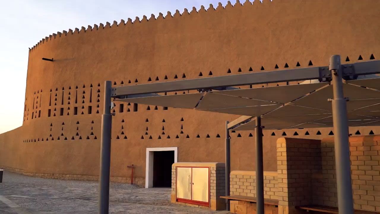

Nestling in a bend of the Wadi Hanifa, just 10 kilometers northwest of the mighty Kingdom Center tower at the heart of the bustling modern metropolis of Riyadh, can be found the remains of an earlier capital.
This is At-Turaif, a breathtaking collection of mudbrick palaces, houses and mosques, encircled by a mighty wall, which in the 18th century became the beating heart of the First Saudi State, established in the oasis of Diriyah in 1744.
Together, in the words of the UNESCO nomination that saw At-Turaif inscribed on the World Heritage List in 2010, these constitute “the pre-eminent example of Najdi architectural style, a significant constructive tradition that developed in central Arabia … and contribute to the world’s cultural diversity.”
Diriyah itself, offering fertile land and plentiful water supplies, had been settled in 1446 by forebears of the House of Saud. When they migrated to the Wadi Hanifa from their original settlement at the original Diriyah, near modern-day Qatif on the Gulf coast, they brought the name of their old home with them.
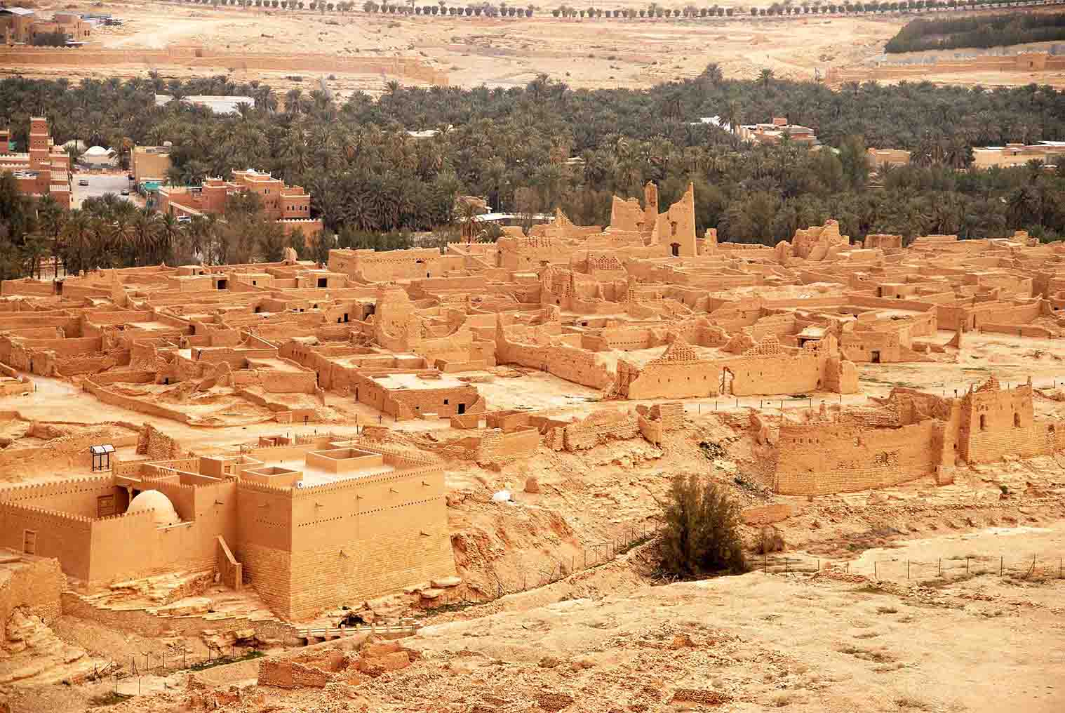
Today, some of the buildings at At-Turaif, bearing the scars of a proud but ultimately doomed stand against the might of the Ottoman war machine in 1818, are in ruins.
Others, including Salwa Palace, the home and seat of government of the third Imam of Diriyah, Saud Al-Kabir (or Saud the Great), on which work began in 1750, are sufficiently intact to remain imposing.
The entire site, however, recognized by UNESCO as being of “outstanding universal value,” is precious to the Saudi people, not only as the birthplace of the Kingdom of Saudi Arabia, but also as a symbol of the rise and triumph of the house of Al-Saud over seemingly impossible odds.
At-Turaif did not simply fall into disrepair, a victim of neglect or changing fashions. This is a ghost city, battered and blasted by Ottoman cannon during a heroic siege of Diriyah in 1818 that ended in a wholesale massacre.
During the lengthy siege, captured defenders were beheaded and their heads, or sometimes just their ears, were sent back to Cairo for bounty.
When Diriyah finally fell after a valiant six-month defense, many Saudis were exiled, tortured or executed on the orders of Ibrahim Pasha, the Egyptian general who had led his forces in a two-year campaign against the Saudis at the bidding of the Ottomans.
Imam Abdullah, the last ruler of the First Saudi State, who surrendered At-Turaif to the invaders only when the suffering of his people had become too much for him to bear, was taken in chains to Constantinople, where he was executed.
Before they withdrew from Najd, the Egyptians laid waste to Diriyah, destroying buildings and fortifications and cutting down every date palm. In 1819, the town was visited by a British army officer, who reported that “it is now in ruins, and the inhabitants who were spared, or escaped from the slaughter, have principally sought shelter in Riyadh.”
Badran Al-Honaihen takes us on an exclusive walk around At-Turaif and shows us what makes its architecture unique and sustainable.
Within months of the Egyptians’ withdrawal, Saudi survivors began to rebuild the city, but in 1821 it was destroyed for a second time by another Ottoman expedition to the area.
Undeterred, the Saudis rose again, this time under the leadership of Imam Turki bin Abdullah Al-Saud. In 1823, he drove out the Ottomans and, with Diriyah and At-Turaif in ruins, chose the nearby intact garrison town of Riyadh as the capital of the Second Saudi State.
Saudi Arabia’s path to statehood was still strewn with barriers. In 1834, Imam Turki was assassinated and years of civil war ended only when his son, Faisal bin Turki bin Abdullah, returned from captivity in Egypt and restored Saudi authority. Following his death in 1865, however, the state was once again riven by in-fighting, until in 1891 it was overthrown by the rival Rashidi dynasty.
Among the Saudis who sought refuge in Kuwait was a young boy, aged about 16. Abdul Aziz bin Abdul Rahman bin Faisal Al-Saud, the son of the exiled ruler of Riyadh, was destined to become better known to the world as Ibn Saud.
The story of how he led a small band of warriors to recapture Riyadh in 1902, restoring the House of Saud, was told by Gertrude Bell, the British political officer in Iraq, in a report written for London in 1917.
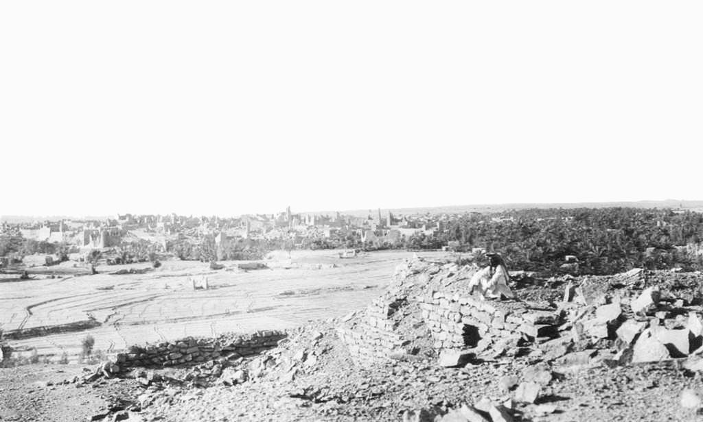
“With a force of some eighty camel riders,” she wrote, “Abdul Aziz swooped down upon Riyadh, surprised Rashid’s garrison, slew his representative and proclaimed his own accession from the recaptured city.”
So was the modern state of Saudi Arabia conceived, but it would not be an easy gestation.
Ibn Saud and the growing band of Bedouin tribes that began flocking to his banner repelled a series of attacks on his territory, first by Ottoman forces and then by the Hashemites of the Hejaz.
Gradually, though, Ibn Saud expanded the territory under his control, until in 1924 his forces seized Makkah, driving out the Hashemite Sharif Hussain. Ibn Saud united the kingdoms of Najd and Hejaz as one, and on Sept. 23, 1932, proclaimed the foundation of the modern Kingdom of Saudi Arabia.
As the capital of the new Saudi state, Riyadh thrived. During the 1970s, Diriyah would rise again, as a new city on the outskirts of the metropolis, but after 1818 the royal quarter of At-Turaif, abandoned behind the remains of its shattered walls, was never occupied again.
For UNESCO, At-Turaif is blessed with many attributes that justify its recognition of “outstanding universal value,” among them the remains of a large number of palaces, built at different times by successive rulers.
Several buildings and the city wall have been restored, to give some idea of how the entire site might have looked during its imposing heyday.
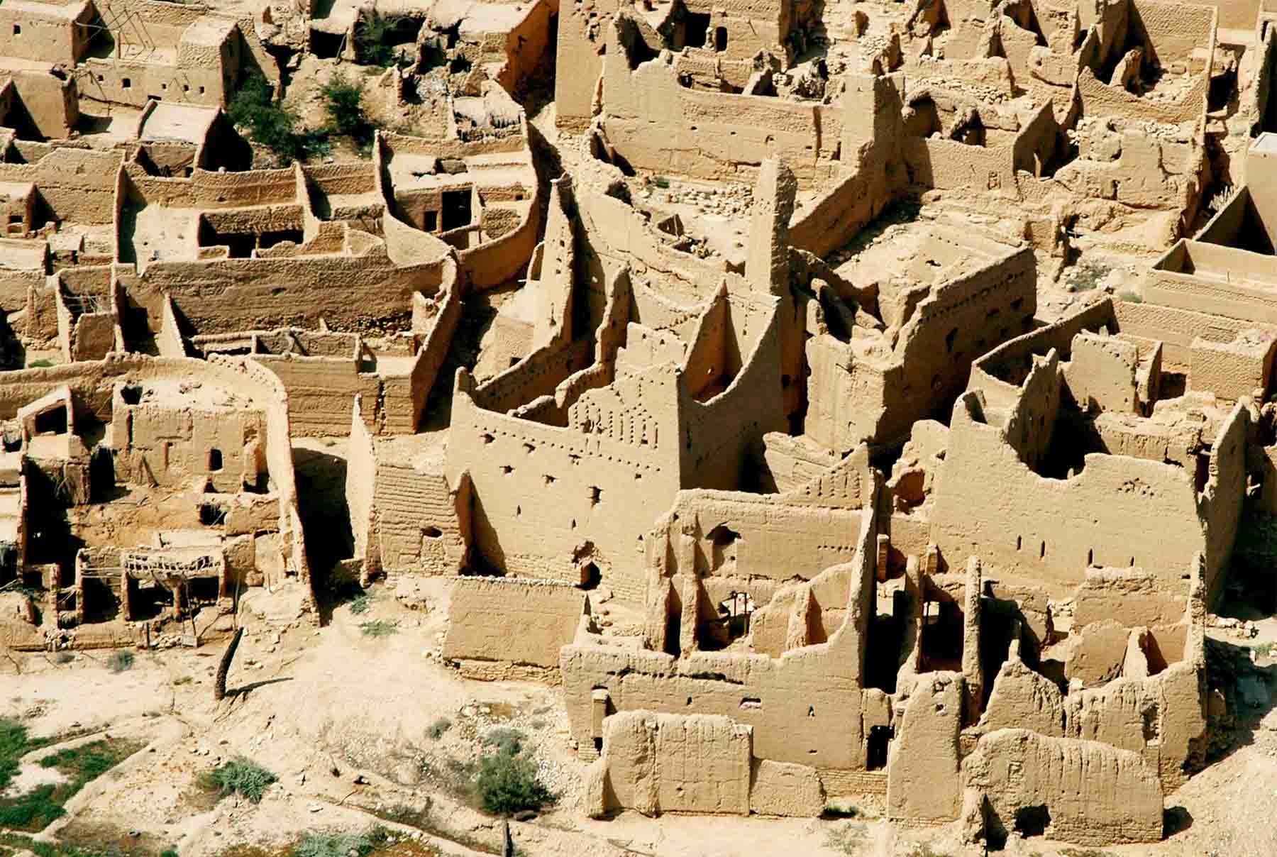
The site as a whole, unified by the striking colors and textures of the clay and limestone building materials obtained from the bed of Wadi Hanifa, reinforced with timber from the tamarisk tree, “is an urban and architectural monument presenting the culture and lifestyle of the First Saudi State, direct ancestor of the modern Kingdom of Saudi Arabia.”
“The number of palaces that have been discovered until now in At-Turaif district is 13,” said Badran Al-Honaihen, the site’s culture and heritage manager.
“Most of the palaces belonged to members of the royal family during the First Saudi State. Three imams lived in Salwa Palace, which is the most important palace in the center of the district, over 10,000-square-meters and overlooking a beautiful view of Wadi Hanifa.”
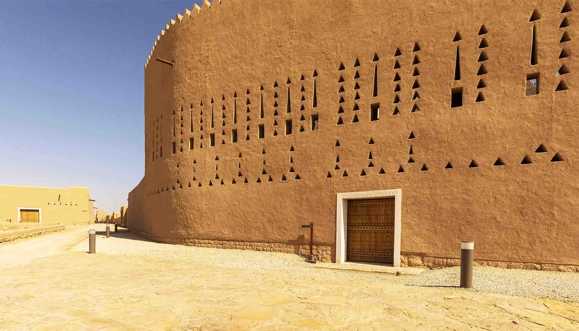
Salwa Palace, a complex of seven buildings on which work began in about 1750, is the largest palace in the entire Najd region. Alongside it can be seen the remains of the Bait Al-Mal, the state treasury, built between 1803 and 1814 during the reign of Saud Al-Kabir.
At-Turaif, added Al-Honaihen, is also home to Imam Mohammed bin Saud’s mosque. “The imams of the First Saudi State used to pray there, and it was the scene of many political incidents during that period.” It was also one of the most important mosques in the region, and at one point “the number of worshipers who used to go there exceeded 3,000, which shows how large the First Saudi State was during its glory days.”
In its time, the mosque was also “one of the most important schools of knowledge and education, with lessons in jurisprudence, Shariah and calligraphy.”
Maintaining such buildings, made from mudbricks and susceptible to erosion by rain, is an ongoing task.
“The mudbrick buildings of At-Turaif have been there for more than 250 years and have survived erosion, brutal invasion by the Ottoman Empire and many other problems,” said Al-Honaihen.
This, he added, is a lesson in sustainability reliant on materials taken from the local environment, and one that has been learnt afresh by modern craftsmen who were trained “to work with mudbricks and focusing on sustainability, whether by using the stones and soil from the wadi or by using the local plants and trees that were used to create such tall buildings as Salwa Palace.”
The ruins, said architect Simone Ricca, a heritage conservation expert who helped to prepare Saudi Arabia’s successful UNESCO application for At-Turaif, “have been preserved with attention paid to the traditional building techniques.”
Equally important is the damage wrought by the siege of 1818, another tacit reminder of the Kingdom’s heritage. “The site is, of course, important historically as the birthplace of Saudi Arabia,” he added, “but it is also a quite extraordinary mudbrick village,” reflecting a unique architectural style and know-how.
“The height of the facades of the palaces are very impressive, among the highest mudbrick structures we have. As such they convey the capacity of these materials to create architecture that represented power.
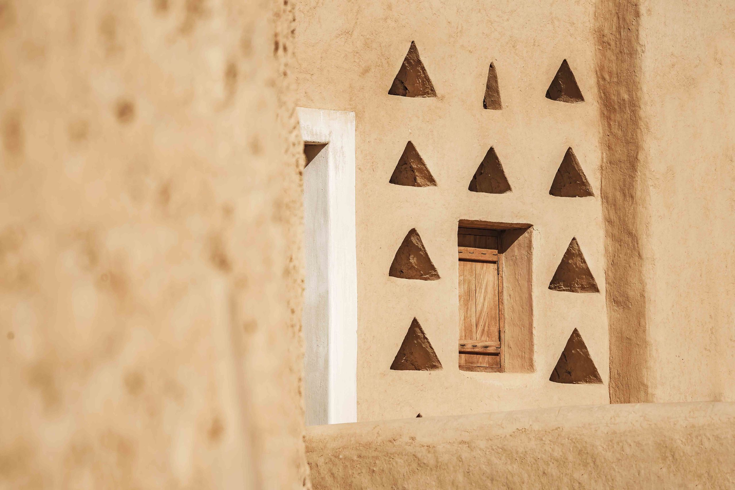
“It is very impressive, and the skill shown in At-Turaif is quite unique at the national level.”
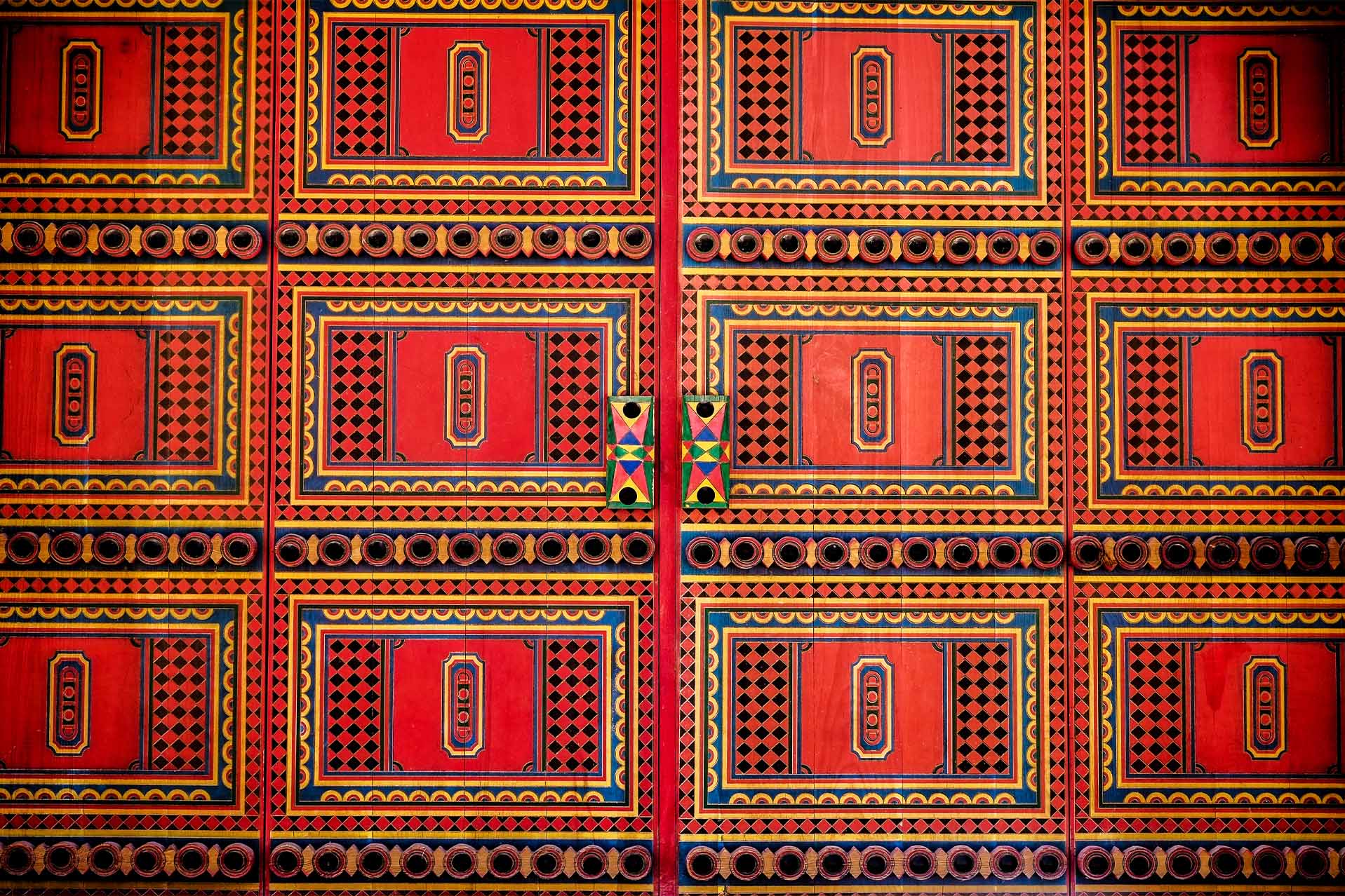
For Ricca, At-Turaif and the Diriyah cultural development that has sprung up around it are the ultimate expressions of Saudi Arabia’s determination that its historic sites should thrive by playing a viable part in the modern world.
“From the beginning, Saudi Arabia has had this vision that these sites should be adapted to cater to visitors’ needs, and that they represent an opportunity for development,” he said.
“With this approach, the sites are preserved according to UNESCO guidelines and they are demonstrated to be assets that can generate income as well as memories.”
In the late 1970s, the British author and historian Robert Lacey, who lived in Saudi Arabia for two and a half years, visited the ruins of At-Turaif, which he found “almost as the Turks left them a century and a half ago.”
“The palm trees grew again after Ibrahim Pasha had departed, but their leaves shade a ghost town,” he wrote in his 1981 book “The Kingdom.”
“There is the palace where the Al-Saud entertained in their glory 400 or 500 Bedouin every day. Nearby is the stud where, it is said, 300 of Arabia’s finest horses were stabled. There are mosques, shops, watchtowers, homes, the busy structure of an entire metropolis, all open to the sky and eerily vacated like a sand-blown Pompeii.”
The Saudis, he added, “left the shell of their old capital behind them, an enduring reminder of the frontiers of the possible.”
Today, as the centerpiece of the ambitious Diriyah mega-project, At-Turaif is once again at the frontiers of the possible.
“This is not a theme park,” said Jerry Inzerillo, who, as group CEO of the Diriyah Company, was charged with creating at Diriyah “the world’s largest cultural and heritage development.”
At-Turaif, he said, “is a sacred site and in order to protect it we are positioning it as a jewel in a necklace.”
That necklace is the large and vibrant community and major tourism destination that has grown around At-Turaif, transforming Diriyah into a living cultural center, complete with universities, homes, multiple hotels, restaurants, museums, galleries and other cultural attractions, in which ultimately tens of thousands of people will live, work and relax.
When complete, Diriyah is expected to attract 25 million visitors every year, from Saudi Arabia and overseas.
Inzerillo, who as president of Kerzner International gave the world such attractions as the Atlantis in Dubai and the One & Only chain of resorts, anticipates no problem in establishing Diriyah, with At-Turaif at its heart, as one of the world’s must-visit destinations.
“I’ve spent a lot of my career making famous places where there was no authenticity, nothing much to work with,” he said. “I had to use fantasy, create make-believe places such as Atlantis to capture people’s imagination.
“I would suggest to you that that’s a much more difficult exercise than it is when you’re dealing with authenticity and the richness of the many historical and cultural sites that Saudi Arabia has, such as at Diriyah. So, my job now is really just one of creating exposure, of spreading the word.”
As they become more widely known around the world, he believes, the Kingdom’s UNESCO sites “will become to Saudi Arabia as the Acropolis is to Greece and the Coliseum is to Rome.
“We’re not naive,” he added. “We know there are a lot of pre-existing stereotypical attitudes or ideas about what the Kingdom is.
“But it’s our job is to welcome people here, to say come and see for yourself the beautiful Nabataean tombs of AlUla, visit Historic Jeddah, the ancient rock art of Hail, the palm groves of Al-Ahsa and Diriyah — and you will be astounded.”

The mudbrick district of At-Turaif bears the scars of Diriyah’s heroic but ultimately doomed six-month resistance against Ottoman forces in 1818. (Historical Diriyah Development Program)
The mudbrick district of At-Turaif bears the scars of Diriyah’s heroic but ultimately doomed six-month resistance against Ottoman forces in 1818. (Historical Diriyah Development Program)

A photograph of the ruins of At-Turaif taken in 1917 by the British agent Harry St John Bridger Philby, who settled in Jeddah and became an advisor to Ibn Saud. (Diriyah Company)
A photograph of the ruins of At-Turaif taken in 1917 by the British agent Harry St John Bridger Philby, who settled in Jeddah and became an advisor to Ibn Saud. (Diriyah Company)

The protected historic quarter of At-Turaif is at the heart of a project to transform Diriyah into a global cultural destination celebrating the birthplace of Saudi Arabia. (Historical Diriyah Development Program)
The protected historic quarter of At-Turaif is at the heart of a project to transform Diriyah into a global cultural destination celebrating the birthplace of Saudi Arabia. (Historical Diriyah Development Program)

Architectural details unique to Saudi Arabia’s Najd region can be seen on the carefully conserved walls of Prince Saad bin Saud Palace. (Diriyah Company)
Architectural details unique to Saudi Arabia’s Najd region can be seen on the carefully conserved walls of Prince Saad bin Saud Palace. (Diriyah Company)

Unique architectural details found throughout At-Turaif include triangular ventilation openings, part of an ingenious early air-conditioning system designed to create airflow and lower temperatures inside the buildings. (Diriyah Company)
Unique architectural details found throughout At-Turaif include triangular ventilation openings, part of an ingenious early air-conditioning system designed to create airflow and lower temperatures inside the buildings. (Diriyah Company)

A typical Najdi design on a door in Diriyah’s Bujairi district, opposite the royal quarter of At-Turaif. (Shutterstock)
A typical Najdi design on a door in Diriyah’s Bujairi district, opposite the royal quarter of At-Turaif. (Shutterstock)

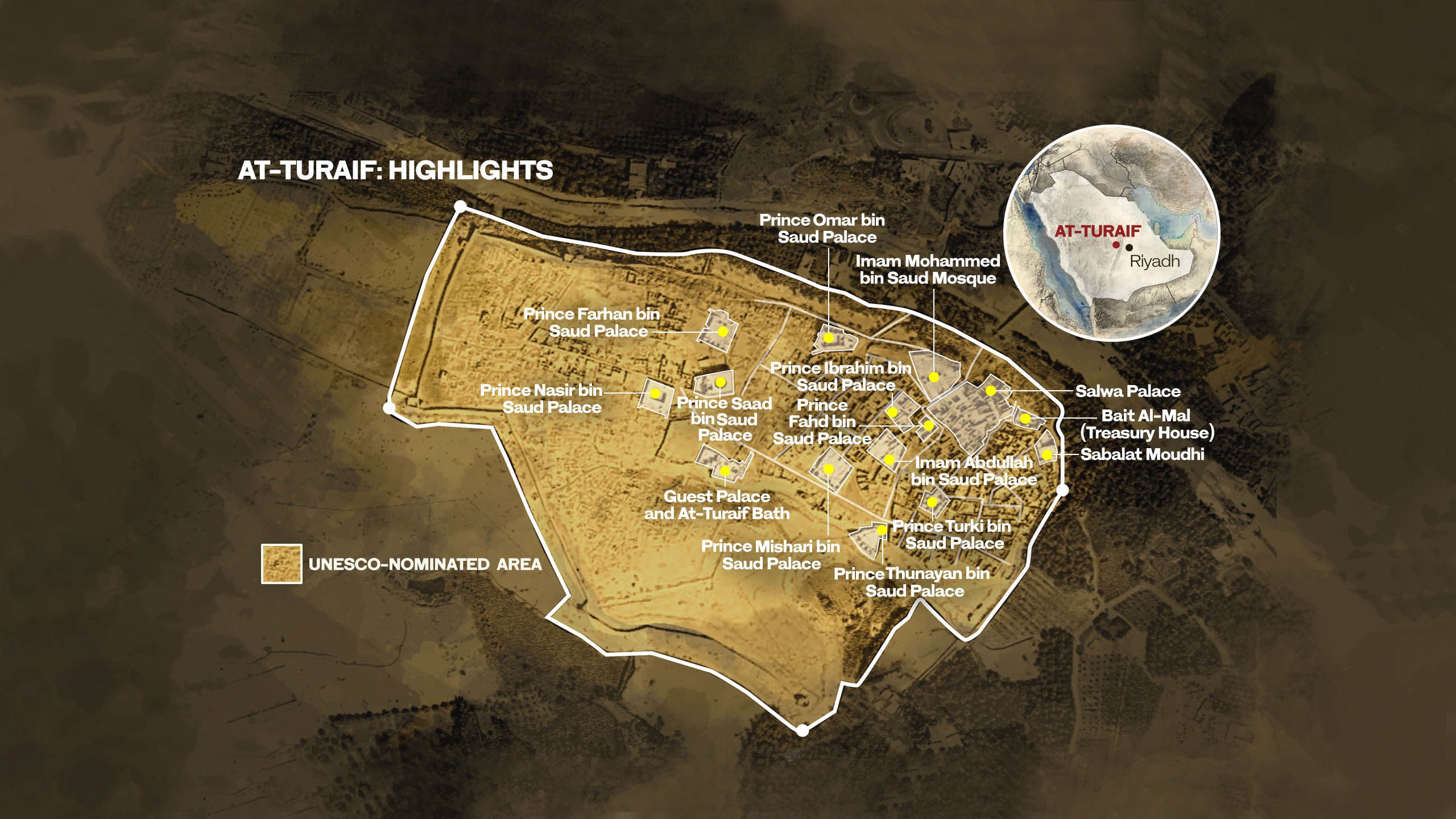

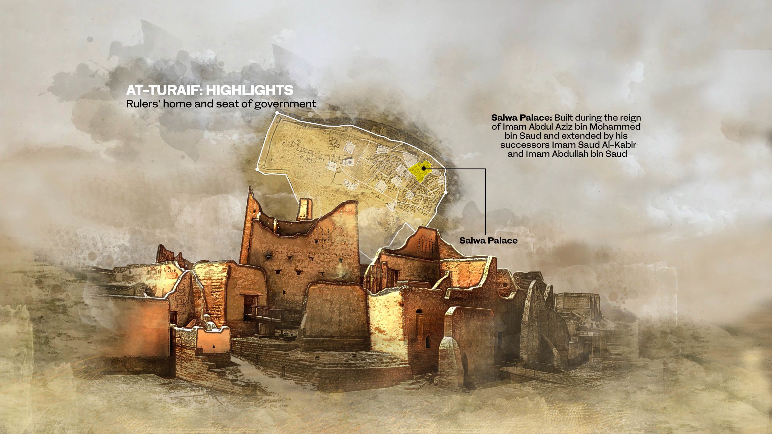

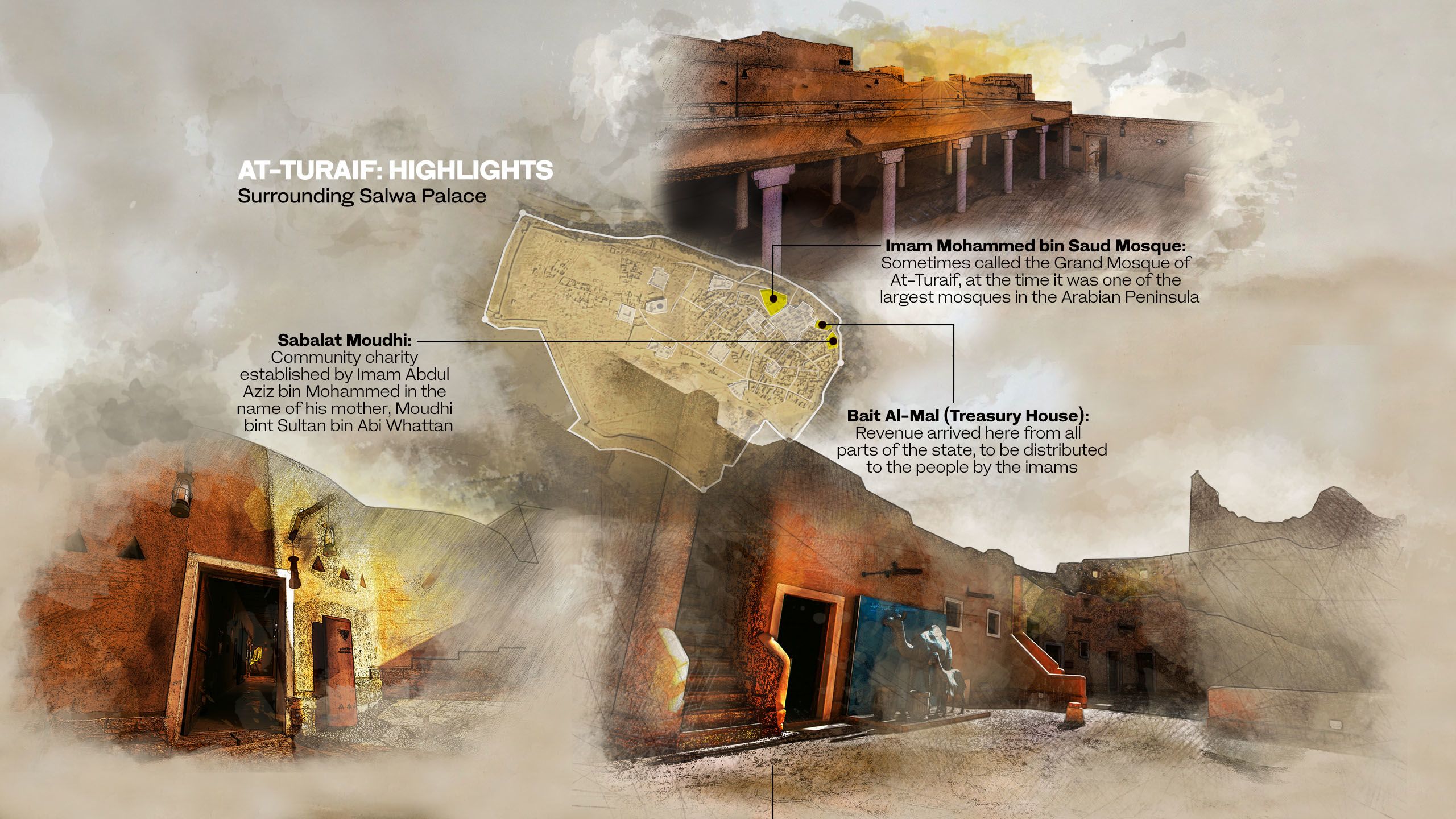


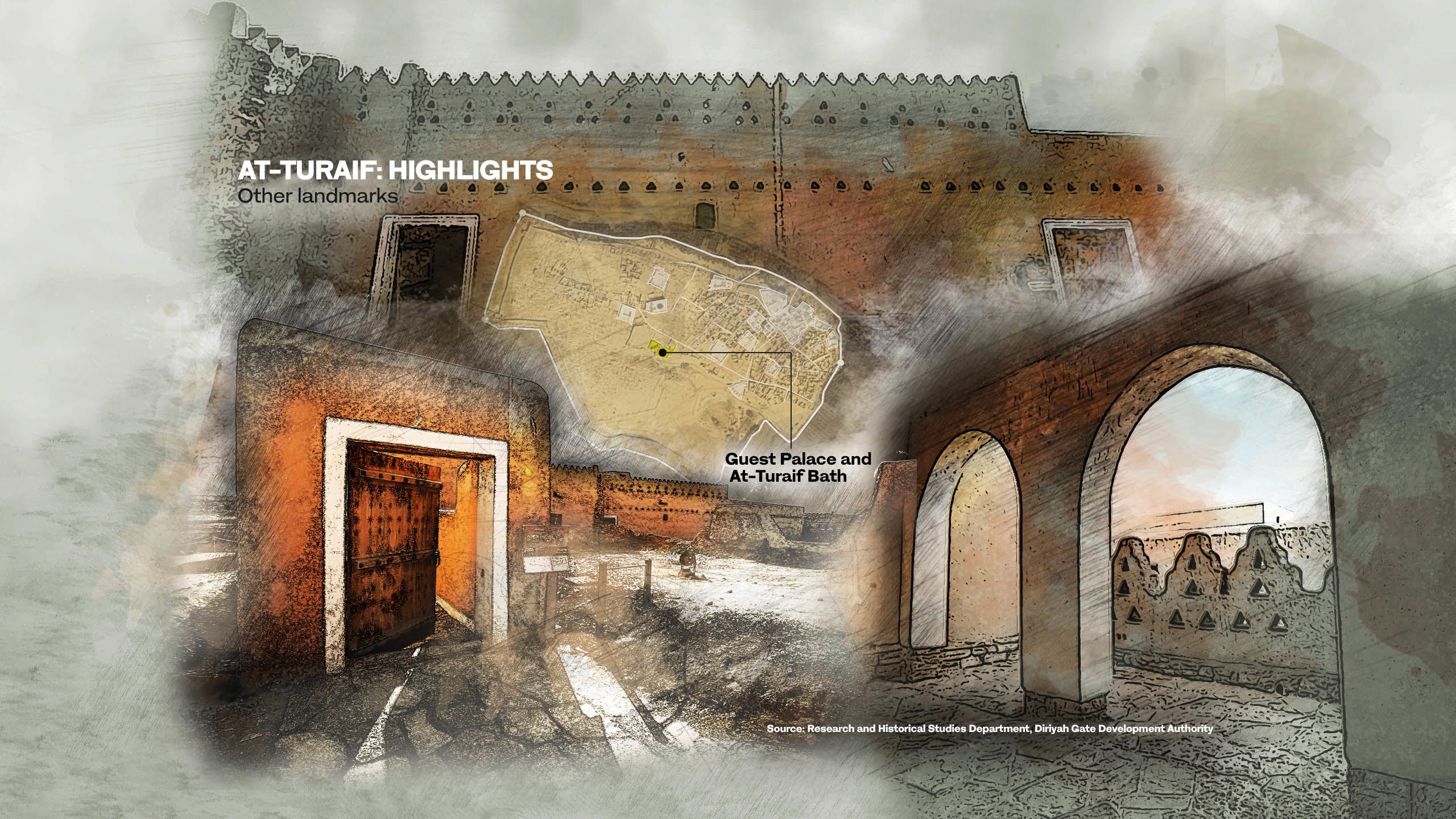
Credits
Writer: Jonathan Gornall
Research: Rawan Radwan, Lojien Ben Gassem, Gabriele Malvisi
Editor: Mo Gannon, Tarek Ali Ahmad
Creative director: Simon Khalil
Designer: Omar Nashashibi
Graphics: Douglas Okasaki
Video producer: Mohammed Qenan
Video editor: Hasenin Fadhel
Picture researcher: Sheila Mayo
Copy editor: Sarah Mills
Social media: Jad Bitar, Kateryna Kadabashy
Producer: Arkan Aladnani
Editor-in-Chief: Faisal J. Abbas