
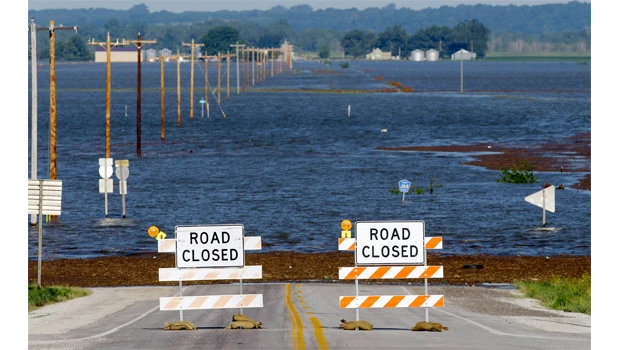
- HAMBURG, Iowa: Water that has been pouring through a breached Missouri River levee finally reached a makeshift barrier that is a small Iowa town’s only hope of avoiding major flooding, authorities said Thursday.
The water, which breached the primary levee south of Hamburg on Monday and has been slowly advancing over the surrounding farmland, reached the 8-foot-tall (2 1/2-meter-tall) levee late Wednesday, Army Corps of Engineers spokesman Carlos Lazo said. There were no immediate problems reported along the structure, where officials expect about 5 feet (1 1/2 meters) of water to eventually collect.
The water appeared to be about 2 feet (a half-meter) deep Thursday morning, according to an Associated Press reporter in Hamburg.
Crews finished work on the 3-mile-long (5-kilometer-long) levee on Wednesday by covering it with plastic to reduce erosion. And most of those living in the threatened parts of town have cleared out.
Any hopes that the breaches might alleviate the long-term flooding threat for communities downstream were short-lived, as river levels that dipped slightly from the release of pressure began rising again Wednesday.
The river has been rising for weeks as the corps releases increasing amounts of water from its upstream dams to clear out heavy spring rain and snowmelt. Releases at Gavins Point Dam in South Dakota hit the maximum planned amount of 150,000 cubic feet (4,250 cubic meters) of water per second Tuesday, and the corps wasn’t planning to reduce the amount it’s releasing from its dams until August at the earliest.
Parts of Montana, North Dakota and South Dakota already have been flooded, and towns and cities farther south were still bracing for the worst. South Dakota officials estimate the state already has spent about $10 million in the first two weeks of work to prevent flooding in Pierre, Fort Pierre and Dakota Dunes.
River towns and cities in Nebraska, Iowa and Missouri continued bolstering their own flood defenses Wednesday, probing for any potential weakness.
“If there are weak spots, they will be shown very soon,” National Weather Service hydrologist Dave Pearson said.
Officials predict the river downstream of the six dams will remain 5 to 7 feet (about 2 meters) above flood stage at most places in Nebraska and Iowa, and swell as much as 10 feet (3 meters) above flood stage in Missouri.
Pearson said Monday’s breaches would provide only a temporary dip in river levels. Once the water spreads out, the pressure will build up and the river will rise again.