


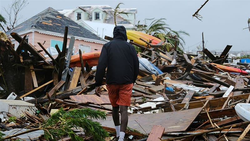
The storm that was Hurricane Dorian was still causing damage in Canada on Sunday, days after causing catastrophic damage and deaths in the Bahamas — where it stalled for 40 hours as a Category 5 hurricane — and then further damage along the US coast. It tied with a 1935 storm for the highest sustained wind speeds when making landfall. Dorian made 2019 the fourth consecutive year to experience a Category 5 hurricane in the Atlantic Ocean — the longest such streak on record.
Dorian follows other recent storms that caused unusual levels of damage, including 2018’s Hurricane Florence, which caused extensive flooding in North Carolina, the unusually deadly and costly Hurricane Maria of 2017 that devastated Puerto Rico, and 2017’s Hurricane Harvey that drenched parts of Texas and became one of the costliest storms ever. Meanwhile, Cyclone Idai devastated parts of East Africa in March, becoming one of the deadliest Indian Ocean cyclones. Also in the spring, Cyclone Fani caused deaths and extensive damage in India and Bangladesh. Earlier this year, in the Pacific, Typhoon Wutip became the first Category 5 tropical cyclone ever observed in the month of February in the Northern Hemisphere.
These streaks of particularly destructive tropical cyclones have raised questions about the effects of anthropogenic climate change on storms. Limitations on data make it difficult to clearly assess the impact and many scientists are reluctant to attribute climate change to any single weather event. Tropical cyclones — called hurricanes in the Atlantic and Caribbean, cyclones in the Indian Ocean, and typhoons in the Pacific Ocean — have occurred throughout human history. One of the reasons recent storms are so damaging is that population growth and development along vulnerable coasts heightens the human and economic cost of storms.
Nonetheless, many climate scientists point to patterns that are already occurring or are expected to occur as Earth’s climate warms in response to greenhouse gas emissions. As climate change increases Earth’s temperature, it increases the potential fuel that drives these large-scale storms, especially as oceans have absorbed more than 90 percent of the increased heat caused by human emissions.
Some of the effects are quite clear. There is extensive scientific research indicating that a warming climate means that tropical cyclones will carry more water, leading to more rainfall. This is a key factor driving extensive flooding, as seen with Hurricane Harvey’s unprecedented rainfall and flooding.
There also are multiple studies and models suggesting that a warming climate will lead to a greater number of severe storms. Research suggests that Atlantic hurricanes, Indian Ocean cyclones and Pacific typhoons will all see increases in storm intensity, though the effect may vary from region to region. For example, depending on which model is used, the frequency of Category 4 and 5 hurricanes along the US coast is projected to increase between 45 and 87 percent, and the number of Category 5 hurricanes has increased in recent years. The potential links between climate change and the overall frequency of tropical cyclones, however, is far less clear, and the total number of such storms could increase or decrease.
It is also clear that sea levels have been rising for some time and are doing so at an increasing rate. This makes storm surges potentially more damaging and increases the extent to which flooding spreads beyond the coastline.
There are studies to suggest that a warmer climate is also leading to more tropical cyclones that “stall” over one place. The evidence for this trend and its link to anthropogenic climate change is less clear, but a studypublished in the journal Nature in 2018 examining the record of tropical cyclones found that their “translation speed has decreased globally by 10 percent over the period 1949 to 2016.” Other researchers have found similar evidence to suggest that storms might stall more often. The potential combination of storms with greater rainfall rates that stall threatens to dump huge amounts of water in specific localities. Hurricane Dorian’s unusually long stall over parts of the Bahamas might be an example of what future storms will look like.
Tropical cyclones that carry more rainfall, are more intense, create greater storm surges, and might stall over specific locations will increase disaster recovery needs. The impacts will not occur evenly around the world. Small states that lack the resources to respond to catastrophic events will need outside help. Even wealthier states, such as the US, will see political impacts if federal-level politicians are reluctant to send resources to hard-hit localities such as Puerto Rico or coastal North Carolina.
As climate change increases Earth’s temperature, it increases the potential fuel that drives these large-scale storms.
Kerry Boyd Anderson
More dangerous storms also will affect transportation, trade and economics. For example, when Typhoon Lekima recently slammed into the Chinese coast, authorities had to temporarily close a high-speed train and cancel thousands of flights. In the long term, intense storms are likely to lead to migration within and outside of countries, as people find they must retreat from vulnerable areas.
There are clear implications for policymaking. More research is needed to provide better data on tropical cyclones and to improve climate change models. Leaders around the world should work together to address the causes of anthropogenic climate change and mitigate its long-term effects. International, national and local leaders need to invest in building resiliency — including transportation networks and communities that can withstand larger storms. Finally, some areas will have to consider retreat away from the coasts.
- Kerry Boyd Anderson is a writer and political risk consultant with more than 14 years’ experience as a professional analyst of international security issues and Middle East political and business risk. Twitter: @KBAresearch


