DUBAI: Satellite imagery obtained by Arab News has revealed the extent of damage to Lebanon’s Beaufort Ridge after the Israeli military said it used hundreds of tons of explosives to destroy an underground Hezbollah tunnel network in the area in late July.
Images taken before and after the operation announced by the IDF on the 31st of July show significant destruction, land clearing and rubble build up in the land and township of Aroun in the surrounds of the UNESCO World Heritage listed Beaufot castle.
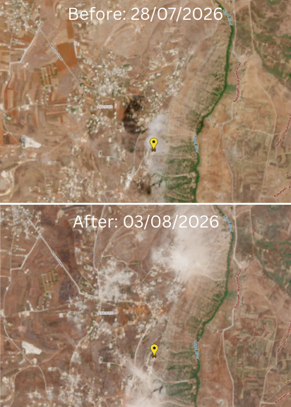
Built around the 12th century AD, the castle has seen its fair share of military campaigns since its beginnings as a crusader fortress. The castle was occupied by the IDF base from 1982 until 2000 during the Israeli occupation of Southern Lebanon with its strategic ridgeline coming under fire once more in the latest conflict.
The attack on the castle’s ridgeline was one of the largest operations to take place since a June agreement called for the Lebanese military to deploy to areas of southern Lebanon where Hezbollah previously maintained a military presence, paving the way for Israeli forces to withdraw from the buffer zone they hold inside Lebanon.
Lebanon's Directorate General of Antiquities said in June that the castle had been under its sole administration since Israel's withdrawal from southern Lebanon in 2000, and said locations depicted in Israeli maps and videos as military infrastructure were away from the archaeological complex.
UNESCO, which had already expressed alarm over strikes near Beaufort earlier in the conflict, said sites under enhanced protection “benefit from the highest level of legal protection against attack and use for military purposes.”
Wholesale destruction in the South
According to Dr. Karim Bitar, lecturer in Middle East studies at Sciences Po Paris and professor at Saint Joseph University of Beirut, the images from Lebanon provide a snapshot of Israel's new strategy in Lebanon.
“What is happening today is significantly different from what happened between 1978 and 2000 when Israel occupied Lebanon," Bitar told Arab News.
"Today, it appears that there is an Israeli willingness not only to occupy part of Lebanon, but to make it uninhabitable, empty of its civilian population.”
The destruction visible around Beaufort forms part of a much wider transformation of southern Lebanon that can be observed from space.
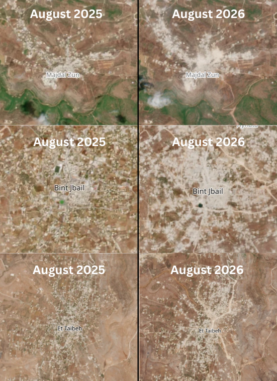
Satellite images of Majdal Zoun taken a year apart show a dramatic expansion of cleared and destroyed areas across the town.
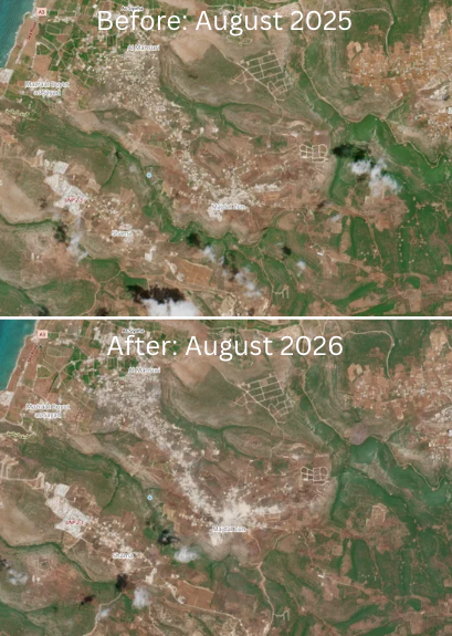
Imagery from August 2025 shows extensive damage but numerous structures still standing. By August 2026, large sections visible in the earlier image had been reduced to cleared ground and rubble.
The town has continued to be a flashpoint despite diplomatic efforts to end the conflict. Two Israeli soldiers were killed in an explosion in Majdal Zoun last week, prompting another wave of Israeli strikes across southern Lebanon.A comparison of satellite imagery from August 2026 and 2025 of the Lebanese town of Majdal Zoun, itself a victim of Israeli
Nearly two years on from an Israeli/Hezbollah ceasefire meant to break the cycle of destruction, the village has gone from partially destroyed to being almost completely wiped out.
In July, a group of UN human rights experts said that the pattern of erasure seen in the south echoed Israel’s tactics in Gaza, where it has been accused of Genocide at the International Court of Justice.
Dr. Bitar warned that international descriptions of the border areas obscure the true humanitarian and political reality on the ground:
“International media are still using expressions like ‘buffer zone,’ or ‘security zone,’ or ‘yellow zone,’ or whatever. And I think these expressions are rather dangerous because they turn a political issue and a philosophical issue," he said
"Because what we are dealing with is dehumanization and the politics of ethnic cleansinginto a purely security framework.”
Israeli forces still control a “security zone” in the south, with Israel arguing that it needs to retain territory until the threat posed by Hezbollah has been removed. Lebanon, by contrast, has pushed for a full Israeli withdrawal as the Lebanese army expands its authority in the border region.
Highlighting the existential nature of the ongoing clearance operations, Dr. Bitar stressed that Israel was attempting to redraw the map of the and permenantly expand their occupation.
“Israel is making daily statements that they intend to remain indefinitely in south Lebanon, just like they intend to remain indefinitely in Gaza and in Syria and let's not forget that the West Bank's annexation is almost complete," he said.
"So what is happening is part of a general Israeli strategy. The expansionism is clear... Today, there is an existential threat facing Lebanon. There is an axis in the region pushing for chaos and fragmentation. Israel wouldn't mind to see Lebanon and Syria dismantled into small sectarian or ethnic statelets.”
“These images should be a wake-up call and a signal to the Lebanese authorities and to Lebanese public opinion and to all those concerned not only about South Lebanon, but also about this country's unity, sovereignty, and territorial integrity." he added.